What would the world look like if every empire were the only land on Earth? In these maps, everything an empire controlled is shown as satellite imagery and everything else has been flooded.
For the 13 country maps we’ve included all the land each country ever controlled, even if it didn’t hold it all at the same time.
Britain’s map shows the original Thirteen Colonies and India, although it never ruled both at once.
That covers colonies, protectorates, mandates and annexations, but also wartime occupations and puppet or client states. Personal unions, where one monarch wore two crowns, count too.
The five ancient empires work differently: each shows a single moment, the empire at its greatest extent. The last two maps show the Axis at its height in 1942 and every country that has ever been communist.
A few ground rules: Antarctic claims are left out, as are informal spheres of influence and raids that lasted less than about a month with no garrison.
Borders were assembled from modern countries and provinces plus historical boundary data, so expect inland borders to be off by tens of kilometres in places, and up to 50-100 km on WWII front lines.
Contents
- British Empire
- French Empire
- Spanish Empire
- Portuguese Empire
- Dutch Empire
- Belgian Empire
- Danish Realm
- German Empire
- Norwegian Realm
- Italian Empire
- Russian Empire
- Swedish Empire
- Empire of Japan
- Mongol Empire
- Byzantine Empire
- Ottoman Empire
- Roman Empire
- Empire of Alexander the Great
- The Axis Powers
- The Communist World
Every Land a Country Ever Controlled
1. British Empire
All land ever under English, Scottish or British rule.
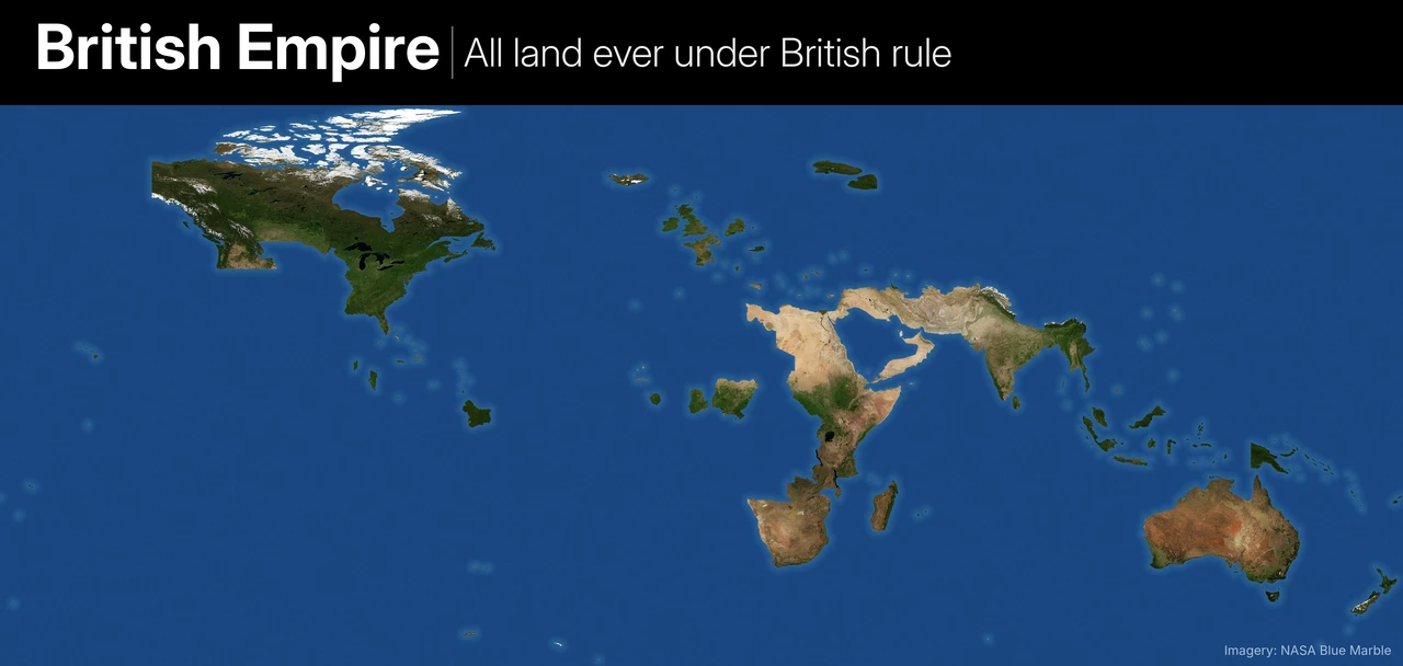
- Included: England, Scotland and the UK plus every colony, protectorate and mandate: the Thirteen Colonies, Florida (1763-83), Canada, the Oregon Country (jointly occupied 1818-46), Rupert’s Land, India, Burma, Ceylon, British Africa, Egypt, Sudan, Palestine, Transjordan, Iraq, the Gulf, Aden, Australia, New Zealand, the Pacific and Caribbean islands, Malaya, Hong Kong and Weihaiwei.
- Medieval France: The Angevin Empire, Aquitaine under the Treaty of Brétigny, Lancastrian France around 1429, and Calais until 1558.
- Occupations: Havana and Manila (1762), Buenos Aires and Montevideo (1806-07), Java (1811-16), Saint-Domingue (1793-98), Napoleonic-era Caribbean islands, Corsica (1794-96), Sicily, Iceland and the Faroes in WWII, Iran outside the Soviet zone, Madagascar (1942), the British zones of Germany and Austria, Trieste, Allied-occupied Constantinople, Murmansk and Arkhangelsk (1918-19), Baku, Batumi and Saigon (1945-46).
- Borderline, included: Hawaii (the Paulet occupation of 1843), Syria and Lebanon (1918-20 and 1941), and Afghanistan, Bhutan and Oman as protectorates or clients.
- Left out: Copenhagen (1807) and Lhasa (1904), held only for weeks; the occupation of Japan, which the US ran; informal influence in Argentina and Siam.
Also watch:
2. French Empire
All land ever under French rule or control.
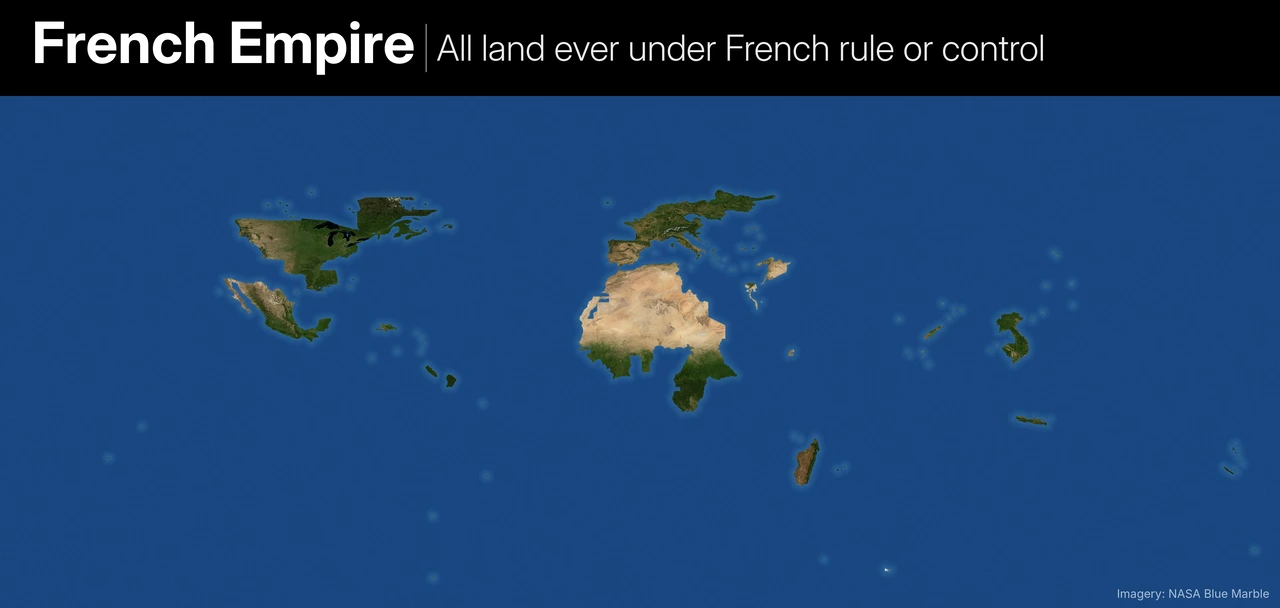
- Included: France and its overseas departments; New France (Quebec, Acadia, the Great Lakes, the Ohio and Illinois country); Louisiana as sold in 1803; the Caribbean including Saint-Domingue; French India including the Northern Circars; Indochina; Kwangchowan; French West and Equatorial Africa; the Maghreb; Madagascar and the Indian Ocean islands; Syria and Lebanon; Cilicia (1919-21); Togo and Cameroon; the Pacific islands; and Mexico under Maximilian (1864-67), a French client.
- Napoleonic Europe: Every annexed département plus every satellite (Holland, Westphalia, Berg, the Confederation of the Rhine, the Kingdom of Italy, Naples, Spain, the Duchy of Warsaw and Switzerland), the occupations of Prussia, Austria and Portugal, the Illyrian Provinces, the 1812 campaign (Lithuania, Belarus and a corridor to Moscow), Egypt and Palestine (1798-1801), Malta and the Ionian Islands.
- Later occupations: The Ruhr and Rhineland, the French zones of Germany and Austria, Allied-occupied Istanbul, Odessa (1918-19) and Beijing (1900-01).
- Left out: Schleswig-Holstein (Denmark was Napoleon’s ally), Sicily, Sardinia and the Balearics (never taken), the wider Deccan and Carnatic (spheres of influence) and the Crusader states.
Also watch this video:
3. Spanish Empire
All land ever under Spanish rule.
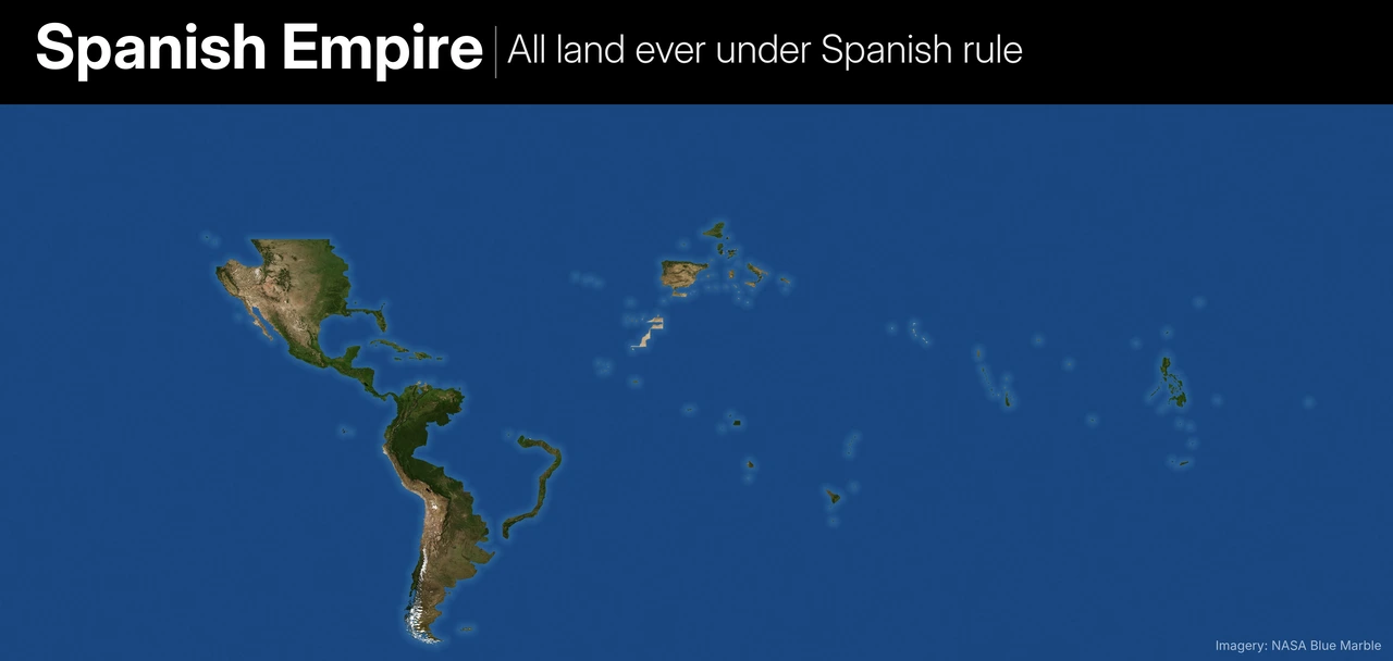
- Included: Spain; Spanish America at its fullest, including the US Southwest, California, Florida and Spanish Louisiana (1762-1803); the Philippines, Guam, the Marianas, Carolines and Palau; Spanish Formosa (1626-42); Spanish Morocco, Ifni, Western Sahara, Equatorial Guinea and the North African presidios; the Spanish Netherlands, Franche-Comté, Milan, Naples, Sicily and Sardinia; and Roussillon until 1659.
- Iberian Union: From 1580 to 1640 Spain’s king also ruled Portugal, so Portugal and the parts of its empire it held in those years are included.
- Borderline, included: Catalan Athens (1379-88), the Valtellina and Savoy (1742-49).
- Left out: Corsica (a papal grant that was never enforced), Belize, the Marshall Islands, England under Philip II and Charles V’s Austrian lands.
4. Portuguese Empire
All land ever under Portuguese rule.
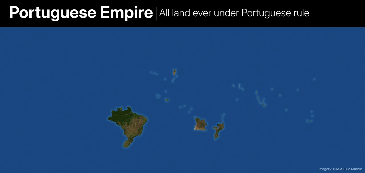
- Included: Portugal, Brazil at its fullest (except Acre), Uruguay (Colonia and Cisplatina, 1817-28), French Guiana (1809-17), Angola, Mozambique, Guinea-Bissau, Cape Verde, São Tomé, Bioko and Annobón (until 1778), the Moroccan forts, the Swahili coast, Hormuz and the Gulf forts, Bahrain (1521-1602), Goa, Daman, Diu and the Bombay coast, coastal Ceylon, Malacca, the Moluccas, Timor and Macau.
- Borderline, included: Nagasaki, which was granted to the Jesuits rather than the Portuguese crown.
- Left out: West Timor, the Chittagong freebooter states (not crown territory) and Kongo beyond Angola.
5. Dutch Empire
All land ever under Dutch rule.
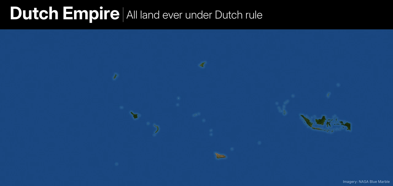
- Included: The Netherlands; Belgium (1815-30); Luxembourg (personal union 1815-90); all of Indonesia including western New Guinea; Suriname, Essequibo, Demerara and Berbice; the Dutch Caribbean, Tobago, St Croix and the British Virgin Islands; New Netherland (the Hudson valley, New Jersey and Delaware); the Dutch Brazil coast (1630-54); the Cape Colony; the Gold Coast, Gorée, Arguin, Luanda and São Tomé (1641-48); Mauritius; coastal Ceylon; posts in Malabar, Coromandel and Bengal; Malacca; Formosa; Dejima; and East Frisia under the Kingdom of Holland.
- Left out: Trading lodges with no territory (Surat, Mocha, Ayutthaya) and Australia, which the Dutch charted but never settled. The Netherlands was itself a French satellite under Napoleon, so those annexations sit on the France map.
6. Belgian Empire
All land ever under Belgian rule or occupation.
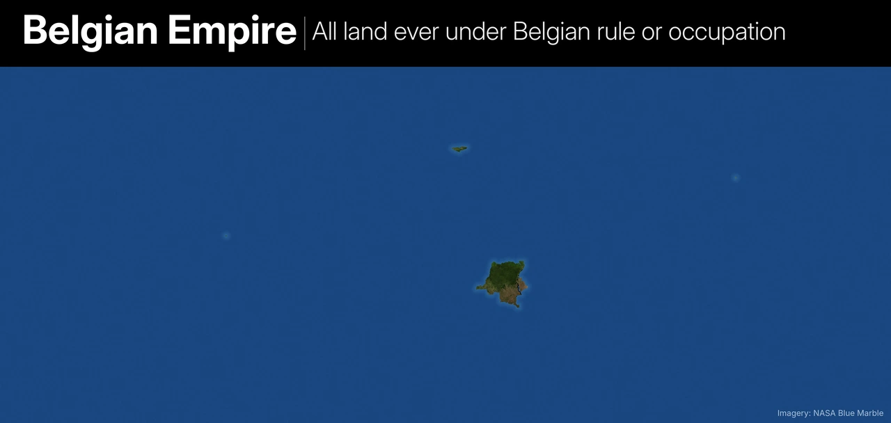
- Included: Belgium, the Congo Free State and Belgian Congo, Ruanda-Urundi, the Lado Enclave, the WWI occupation of western German East Africa (Kigoma-Tabora), the Tianjin concession, the Santo Tomás settlement in Guatemala, and Belgian occupation zones in Germany after both world wars.
- Left out: The Bahr el Ghazal lease, which was never occupied.
7. Danish Realm
All land ever under Danish rule.
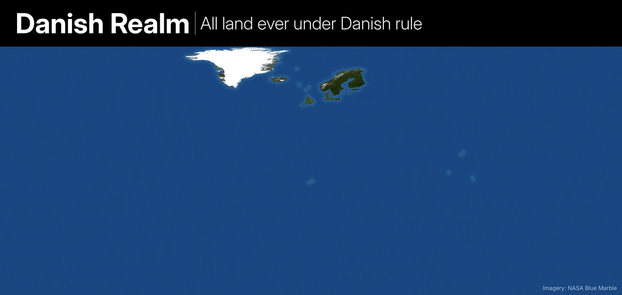
- Kalmar Union: Treated as Danish-led, so all of Sweden and Finland are included.
- Included: Norway, Iceland, Greenland, the Faroes, Orkney and Shetland (until 1468-69); England under Sweyn Forkbeard, Cnut and Harthacnut (1013-42); Schleswig-Holstein; Hamburg, Mecklenburg and Pomerania under Valdemar II; Rügen; Bremen-Verden (1712-15); Oldenburg (1667-1773); Danish Estonia (1219-1346); and the Danish West Indies, Tranquebar, Serampore, the Nicobar Islands and the Gold Coast forts.
- Left out: Svalbard and Bouvet Island, which only became Norwegian after the union ended.
8. German Empire
All land ever under German rule or occupation.
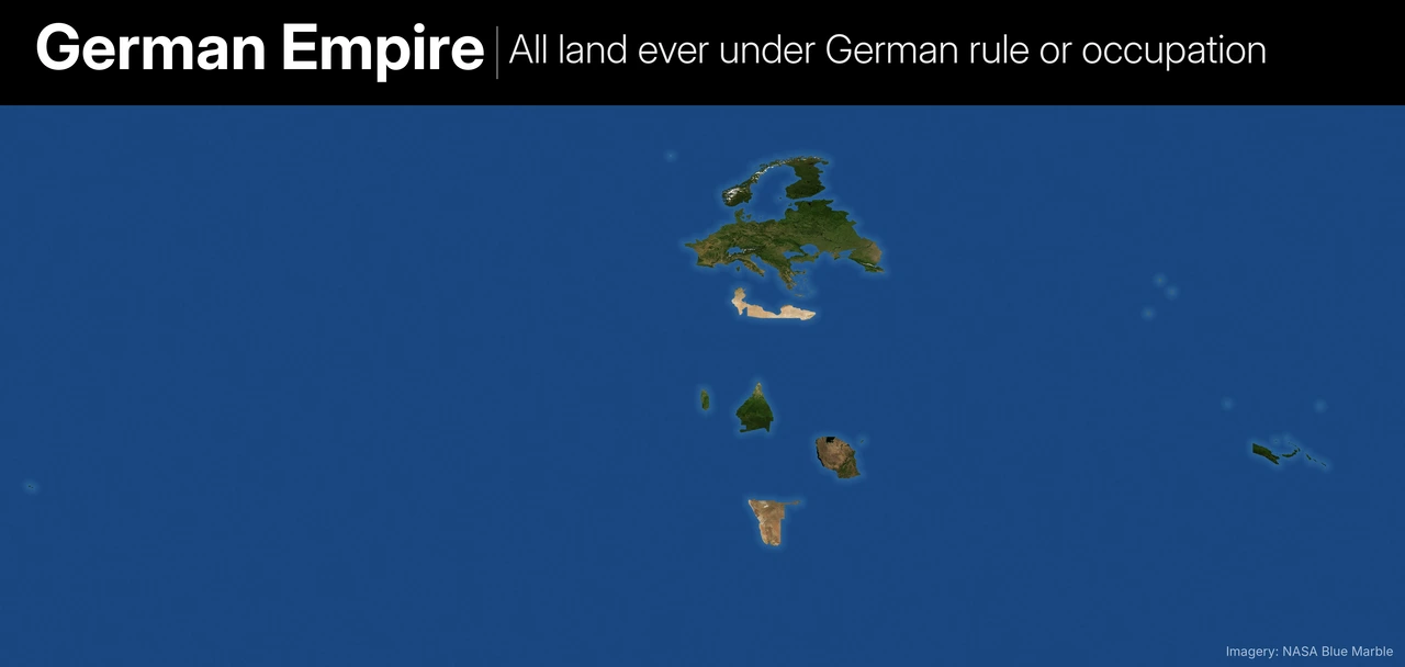
- German Empire, 1871-1918: Including Alsace-Lorraine, Posen, West Prussia, North Schleswig and Memel, plus every colony: Kamerun, German South West Africa, German East Africa, Togo, German New Guinea, Micronesia, Samoa and Kiautschou.
- WWI occupations: Belgium, north-east France, Luxembourg, Poland, the Baltics, Belarus, Ukraine and Crimea (1918), occupied Romania, the client Kingdom of Finland (1918) and Georgia as a German protectorate (1918).
- Nazi Germany at its fullest: The Greater German Reich, the General Government, the Reichskommissariats, the western USSR to the furthest front line, all of metropolitan France, the Low Countries, Denmark, Norway, the Channel Islands, Greece, Yugoslavia, northern Italy (1943-45), Hungary (1944), the puppet states of Slovakia and Croatia, and Tunisia and the Libya-Egypt strip to El Alamein.
- Left out: Vichy France’s colonies, which Germany never administered, and the Holy Roman Empire and other pre-1871 German states.
9. Norwegian Realm
All land ever under the Norwegian crown.
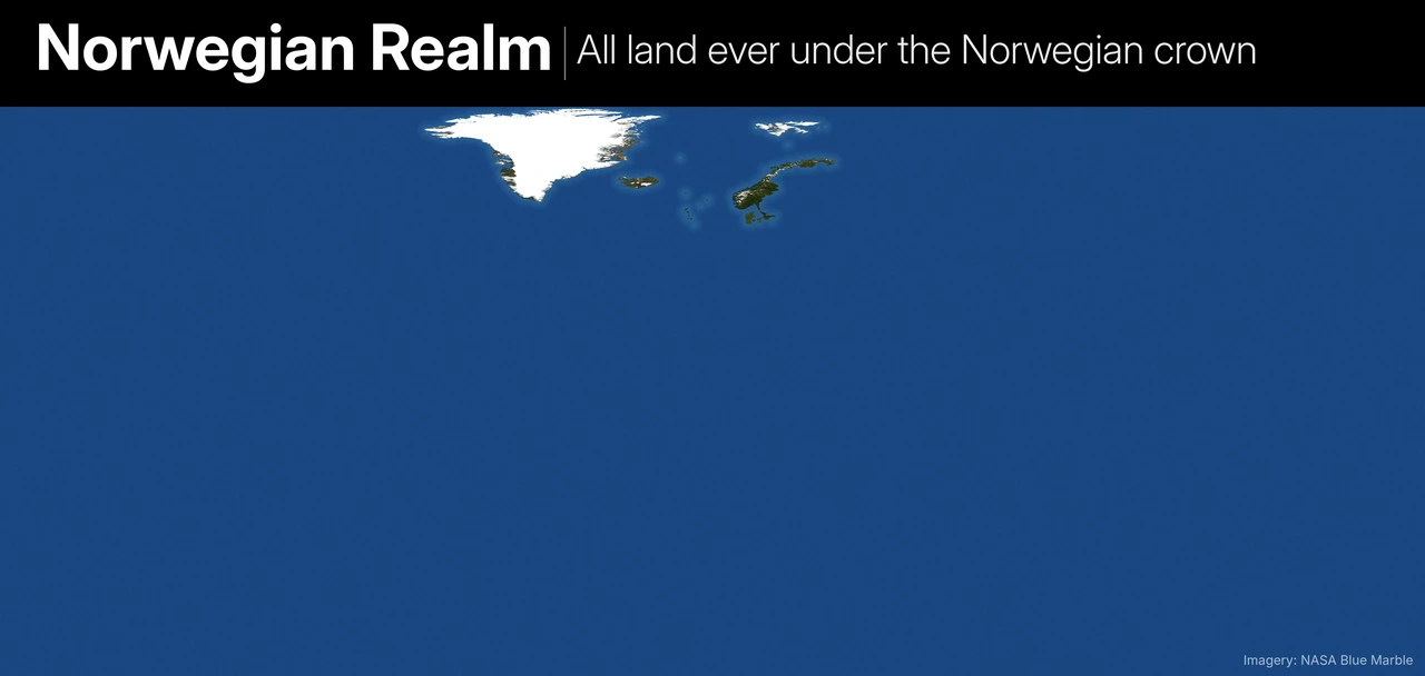
- Included: Norway, Iceland (1262-1814), Greenland, the Faroes, Shetland and Orkney (until 1468-69), the Kingdom of the Isles until 1266 (the Isle of Man, the Hebrides, Arran, Bute and Kintyre), Jämtland, Härjedalen, Bohuslän, Svalbard, Jan Mayen and Bouvet Island.
- Borderline, included: Denmark, Scania and Schleswig, from Magnus the Good’s reign as king of Denmark (1042-47).
- Left out: Sweden (its unions with Norway were under Swedish kings), Viking Dublin and Normandy (Norse, but not the Norwegian crown) and Vinland.
10. Italian Empire
All land ever under Italian (and Savoyard-Sardinian) rule.
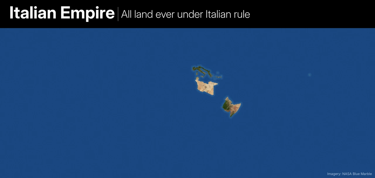
- Included: The Kingdom of Italy and its predecessor Savoy-Sardinia (including Savoy and Nice until 1860); Eritrea, Somaliland, Libya, Ethiopia (1936-41), Albania, the Dodecanese and Tianjin; Fiume, Zara, Istria and the Slovenian coast (1920-47); North Tyrol (1918-20); and the Antalya zone of Turkey (1919-22).
- WWII: South-east France and Corsica (1942-43), Monaco, Ljubljana, Dalmatia, Montenegro, Kosovo and western Macedonia, most of Greece, British Somaliland (1940-41), Sudanese and Kenyan border towns, the Egyptian desert to El Alamein and Tunisia (1942-43).
- Left out: Venice, Genoa and the other states that existed before unification, so Venetian Crete and Cyprus are not shown.
11. Russian Empire
All land ever under Russian or Soviet rule.
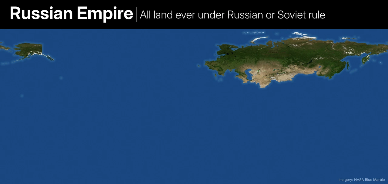
- Included: Muscovy, the Russian Empire at its fullest (Finland, Congress Poland, the Caucasus, Central Asia, Alaska, Fort Ross in California and a fort on Kauai), the USSR at its fullest and the Russian Federation.
- Satellites and occupations: The Warsaw Pact countries, Albania, Mongolia, Manchuria (1900-05 and 1945-46), northern Korea (1945-48), the Soviet zone of Austria, Bornholm, northern Norway (1944-45), Afghanistan (1979-89), northern Iran (several times between 1722 and 1946), Ottoman Armenia (1916-18), the Ionian Islands (1800-07) and the Bay of Kotor (1806-07).
- Borderline, included: Xinjiang, under heavy Soviet control in the 1870s, 1930s and 1940s.
- Left out: Allies that were never satellites, such as Yugoslavia, Cuba and Vietnam.
Also watch this video:
12. Swedish Empire
All land ever under Swedish rule.
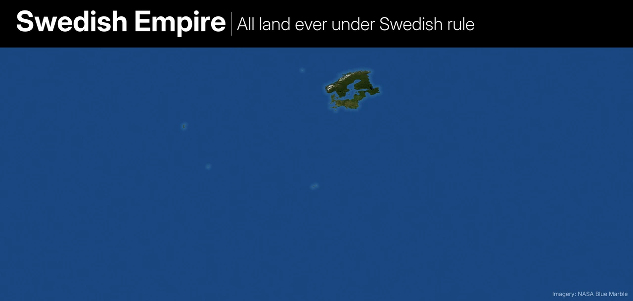
- Included: Sweden, Finland (until 1809), Norway (union 1814-1905), Estonia, Livonia, Ingria, Kexholm, Novgorod (1611-17), Swedish Pomerania, Wismar, Bremen-Verden, New Sweden on the Delaware River, the Gold Coast forts, Saint-Barthélemy (1784-1878) and Guadeloupe (1813-14).
- Wartime occupations: The most debatable part: all of Denmark (1657-60), Poland and Lithuania during the Deluge and under the puppet king Stanisław Leszczyński, and Thirty Years’ War occupations held for a year or more, including Brandenburg, Magdeburg, Saxony, Erfurt, Franconia, Mainz, Augsburg and Olomouc.
- Left out: Bavaria (raids only) and Alsace (handed to France).
13. Empire of Japan
All land ever under Japanese rule or occupation.
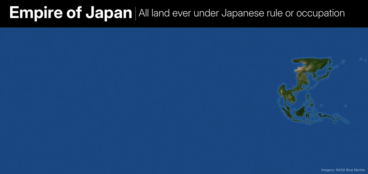
- Included: Japan, Okinawa, Taiwan, Korea, southern Sakhalin and the Kurils (all of Sakhalin 1920-25), the Kwantung lease, Manchukuo, Mengjiang, Shandong (1914-22), the Siberian intervention zone (1918-22), occupied China at its 1944 maximum, Hong Kong, Indochina, Burma, Malaya, Singapore, Borneo, the Philippines, the Dutch East Indies, Timor, the New Guinea coast, the Solomons, the Gilberts, Nauru, Wake, Guam, Attu and Kiska, and the Andaman and Nicobar Islands.
- Borderline, included: Thailand, an ally under Japanese military presence.
- Left out: Macau (neutral) and southern Dutch New Guinea, which was never taken.
The Great Empires at Their Height
14. Mongol Empire
At its greatest extent, around 1279.
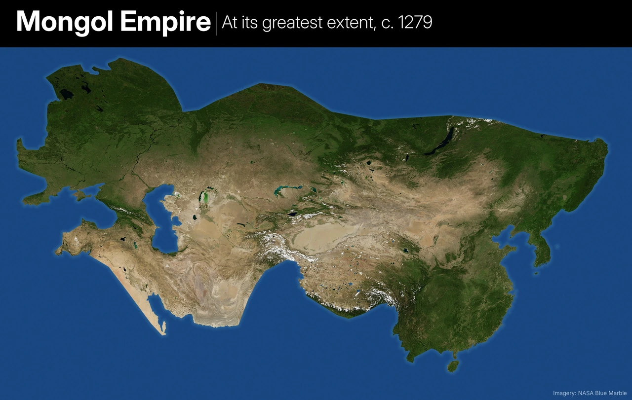
- Included: All four khanates (the Yuan dynasty, the Chagatai Khanate, the Golden Horde and the Ilkhanate) plus Tibet and the vassal Rus’ principalities, the Sultanate of Rum, Georgia and Korea.
- Left out: Trebizond, Bulgaria and Southeast Asian kingdoms that only paid nominal tribute, and Japan and Java, where Mongol invasions failed.
15. Byzantine Empire
At its greatest extent under Justinian I, around 555.
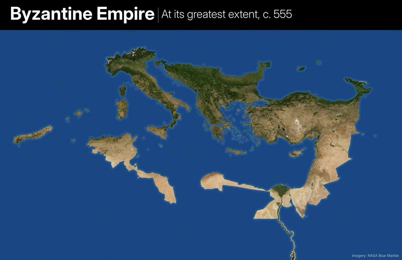
- Included: All of Italy and its islands, Dalmatia, the Balkans south of the Danube, Greece, Anatolia, the Levant, Egypt, coastal Libya, Tunisia, eastern Algeria, Ceuta, the Balearics, southern Spain, western Georgia and the Crimean coast.
- Left out: Pannonia, the Moroccan and Algerian interior and Nubia.
16. Ottoman Empire
At its greatest extent in 1683, on the eve of the Siege of Vienna.
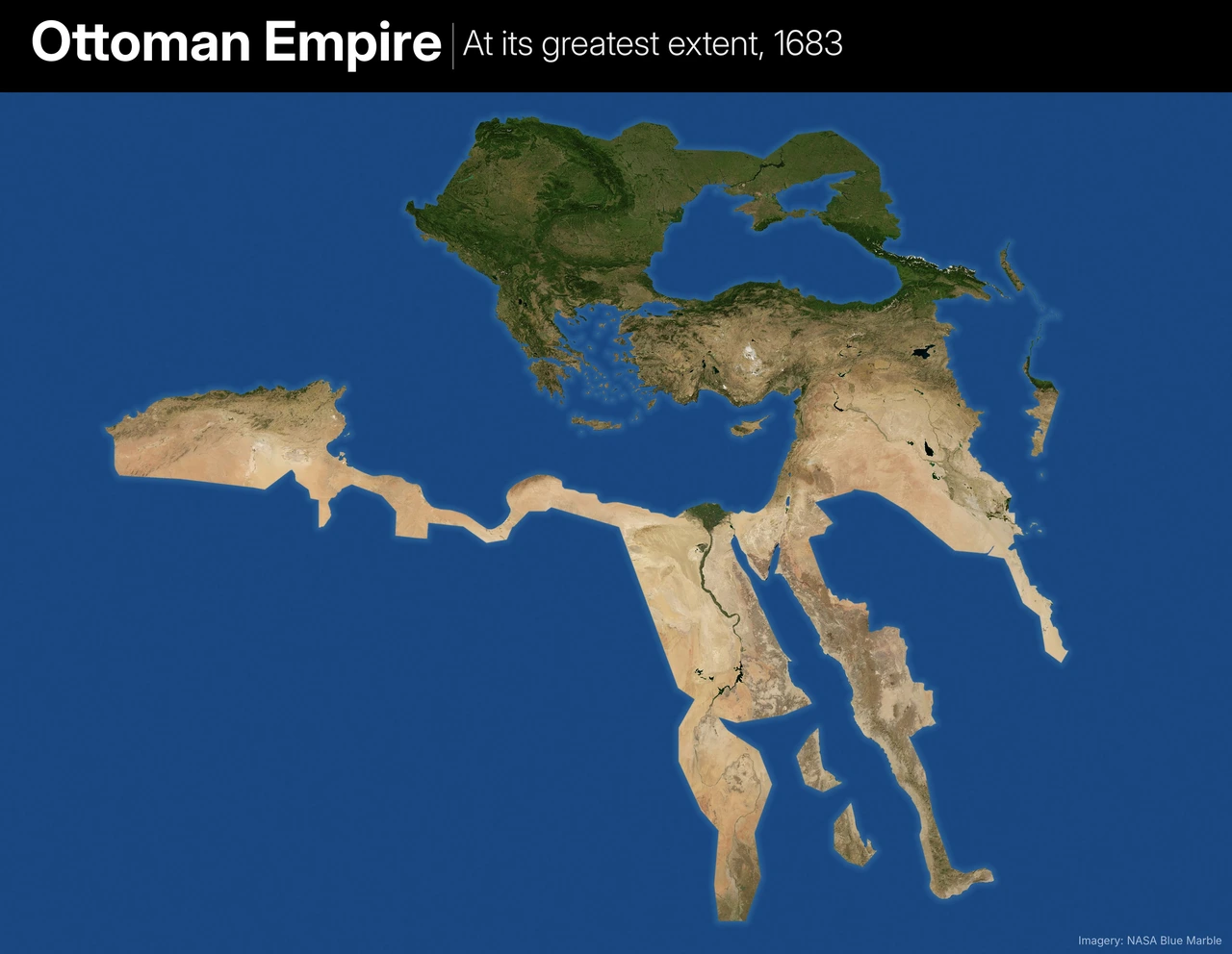
- Included: The core empire plus Ottoman Hungary, Crete, Podolia and Azov, and its vassals: the Crimean Khanate, Wallachia, Moldavia, Transylvania, Upper Hungary, western Georgia, the Sharifate of Mecca and the regencies of Algiers, Tunis and Tripoli.
- Left out: Yemen and al-Hasa, which had already been lost by 1683, Safavid-held Azerbaijan and Kurdistan, and the deep Sahara beyond the North African regencies.
Also watch:
17. Roman Empire
At its greatest extent under Trajan, 117 AD.
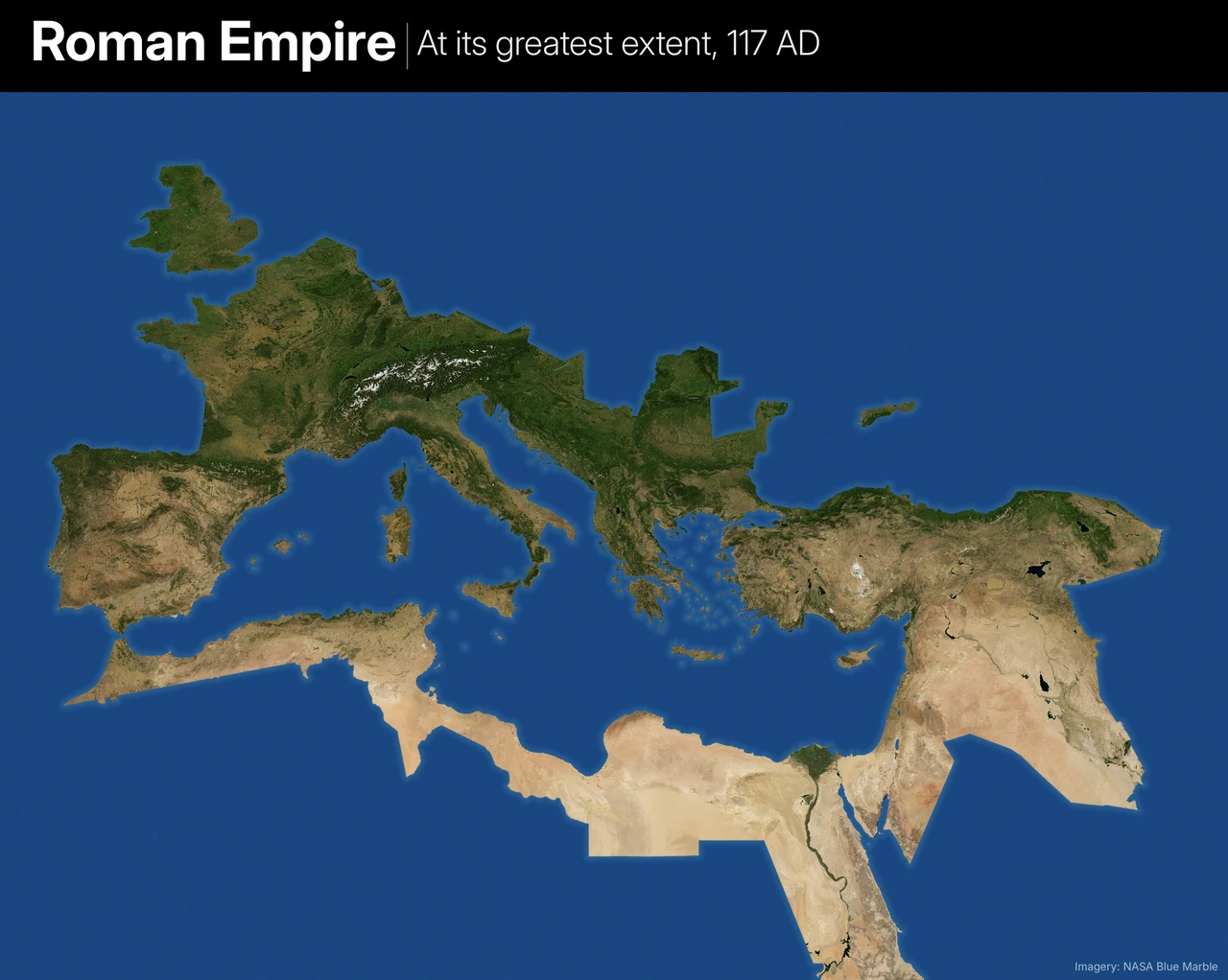
- Included: The empire of 100 AD plus Dacia, Arabia Petraea, Armenia and Mesopotamia (116-17), southwest Germany and England up to the Tyne-Solway line.
- Caveat: Mesopotamia was already in revolt in 117 and was abandoned by Hadrian the next year.
- Left out: Scotland, Ireland, Germany beyond the frontier and client kingdoms in the Caucasus.
18. Empire of Alexander the Great
At its greatest extent, 323 BC.
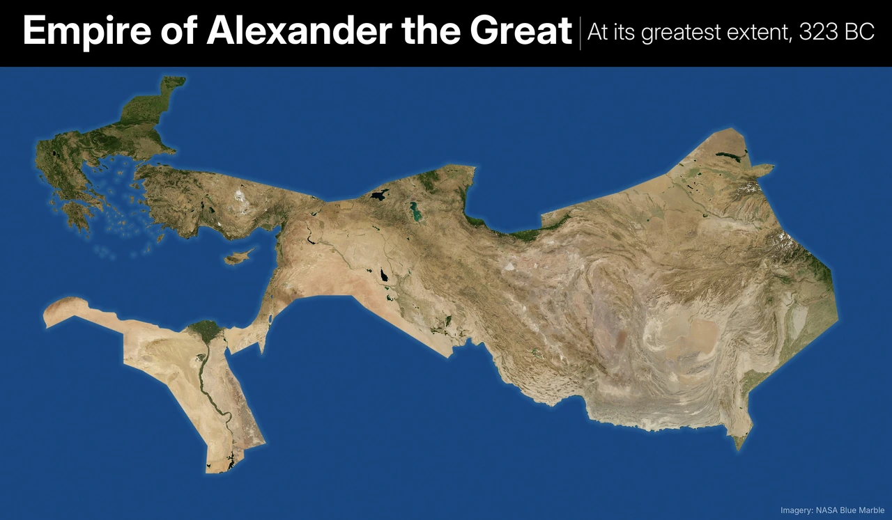
- Included: Macedonia, Greece (under the League of Corinth), Thrace, Asia Minor, the Levant, Egypt, Mesopotamia, Persia, Bactria, Sogdiana, the Indus valley and Punjab, and Cyprus.
- Left out: Crete, Cappadocia, Pontus, Armenia and Arabia, which were never really subdued.
The 20th Century
19. The Axis Powers
The greatest extent of Axis control, 1942.
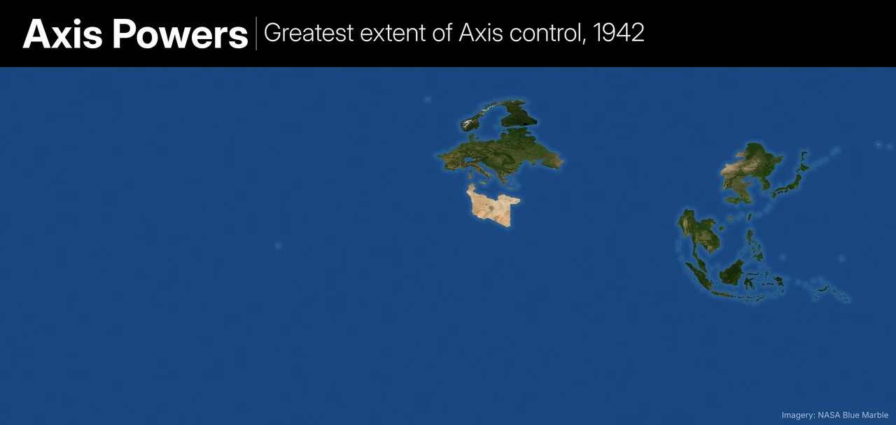
- How it was drawn: Each front is shown at its furthest point in 1942: the Pacific in August-November, El Alamein in July-October, and Stalingrad and the Caucasus in November. It is a composite rather than a single day.
- Included: Germany, Italy and Japan with all their annexations, occupations and puppets; Axis members Hungary, Romania, Bulgaria, Slovakia, Croatia and Thailand; co-belligerent Finland; Manchukuo and occupied China; and the Pacific out to Guadalcanal and the Aleutians.
- Left out: Vichy France’s colonies that the Axis never occupied (only Tunisia and Indochina are shown), Iraq in 1941 and Italian East Africa, both lost before 1942.
Also see this video:
And this post: What If Nazi Germany Won World War II? Fictional & Historical Scenarios
20. The Communist World
Every country that was or is communist.
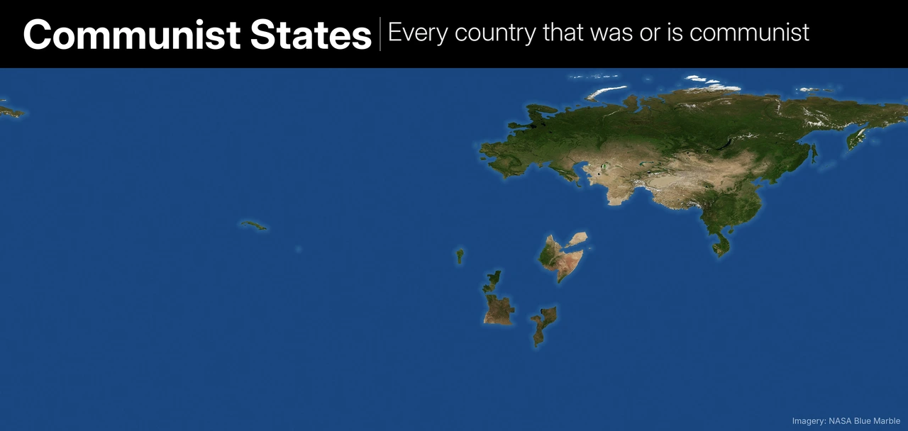
- Included: Every self-declared Marxist-Leninist state, shown with today’s borders: the USSR, Mongolia, the Eastern Bloc, Yugoslavia, Albania, China, North Korea, Vietnam, Laos, Cambodia, Cuba, Afghanistan, South Yemen, Ethiopia, Somalia, Angola, Mozambique, Benin, Congo-Brazzaville and Grenada. Short-lived ones such as the Bavarian Soviet Republic and Red Finland (1918) are shown too.
- Left out: Socialist-leaning countries that weren’t one-party Marxist-Leninist states, such as Nicaragua under the Sandinistas, Chile under Allende, Zimbabwe and Tanzania, as well as Taiwan.
Imagery: NASA Blue Marble. Boundaries: Natural Earth and the historical-basemaps project, with additions by Brilliant Maps.



Leave a Reply