
The map of Oregon above and the maps below are part of the US government’s now closed NationalAtlas.gov project.
However, they are too good to be lost forever so I’ve preserved them here.
You can learn more about the project and why it was closed down here.
Satellite Map Of Oregon

General Oregon State Facts
Demonym: Oregonian
State Abbreviation: OR
Year Admitted To US: 1859
State Number (Out of 50): 33rd
State Capital: Salem
Total Area: 98,379 sq mi (254,799 km2)
State Area Ranking (Out of 50): 9th
Highest Point: Mount Hood – 11,249 ft (3428.8 m)
Lowest Point: 0 ft (0 m)
State Website: https://www.oregon.gov/
List of Interstate Highways In Oregon
- I-5
- I-82
- I-84
- I-105
- I-205
- I-305
- I-405
- I-505
List of US Highways In Oregon
- US 126
- US 197
- US 199
- US 20
- US 26
- US 28
- US 30
- US 630
- US 730
List of Toll Roads In Oregon
- Hood River-White Salmon Interstate Bridge
- Bridge of the Gods
Did you known Route 140 is the longest road in Oregon at 237.01 mi (381.43 km).
Oregon County Map

Oregon County Map With Important Cities & Towns

You can see more Oregon county maps here.
Oregon Population Density Map

Oregon Population Facts
State Population: 4,233,358
State Population Rank (out of 50): 27th
Population Density: 44/sq mi (17/km2)
Population Density Rank (out of 50): 39th
Top 10 Cities In Oregon
- Portland: 630,498
- Eugene: 177,899
- Salem: 177,432
- Gresham: 110,685
- Hillsboro: 107,730
- Bend: 104,557
- Beaverton: 96,945
- Medford: 85,098
- Corvallis: 61,087
- Springfield: 61,085
Oregon Income & Taxes
Median Household Income: 86,780
Household Income Rank (out of 50): 11th
Top Marginal State Income Tax Rate: 9.90%
Average Sales Tax Rate*: 0.00%
Average Property Tax Rate*: 0.93%
* Note theses vary from city to city within the state.
Map of Oregon Lakes & Rivers

Largest Lake In Oregon: Klamath Lake 96 (sq mi)
Longest River In Oregon: Columbia River 1,243 miles (2,000 km)
Oregon Annual Precipitation Map

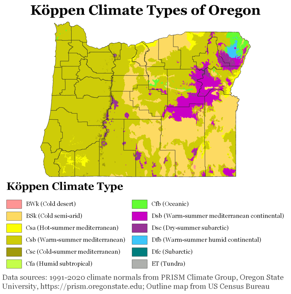
Oregon Köppen Climate Map
More Maps Of US States The Government Doesn’t Want You To See
Finally see our Free Moving To Oregon (OR) Cost Calculator.