
The map of Washington above and the maps below are part of the US government’s now closed NationalAtlas.gov project.
However, they are too good to be lost forever so I’ve preserved them here.
You can learn more about the project and why it was closed down here.
Satellite Map Of Washington

General Washington State Facts
Demonym: Washingtonian
State Abbreviation: WA
Year Admitted To US: 1889
State Number (Out of 50): 42nd
State Capital: Olympia
Total Area: 71,298 sq mi (184,661 km2)
State Area Ranking (Out of 50): 18th
Highest Point: Mount Rainier – 14,417 ft (4394 m)
Lowest Point: 0 ft (0 m)
State Website: https://access.wa.gov/
List of Interstate Highways In Washington
- I-5
- I-82
- I-90
- I-205
- I-405
- I-705
- I-182
List of US Highways In Washington
- US 101
- US 12
- US 195
- US 197
- US 2
- US 295
- US 395
- US 410
- US 730
- US 830
- US 99
List of Toll Roads In Washington
- I-405 (Express Toll Lanes)
- SR 167 (HOT Lanes)
Did you known State Route 20 is the longest road in Washington at 436.13 mi (701.88 km).
Washington County Map

Washington County Map With Important Cities & Towns

You can see more Washington county maps here.
Washington Population Density Map

Washington Population Facts
State Population: 7,812,880
State Population Rank (out of 50): 13th
Population Density: 118/sq mi (45/km2)
Population Density Rank (out of 50): 22nd
Top 10 Cities In Washington
- Seattle: 755,078
- Spokane: 229,447
- Tacoma: 222,906
- Vancouver: 196,442
- Bellevue: 151,574
- Kent: 133,378
- Everett: 111,180
- Spokane Valley: 108,235
- Renton: 104,491
- Federal Way: 97,701
Washington Income & Taxes
Median Household Income: 89,430
Household Income Rank (out of 50): 10th
Top Marginal State Income Tax Rate: 7.00%
Average Sales Tax Rate*: 9.38%
Average Property Tax Rate*: 0.87%
* Note theses vary from city to city within the state.
Map of Washington Lakes & Rivers

Largest Lake In Washington: Lake Roosevelt 125 (sq mi)
Longest River In Washington: Columbia River 1,243 miles (2,000 km)
Washington Annual Precipitation Map

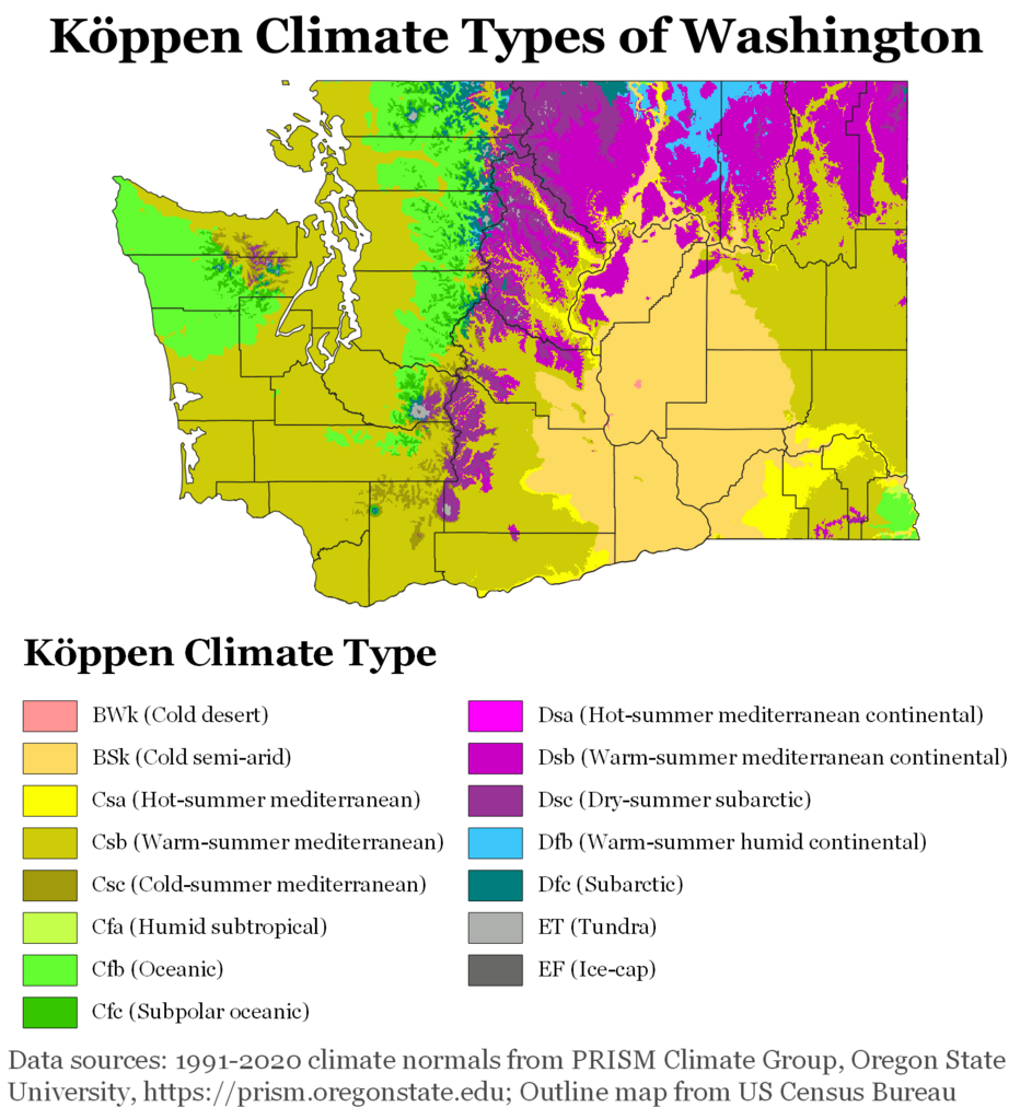
Washington Köppen Climate Map
More Maps Of US States The Government Doesn’t Want You To See
Finally see our Free Moving To Washington (WA) Cost Calculator.