
The map of Utah above and the maps below are part of the US government’s now closed NationalAtlas.gov project.
However, they are too good to be lost forever so I’ve preserved them here.
You can learn more about the project and why it was closed down here.
Satellite Map Of Utah

General Utah State Facts
Demonym: Utahn
State Abbreviation: UT
Year Admitted To US: 1896
State Number (Out of 50): 45th
State Capital: Salt Lake City
Total Area: 84,897 sq mi (219,882 km2)
State Area Ranking (Out of 50): 13th
Highest Point: Kings Peak – 13,534 ft (4125 m)
Lowest Point: 2,000 ft (610 m)
State Website: https://www.utah.gov/
List of Interstate Highways In Utah
- I-15
- I-70
- I-80
- I-84
- I-215
List of US Highways In Utah
- US 163
- US 189
- US 40
- US 450
- US 491
- US 530
- US 630
- US 666
- US 91
List of Toll Roads In Utah
- Adams Avenue Parkway
- I-15 (Express Lanes)
Did you known State Route 24 is the longest road in Utah at 160.243 mi (257.886 km).
Utah County Map

Utah County Map With Important Cities & Towns

You can see more Utah county maps here.
Utah Population Density Map

Utah Population Facts
State Population: 3,417,734
State Population Rank (out of 50): 30th
Population Density: 42/sq mi (16/km2)
Population Density Rank (out of 50): 40th
Top 10 Cities In Utah
- Salt Lake City: 209,593
- West Valley City: 134,470
- West Jordan: 114,908
- Provo: 113,343
- St. George: 104,578
- Orem: 95,519
- Sandy: 91,943
- Lehi: 90,227
- Ogden: 87,267
- South Jordan: 84,528
Utah Income & Taxes
Median Household Income: 95,800
Household Income Rank (out of 50): 2nd
Top Marginal State Income Tax Rate: 4.65%
Average Sales Tax Rate*: 7.25%
Average Property Tax Rate*: 0.57%
* Note theses vary from city to city within the state.
Map of Utah Lakes & Rivers

Largest Lake In Utah: Great Salt Lake 1700 (sq mi)
Longest River In Utah: Colorado River 1,450 miles (2,330 km)
Utah Annual Precipitation Map

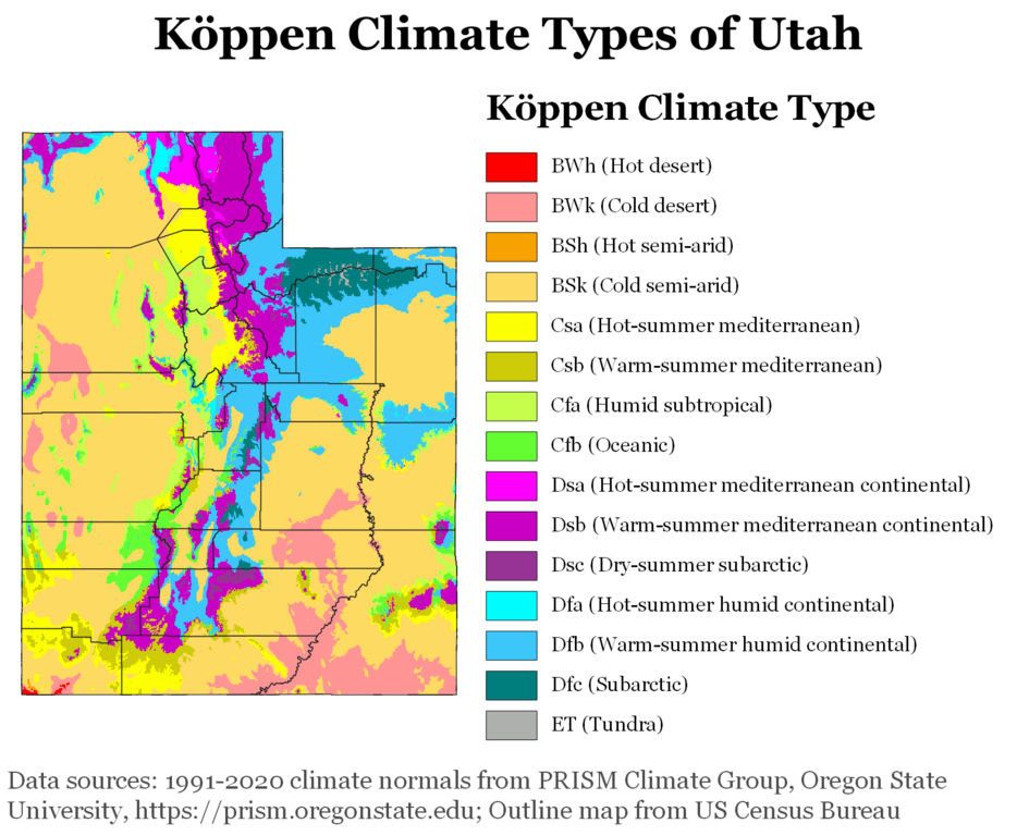
Utah Köppen Climate Map
More Maps Of US States The Government Doesn’t Want You To See
Finally see our Free Moving To Utah (UT) Cost Calculator.