
One of CIA’s oldest and most recognizable intelligence publications, The World Factbook, has sunset. The World Factbook served the Intelligence Community and the general public as a longstanding, one-stop basic reference about countries and communities around the globe.
Link to the History of The World Factbook.
Where is Italy? Location Map

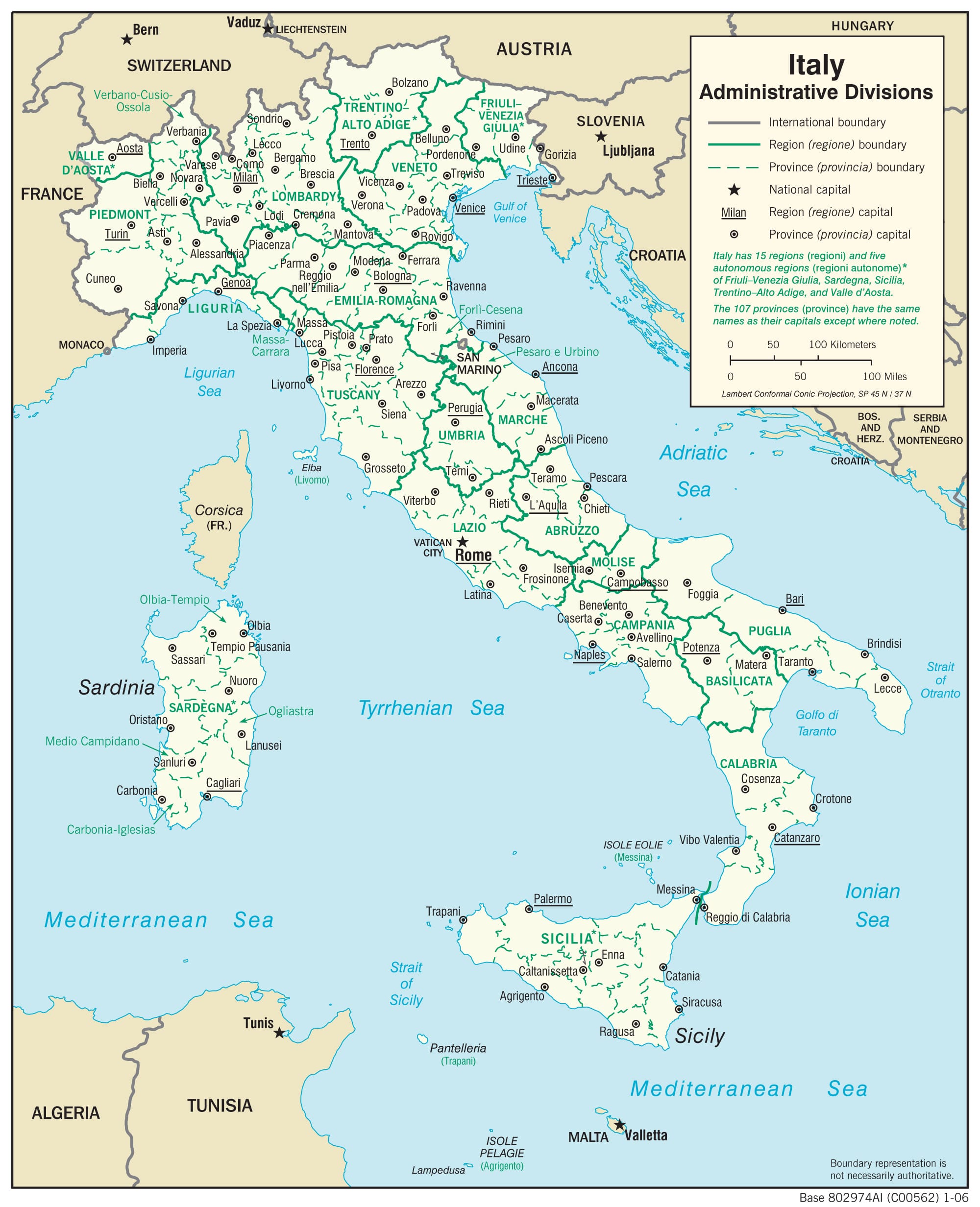
Administrative Map Of Italy
Physiography Map of Italy
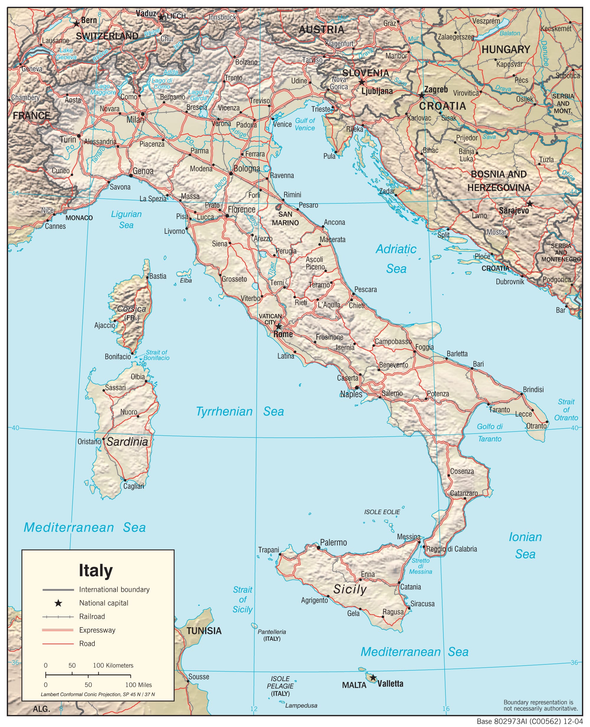
Transportation Map of Italy
Italy Facts
Full Official Name: Italian Republic
Demonym: Italian
Flag:

Area
Total Area: 301,340 km²
Total Land Area: 294,140 km²
Total Water Area: 7,200 km²
Demographics
Population: 60,964,931
Population Growth Rate: -0.08% (2024 est.)
Largest City: Rome (Population: 2,860,009)
Ethnic Groups: Italian (includes small clusters of German-, French-, and Slovene-Italians in the north, Albanian-Italians, Croat-Italians, and Greek-Italians in the south)
Languages: Italian (official), German (parts of Trentino-Alto Adige region are predominantly German-speaking), French (small French-speaking minority in Valle d’Aosta region), Slovene (Slovene-speaking minority in the Trieste-Gorizia area), Croatian (in Molise)
Religions: Christian 80.8% (overwhelmingly Roman Catholic with very small groups of Jehovah’s Witnesses and Protestants), Muslim 4.9%, unaffiliated 13.4%, other 0.9% (2020 est.)
Economy
Currency: Euro
Real GDP at Purchasing Power Parity ($ PPP): $3.097 trillion (2023 est.)
GDP per capita (PPP): $52,700 (2023 est.)
Exports Value Per Year: $793.589 billion (2023 est.)
Biggest Export Partners: Germany 12%, US 11%, France 10%, Spain 5%, UK 4% (2022)
Imports Value Per Year: $756.154 billion (2023 est.)
Biggest Import Partners: Germany 14%, France 8%, China 8%, Netherlands 5%, Spain 5% (2022)
Government
Type: parliamentary republic
Capital City: Rome (Population: 2,860,009)
Other Facts
Time Zone: UTC+1 (CET), UTC+2 (CEST) (DST)
Country Code: IT
Internet TLD: .it
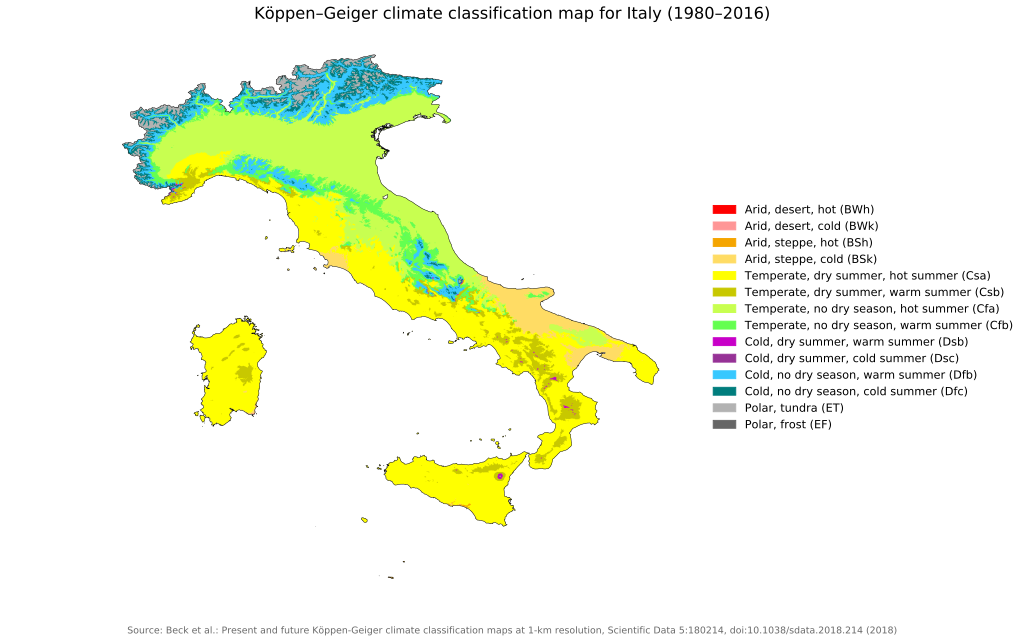
Climate Map of Italy
Topographic Map of Italy

Flag Map Of Italy

Odd Shape?
Italy was included in my list of The 17 Oddest Shaped Countries In The World & How They Came To Be.
Italy’s shape is famously odd because it closely resembles a boot, complete with a heel, toe, and even the island of Sicily as a ball it’s kicking.
This unusual and iconic shape results from millions of years of geological activity, primarily involving tectonic movements, mountain building, volcanoes, and erosion.
Here’s a clear breakdown of how Italy came to look this way:
What’s Odd About Italy’s Shape?
- Italy is unusually long and narrow, extending prominently into the Mediterranean Sea.
- It curves sharply south-eastward, giving it a distinctive boot-like appearance.
- It includes well-defined features:
- The “heel” (Apulia)
- The “toe” (Calabria)
- The island of Sicily at its tip.
How Italy’s Odd Shape Came to Be:
Tectonic Plate Activity (Colliding Continents):
- Italy lies near the collision zone between the African and Eurasian tectonic plates.
- As these plates moved and collided over millions of years, the land crumpled, folded, and rose to form mountains, creating a curved peninsula.
Mountain Building (Alps and Apennines):
- The collision formed the Alps in the north and the Apennines running down Italy’s center.
- The Apennines curve dramatically, giving Italy its characteristic bend.
Volcanic Activity:
- Italy has several volcanoes (Mount Etna, Vesuvius, Stromboli) that significantly shaped southern Italy, especially Sicily.
- Volcanic eruptions built up new landforms and islands, adding detail to Italy’s intricate coastline.
Erosion and Sea-Level Changes:
- Rivers, oceans, wind, and glaciers carved Italy’s coasts, creating jagged, irregular edges.
- Sea-level fluctuations submerged some areas and exposed others, enhancing the peninsula’s distinctive shape.
More maps of Italy:
- Lighthouse Map of Italy
- Map of Italy in 1084
- Most Common Surnames in Italy By Region
- Area Transferred To France From Italy In The Paris Peace Treaty Of 1947
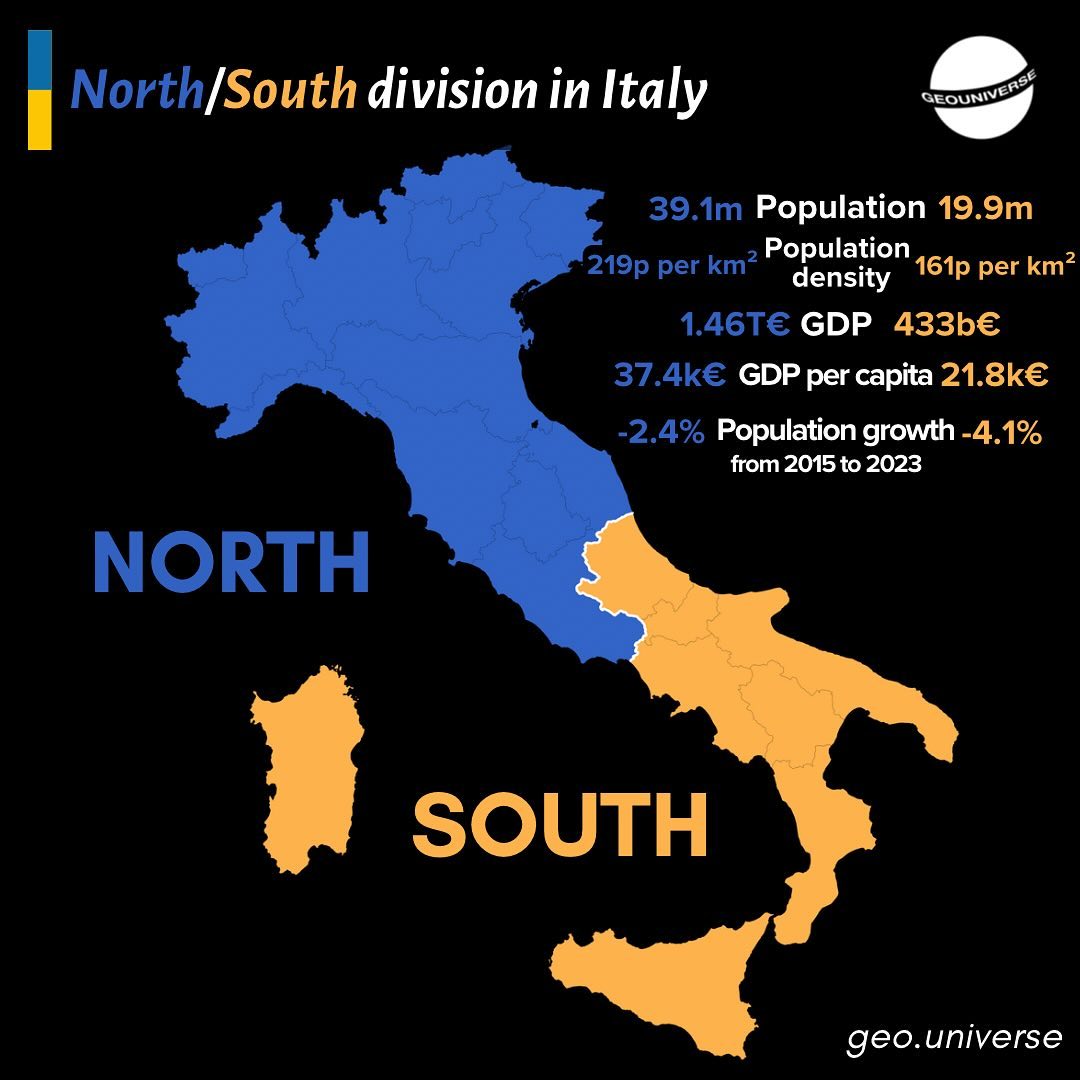
North vs South Italy
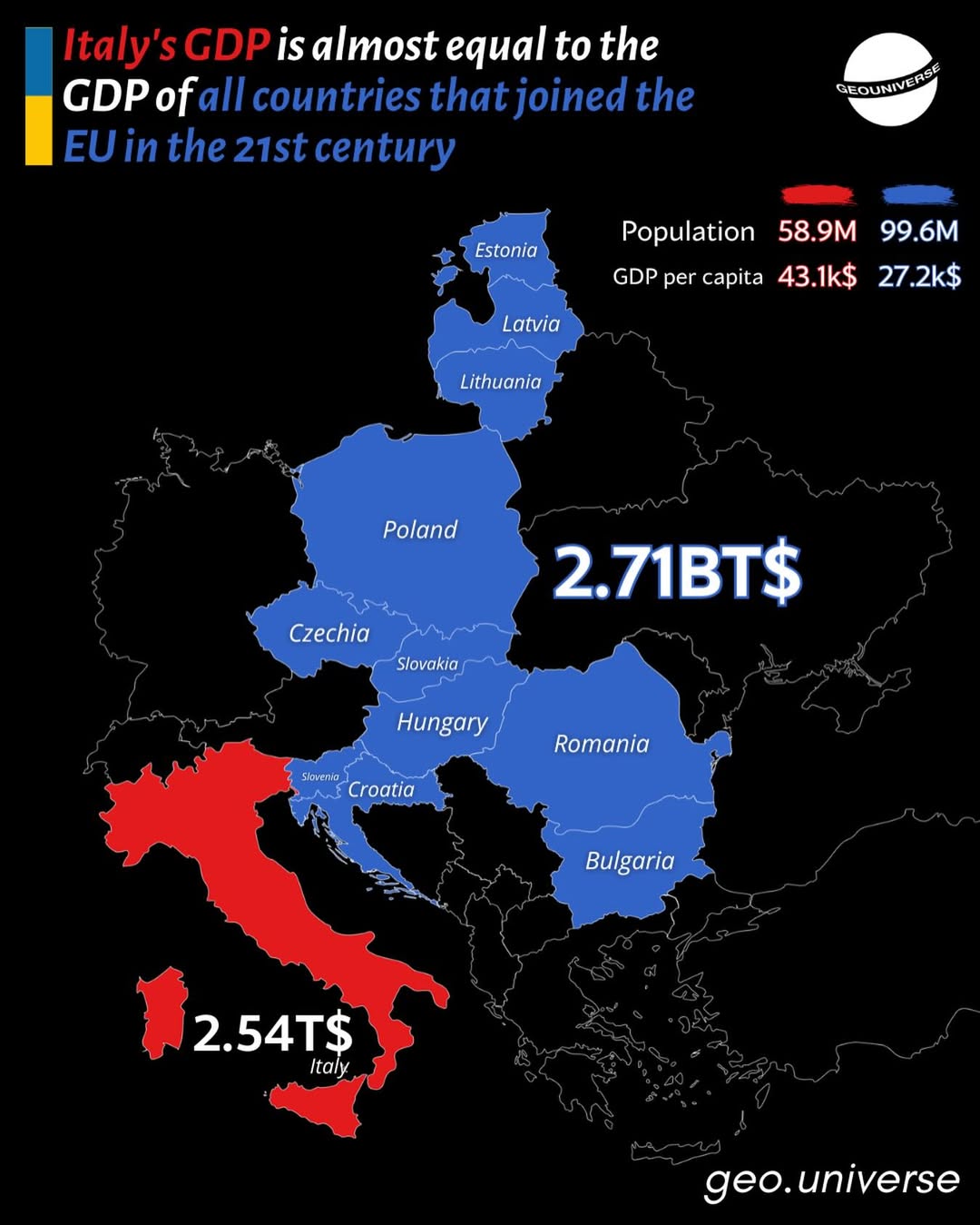
Italy vs New EU
Read More About Italy
- Official Italy Website
- Italy On The CIA World Factbook
- Italy On Wikipedia
- Italy On National Geographic Kids
- Italy On Britannica
See other country maps here.