Brilliant Maps

Making Sense Of The World, One Map At A Time

  • BOOK!
  • Newsletter
  • Board Games
  • Posters
  • Scratch Maps

Interactive Pangaea Map With Modern International Borders

Last Updated: April 21, 2023 35 Comments

Click To Get My 10 Best Brilliant Maps For Free:

Interactive Pangaea Map With Modern International Borders

Screenshot, see full interactive version below

One of our most popular maps is Pangaea With Current International Borders.

However, while it’s without a doubt an amazing map, many users have commented that they wished that you could see the whole world.

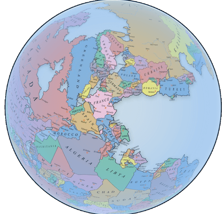
Fortunately, Massimo Pietrobon via Tomas Slavkovsky from Melown, has done just that, creating a fully interactive Pangaea map with modern international borders that allows you to explore the whole earth.

You can have a play around with it below:

[Read more…]

Filed Under: World Maps

If European Borders Were Drawn By DNA Instead Of Ethnicity

Last Updated: March 3, 2023 74 Comments

Click To Get My 10 Best Brilliant Maps For Free:

If European Borders Were Drawn By DNA Instead Of Ethnicity

Map originally found on reddit

The map above shows what the borders of Europe, the Middle East and North Africa might look like if they were based on the dominant Y-DNA haplogroup rather than ethnicity and/or any other political considerations.

[Read more…]

Filed Under: Border, Europe

Flat Earth “Globe”

Last Updated: March 3, 2023 3 Comments

Click To Get My 10 Best Brilliant Maps For Free:

Flat Earth

Map created by John Krygier at Making Maps

The map above shows what a “Globe” of the Earth would look like if the Earth was flat.

Most people accept that maps use a variety of projection techniques to render the 3D Earth onto a 2D plane. And that globes show us what the Earth really looks like.

However, flat Earth societies don’t buy this whole 3D/2D divide and believe (seriously or not) that the Earth is flat.

[Read more…]

Filed Under: Other Tagged With: globe

Luxembourg Is Not A Microstate!

Last Updated: March 3, 2023 7 Comments

Click To Get My 10 Best Brilliant Maps For Free:

Luxembourg Is Not A Microstate!

Map created by reddit user issoweilsosoll

The map above shows how big Luxembourg is compared to Singapore, Andorra, Malta, Liechtenstein, San Marino, Monaco, and the Vatican.

[Read more…]

Filed Under: Europe Tagged With: comparison

Map Showing How Airlines Divert Flights Around Syrian Airspace

Last Updated: March 3, 2023 1 Comment

Click To Get My 10 Best Brilliant Maps For Free:

flights avoid Syria

Map from flightradar24

The interactive map from flightradar24 above shows live flight locations for commercial civilian aircraft around the world.

When you zoom in on Syria you can see how airlines choose route their planes to avoid all Syrian and most Iraqi airspace.

[Read more…]

Filed Under: Other Tagged With: flights

Map of Europe, 1500 AD

Last Updated: March 3, 2023 10 Comments

Click To Get My 10 Best Brilliant Maps For Free:

Map of Europe, 1500 AD

Map created by reddit user Yetkinler

The map above shows the patchwork of kingdoms, principalities, bishoprics, duchies, republics, cities, sultanates, etc. in and around Europe in 1500 CE/AD.

[Read more…]

Filed Under: Europe, History

The Border Between Belgium & The Netherlands at Baarle-Hertog/Baarle-Nassau

Last Updated: March 3, 2023 3 Comments

Click To Get My 10 Best Brilliant Maps For Free:

The Border Between Belgium & The Netherlands at Baarle-Hertog/Baarle-Nassau

The map above shows the incredibly strange and complex border between Belgium and the Netherlands at Baarle-Hertog (Belgium) / Baarle-Nassau (Netherlands).

[Read more…]

Filed Under: Border, Europe Tagged With: Belgium, Netherlands

Indian Borders According To Google Maps India vs USA

Last Updated: March 3, 2023 1 Comment

Click To Get My 10 Best Brilliant Maps For Free:

Indian Borders According To Google.co.in vs Google.com

Map found via reddit

The map above shows how Google.co.in shows India’s borders compared to how Google.com shows them.

[Read more…]

Filed Under: Asia Tagged With: India

Travel Time from Ancient Rome

Last Updated: March 3, 2023 1 Comment

Click To Get My 10 Best Brilliant Maps For Free:

Travel Time from Ancient Rome

Map created by Stanford University’s ORBIS project

The map above is an Isochrone map which shows how long it would have taken someone to travel from Rome to the farthest reaches of the Roman Empire at its peak (roughly 200 CE/AD).

Travelling within the core of the Empire could have be done in under a week, but travelling all the way to the fringes would have taken someone more than a month.

[Read more…]

Filed Under: Europe, History Tagged With: rome

The First Ordnance Survey Map

Last Updated: March 3, 2023 1 Comment

Click To Get My 10 Best Brilliant Maps For Free:

The First Ordnance Survey Map

The map above, titled An Entirely New & Accurate Survey Of The County Of Kent, With Part Of The County Of Essex was created by William Mudge in 1801 and is regarded at the first official Ordnance Survey map.

[Read more…]

Filed Under: United Kingdom Tagged With: Ordnance Survey

  • « Previous Page
  • 1
  • …
  • 126
  • 127
  • 128
  • 129
  • 130
  • …
  • 155
  • Next Page »


Product Reviews · World Atlas · Settlers of Catan · Risk · Game of Thrones · Coloring Books
Globes · Monopoly · Star Wars · Game of Life · Pandemic · Ticket To Ride · Drinks Cabinets
US Locations · UK Locations· Fleet Management
Copyright © 2026 · Privacy Policy · Fair Use, Attribution & Copyright · Contact Us
Follow Us: Newsletter · Facebook · Youtube · Twitter · Threads · BlueSky · LinkedIn · Instagram · Pinterest · Flipboard