The Berlin Conference ran from 15 November 1884 to 26 February 1885. Fourteen states sent delegates: Austria-Hungary, Belgium, Denmark, France, Germany, Italy, the Netherlands, Portugal, Russia, Spain, Sweden-Norway, the Ottoman Empire, the United Kingdom and the United States.
Not one African was in the room.
Contrary to the popular picture, the delegates did not sit down with a ruler and divide the continent.
The General Act they signed did three main things:
- it recognised King Leopold II’s Congo Free State and declared the Congo basin a free-trade zone,
- it guaranteed free navigation on the Congo and Niger rivers, and
- it laid down the rule of “effective occupation,” a power could only claim a stretch of African coast if it actually administered it and notified the others.
That last clause is what turned a slow land-grab into a sprint. In 1880 Europeans controlled roughly a tenth of Africa. By 1914 only Ethiopia and Liberia were still independent.
The maps below, by Instagram mapmakers @hunmapper and @forummapping, show what each of the European players wanted out of the Scramble and what they ended up with.
They are a great starting point, but “what they wanted” is a slippery idea, ambitions changed between 1884 and 1914, and some of these maps show a dream, some show a formal claim, and one or two show something closer to a rumour.
So under each country we have checked the maps against the historical record.
The British Empire
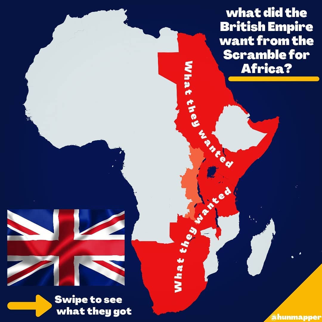
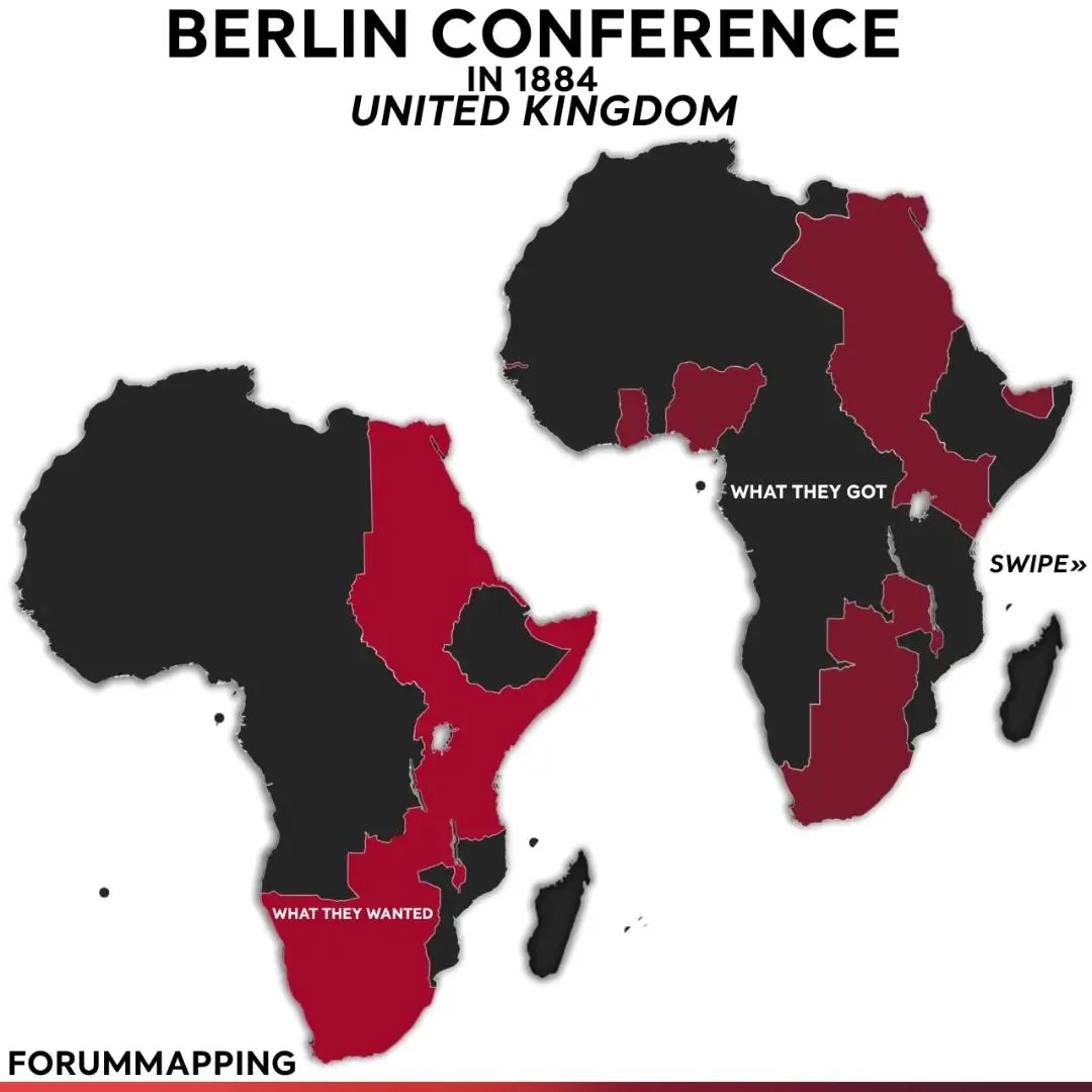
What they wanted
The red belt running from Egypt to the Cape is the famous “Cape to Cairo” dream, most associated with Cecil Rhodes and the colonial administrator Harry Johnston: an unbroken line of British territory, eventually with a railway and telegraph running its full length.
Britain’s underlying priorities were strategic rather than territorial.
It occupied Egypt in 1882 to protect the Suez Canal and the route to India, which in turn meant controlling the Nile all the way to its source, which in turn meant Uganda and Kenya.
The Somali coast was wanted to feed the garrison at Aden. In the south, the Cape Colony pressed London to annex the Namibian coast and Bechuanaland before anyone else did.
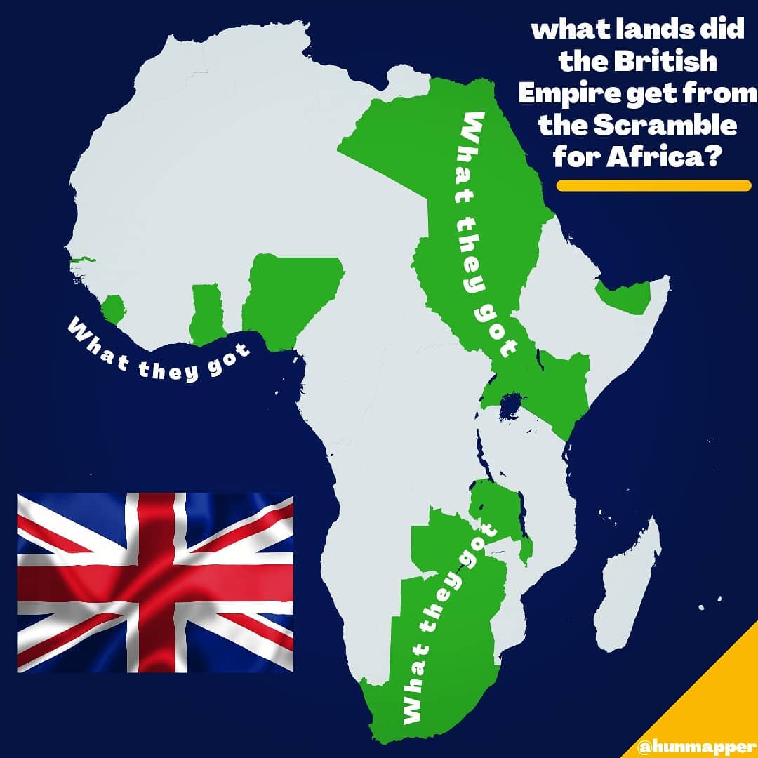
What they got
Almost all of it. Egypt (occupied 1882), the Anglo-Egyptian Sudan (reconquered 1896-99), British Somaliland (1884-87), Uganda (1894), British East Africa – later Kenya (1895), Nyasaland (1891), Northern and Southern Rhodesia through Rhodes’s British South Africa Company (chartered 1889), Bechuanaland (1885) and, after the Boer War of 1899-1902, the whole of South Africa. Britain also picked up Zanzibar as a protectorate in 1890 and built a second empire in West Africa that is nowhere on the “wanted” map: Nigeria, the Gold Coast, Sierra Leone and the Gambia.
The one gap was German East Africa, which sat squarely across the route. Britain only closed it when Tanganyika became a British mandate in 1919, and the all-red line then survived until Sudan’s independence in 1956.
The Cape to Cairo railway was never finished.
Map check
The map is a fair picture of the Rhodes-era ambition, but it is a late-1880s ambition, not a Berlin Conference position.
At Berlin, Britain’s main aims were to keep the Niger (it did) and to stop Leopold and France from taking the Congo mouth (it half did).
Namibia on the “wanted” map is defensible – the Cape wanted it – but London was caught flat-footed when Germany annexed it in 1884 and never seriously contested it.
The lighter strip through eastern Congo is a nice detail: in May 1894 Britain leased a 25 km-wide corridor from Lake Albert to Lake Tanganyika from Leopold to complete the Cape-to-Cairo link, then dropped it within three months after Germany objected.
The biggest thing missing from the “wanted” map is West Africa, Nigeria alone held more people than the whole of the eastern belt, and Britain secured it through the Royal Niger Company without ever drawing it on a dream map.
France
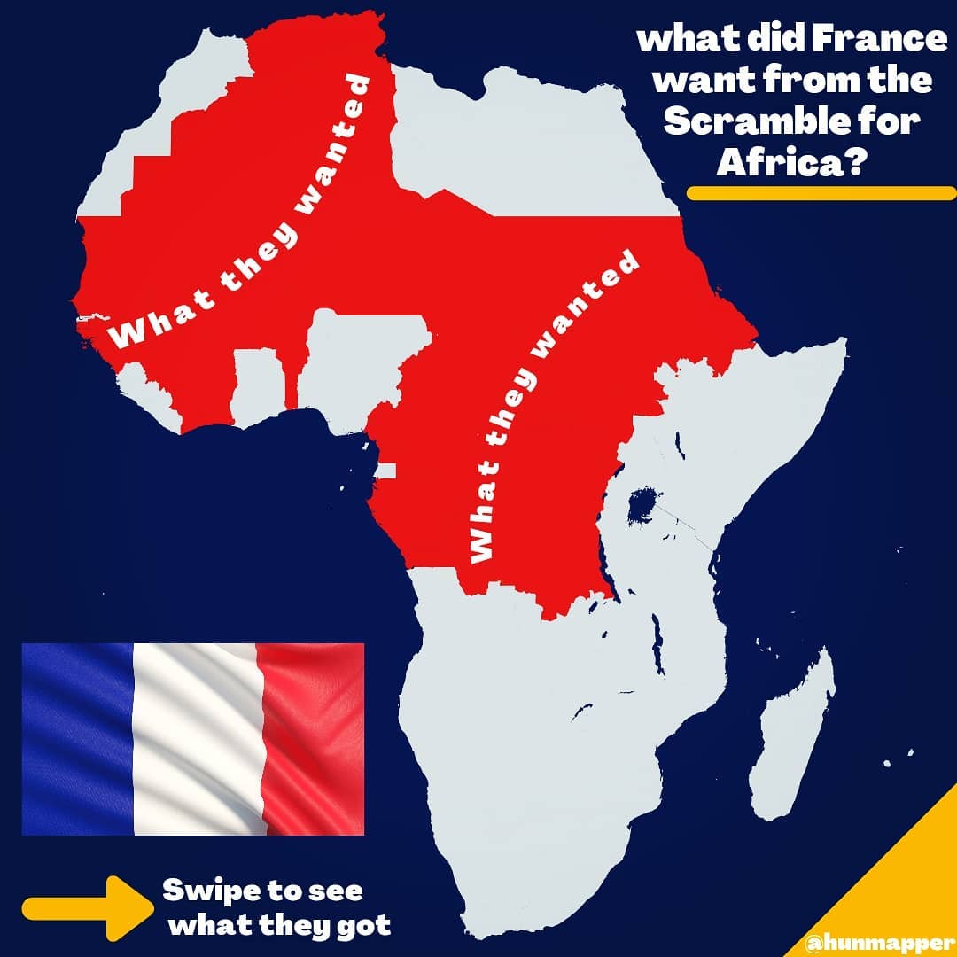
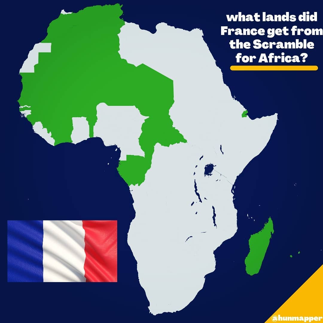
What they wanted
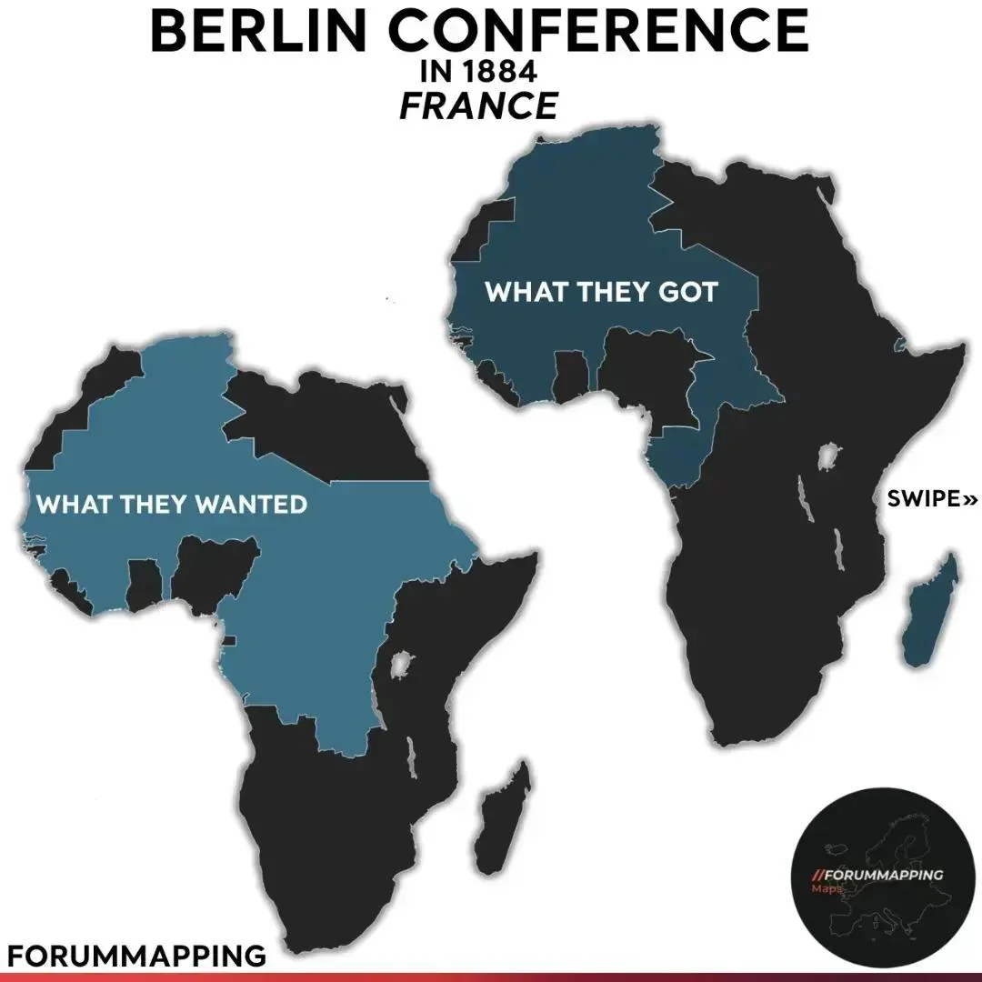
France started the Scramble with the strongest position in Africa, Algeria since 1830, Senegal since the 1600s, and a toehold in Gabon, and wanted to join them up.
The plan was a single contiguous empire from the Mediterranean to the Congo, with Morocco and Tunisia added on either side of Algeria.
The more ambitious version, pursued through the 1890s, added a west-to-east axis across the Sahel to the Nile: a French line from Dakar to Djibouti that would cut across Britain’s north-south one.
That is what the red reaching to the Nile on the map represents. Captain Marchand’s expedition was sent to plant the flag at Fashoda on the upper Nile for exactly this reason.
What they got
By area, more than anyone else.
Tunisia became a protectorate in 1881, Morocco in 1912. French West Africa (Senegal, French Sudan, Guinea, Ivory Coast, Dahomey, Upper Volta, Niger, Mauritania) was federated in 1895 and French Equatorial Africa (Gabon, Middle Congo, Ubangi-Shari, Chad) in 1910. Madagascar was conquered in 1896, Djibouti secured in 1888, and after the First World War France also took most of Togo and Cameroon from Germany.
The total came to roughly 35 per cent of the continent, though a great deal of it was Sahara.
What France did not get was the Nile.
Marchand reached Fashoda in July 1898; Kitchener arrived two months later with a much larger force fresh from crushing the Mahdists at Omdurman, and after a tense stand-off Paris backed down.
The 1899 Anglo-French agreement fixed the Nile-Congo watershed as France’s eastern limit.
France had also lost Egypt – the Suez Canal was a French project and France shared control of Egyptian finances until 1882, but it declined to join the British intervention that year and never got back in.
In 1904 it formally traded any claim on Egypt for a free hand in Morocco.
Map check
Both maps are accurate in outline.
The “got” map is a snapshot of around 1912-14: it includes Morocco (1912) but not the Togo and Cameroon mandates (1919-22), which is a reasonable place to draw the line.
The “wanted” map arguably under-states French ambition by leaving Egypt out, and Libya is correctly excluded – France had conceded Libya to Italy in 1902 as the price of Italian acquiescence in Morocco.
The German Empire
What they wanted
Germany is the odd one out, because the man who called the Berlin Conference did not particularly want colonies. “My map of Africa lies in Europe,” Bismarck said in 1888.
He took the four German protectorates in 1884-85 largely for domestic political reasons and as bargaining chips against Britain.
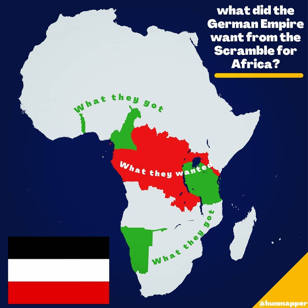
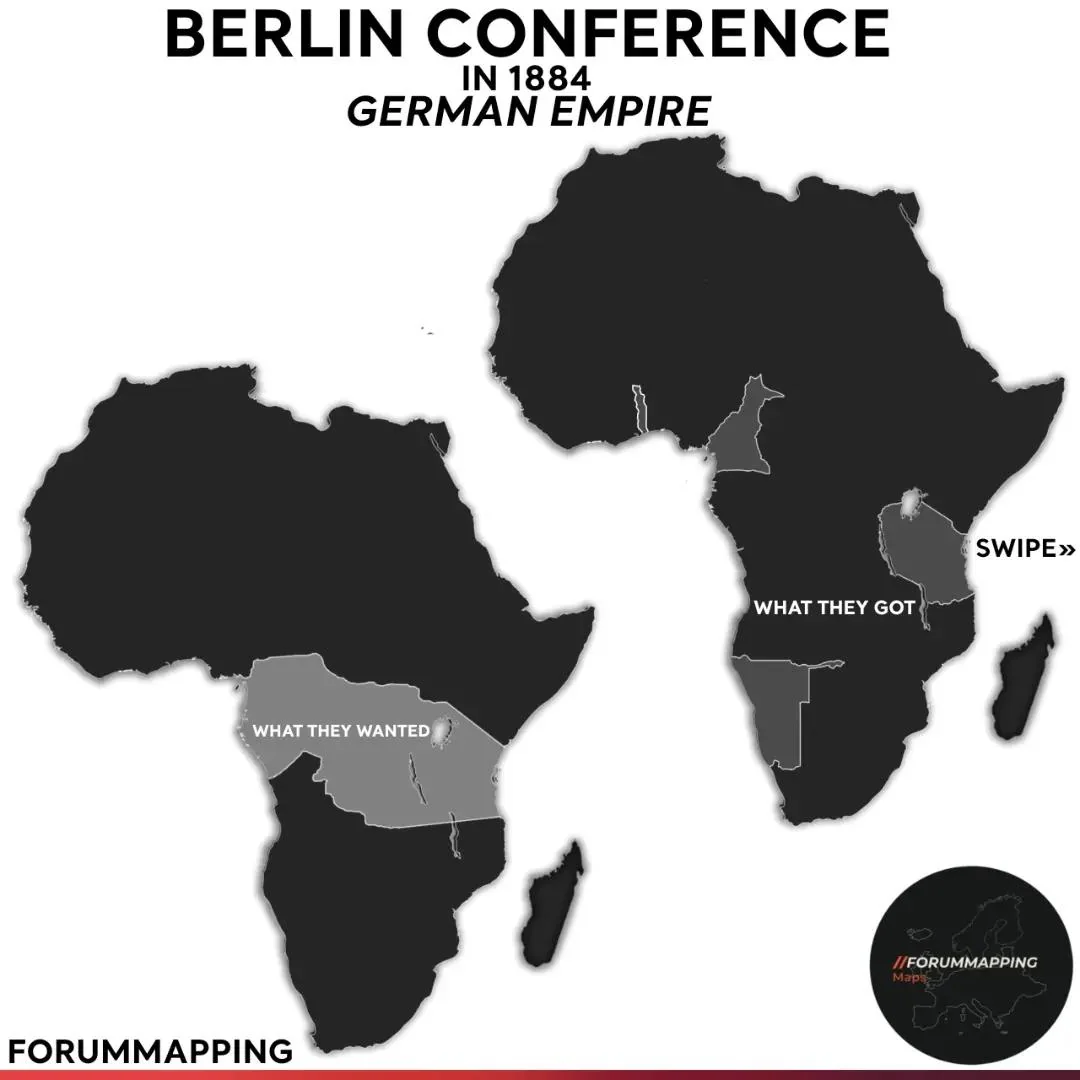
The red area in the map – the Congo basin from Kamerun to the Great Lakes – is Mittelafrika, a later Wilhelmine dream of a solid German block across the middle of the continent, joining Kamerun to German East Africa by absorbing the Belgian Congo and slices of Angola and Mozambique.
Germany signed secret agreements with Britain in 1898 and 1913 to carve up Portugal’s colonies if Portugal ever defaulted on its debts, and Mittelafrika was written into Germany’s war aims in September 1914.
What they got
Four colonies, all claimed within a year: Togoland and Kamerun (July 1884), German South West Africa (declared a protectorate in April 1884 after the merchant Adolf Lüderitz bought the coast at Angra Pequena) and German East Africa, built on the treaties Carl Peters signed in late 1884 and chartered the day after the Berlin Conference closed.
The 1890 Heligoland-Zanzibar Treaty tidied up the edges: Germany gave up Witu and its claims on Zanzibar in return for Heligoland and the Caprivi Strip.
The last addition came in 1911, when France handed over 275,000 km² of “Neukamerun” to end the Agadir crisis. At that point German Africa covered around 2.7 million km², five times the size of Germany itself.
It all went in 1919. The Treaty of Versailles stripped Germany of every colony: Tanganyika went to Britain, Ruanda-Urundi to Belgium, South West Africa to South Africa, and Togo and Cameroon were split between Britain and France.
Map check
The green “got” areas are drawn at their 1914 peak – you can see the Neukamerun extension reaching down to the Congo river and Rwanda-Burundi attached to German East Africa.
That is correct. The red “wanted” is the one anachronism: Mittelafrika was never a Berlin Conference claim and was not formally articulated until the 1890s-1900s.
But as a picture of what Germany would have taken if it had won the First World War, it is right.
Portugal
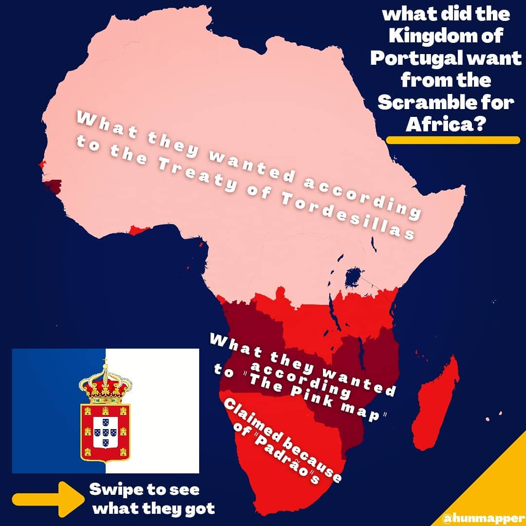
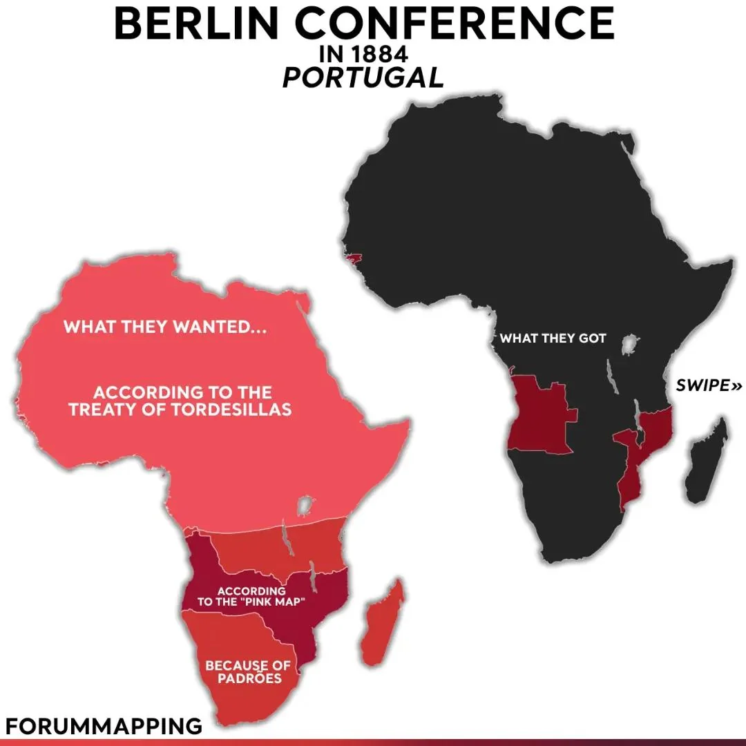
What they wanted
Portugal had been in Africa for four centuries and argued, with some justice, that it had got there first.
The map layers its three claims.
The pale pink is the 1494 Treaty of Tordesillas, by which the Pope divided the non-Christian world between Portugal and Spain and handed Portugal everything east of a line in the Atlantic – including, in theory, all of Africa.
The medium red along the southern coasts is the land Portugal claimed because its navigators had planted padrões – stone crosses – there: Diogo Cão in Angola and Namibia in the 1480s and Bartolomeu Dias at the Cape in 1488.
And the dark red belt is the serious one: the Mapa cor-de-rosa, the “Pink Map”, published in 1886 after France and Germany had both signed treaties recognising Portugal’s claim to the land between Angola and Mozambique.
It would have given Portugal a coast-to-coast empire across modern Zambia, Zimbabwe and Malawi.
Portugal’s other big claim is not on the map: the mouth of the Congo.
The Anglo-Portuguese Treaty of February 1884, which recognised Portuguese sovereignty over both banks of the river, was the immediate trigger for the Berlin Conference. France, Germany and Leopold all objected and the treaty was never ratified.
What they got
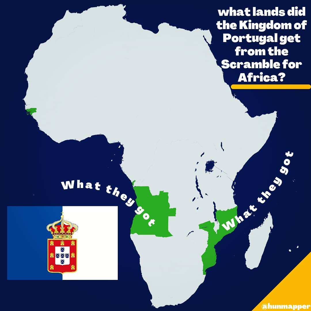
Angola, including Cabinda, and Mozambique – the two ends of the Pink Map without the middle – plus Portuguese Guinea, Cape Verde and São Tomé and Príncipe.
The effective-occupation rule agreed at Berlin was aimed squarely at Portugal’s “historic rights”: it meant that having planted a cross in 1488 counted for nothing against a British company with a garrison.
When Portuguese expeditions moved into the Shire Highlands and Mashonaland in 1889, Britain issued the Ultimatum of 11 January 1890 demanding withdrawal.
Portugal, with no navy to speak of, gave way within a day. The humiliation helped bring down the monarchy twenty years later. At the Congo mouth it kept only Cabinda and the south bank; Leopold took the north bank.
Map check
The Tordesillas claim is a mapmaker’s flourish rather than an actual 1884 position – no Portuguese diplomat asked for the Sahara – though it is a fair joke about the “historic rights” argument.
The Pink Map and the padrões claims are real.
The “got” map leaves out Cape Verde and São Tomé, which is forgivable at this scale, and the Congo-mouth claim, which is the one omission that matters, since it is why the conference happened at all.
Belgium (or rather, Leopold II)
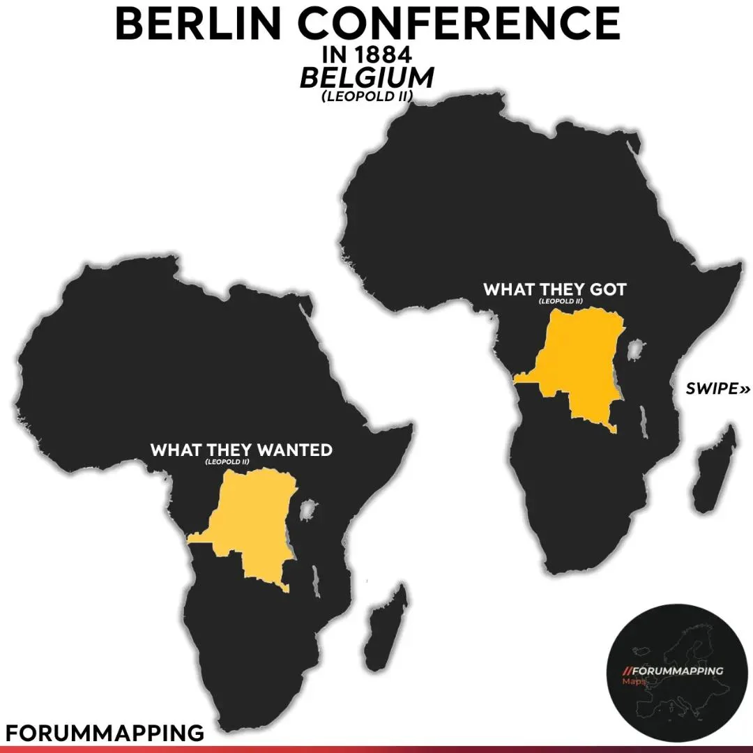
What they wanted
Belgium wanted nothing.
Its parliament had no interest in colonies and said so.
Its king was another matter. Leopold II had spent years looking for a colony – he considered the Philippines, Formosa, Argentina and Fiji – before settling on the Congo.
Working through a series of front organisations with philanthropic names (the International African Association, then the International Association of the Congo) and paying Henry Morton Stanley to sign some 450 treaties with Congolese chiefs between 1879 and 1884, he built a private claim to the entire basin.
His great diplomatic coup was getting the United States to recognise his association’s flag in April 1884, before the conference began. Germany followed in November, Britain in December.
What they got
The Congo Free State: around 2.3 million km², 76 times the size of Belgium, recognised by the powers during the conference and declared in July 1885 as Leopold’s personal possession, not a Belgian colony!
He then expanded it. The 1891 Stairs expedition seized Katanga, killing its ruler Msiri.
In 1894 Leopold leased the Lado Enclave on the upper Nile from Britain.
The rubber regime he ran produced atrocities on such a scale that the Belgian state was shamed into taking the colony off him in 1908. Belgium added Ruanda-Urundi as a mandate after the First World War.
Map check
Wanted equals got, which is the point: Leopold was the conference’s outright winner.
The map uses the modern DRC outline for both, which quietly includes Katanga (not secured until 1891) and leaves out the Lado Enclave (held 1894-1910).
It also, reasonably, labels this “Belgium (Leopold II)” – but it is worth being clear that in 1885 Belgium as a state owned nothing in Africa, and did not want to.
Italy
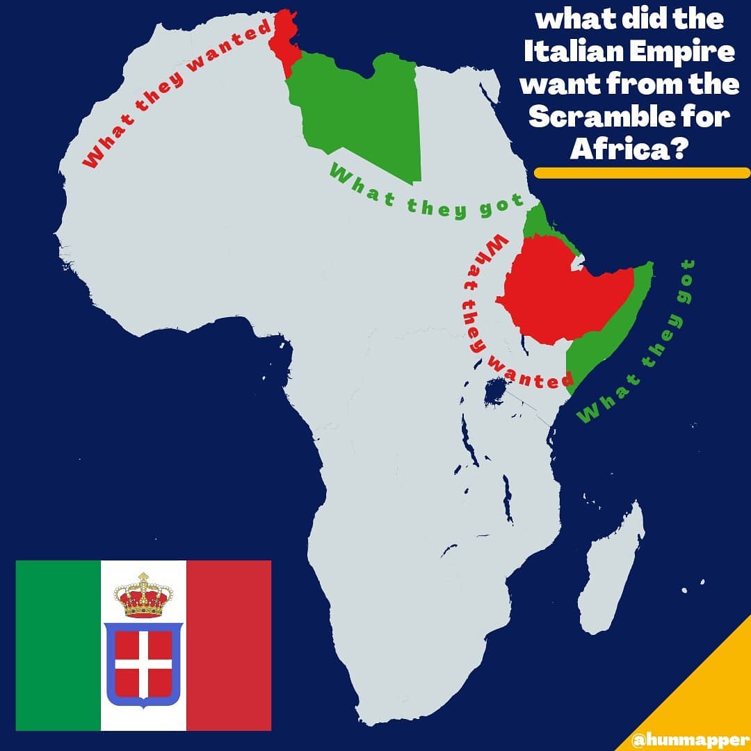
What they wanted
Italy, unified only in 1861, came to the Scramble late and with a chip on its shoulder.
Its first target was Tunisia, a short sail from Sicily and home to far more Italian settlers than French ones.
France grabbed it in 1881 – the schiaffo di Tunisi, the “slap of Tunis” – which drove Italy into the Triple Alliance with Germany and Austria the following year.
Its second target was Ethiopia.
Italy bought the port of Assab in 1869, took Massawa in 1885 with British encouragement, and in 1889 signed the Treaty of Wuchale with Menelik II, which in its Italian text (but not its Amharic one) made Ethiopia an Italian protectorate.
What they got
Eritrea (a colony from 1890), Italian Somaliland (protectorates from 1889, the Benadir coast bought from Zanzibar in 1905) and, much later, Libya. The Ethiopian project ended at Adwa on 1 March 1896, where Menelik’s army destroyed an Italian force of 17,000, killing around 6,000.
It was the only decisive defeat of a European power by an African state during the Scramble, and Italy was forced to recognise Ethiopian independence outright.
As a consolation prize France agreed in 1902 to let Italy have Libya, which Italy took from the Ottomans in the war of 1911-12 – though it took until the 1930s to control the interior.
Italy finally conquered Ethiopia in 1936, but that was Mussolini’s war, not the Scramble.
Map check
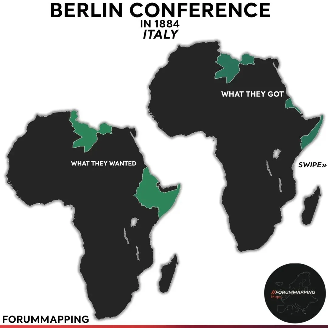
Accurate, with one point of interpretation. @hunmapper treats Libya as “got” and Tunisia as “wanted”; @forummapping (below) treats Libya as “wanted” and leaves Tunisia out.
Both are defensible – Italy coveted Libya from the 1880s onwards – but the hunmapper version tells the better story, since Tunisia was the loss that shaped everything Italy did afterwards.
Neither map shows Jubaland, the slice of Kenya that Britain handed to Italian Somaliland in 1924.
Spain
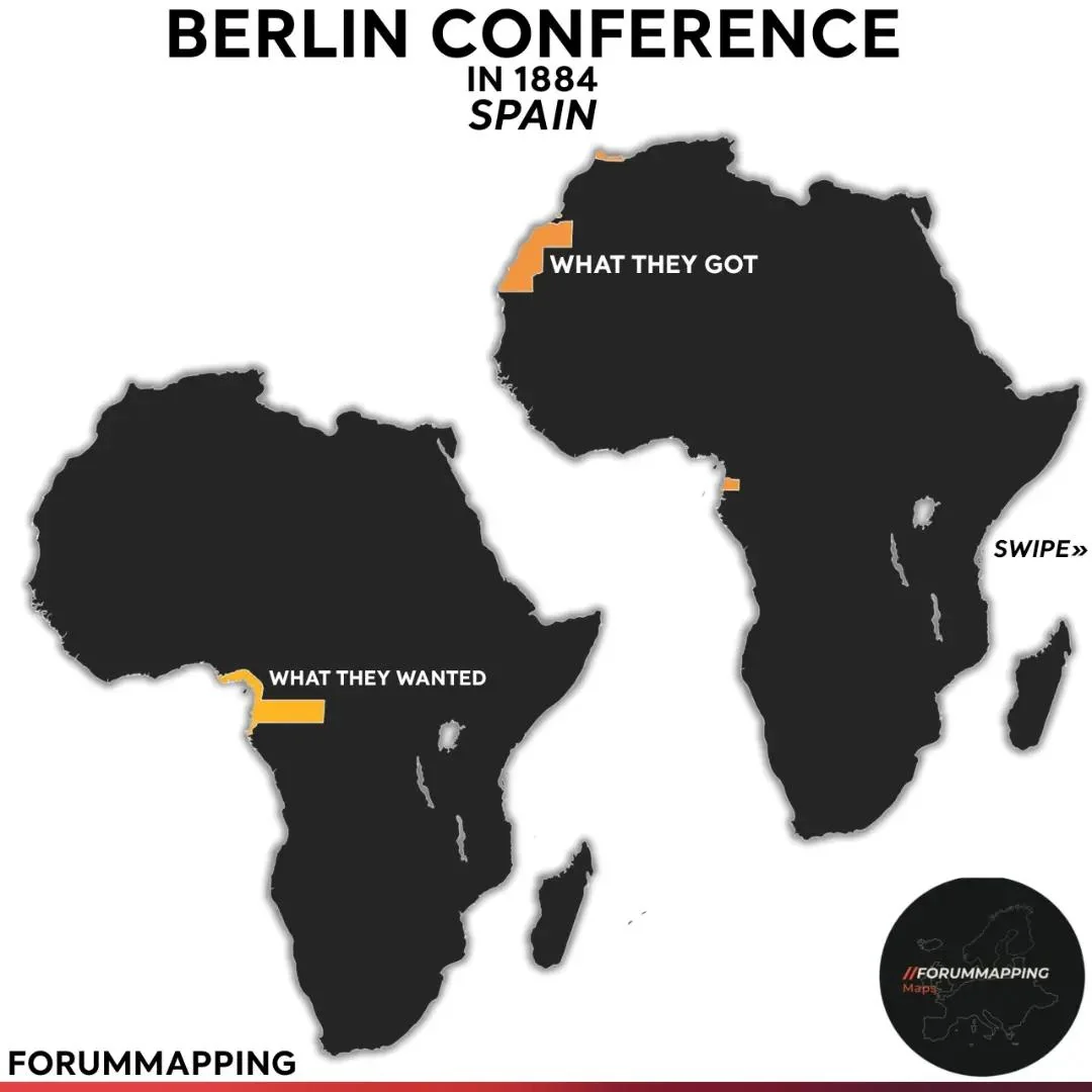
What they wanted
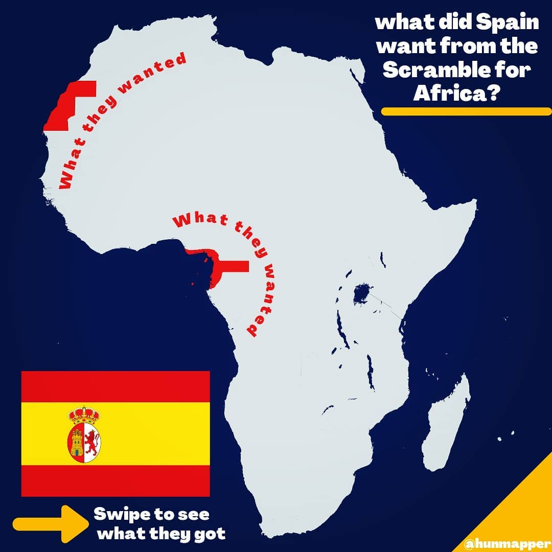
Spain’s claims rested on old paper.
Under the 1778 Treaty of El Pardo Portugal had ceded it the island of Fernando Po (Bioko) and trading rights on the mainland coast between the Niger and Ogooué rivers.
On that basis Spain claimed around 300,000 km² of the Gulf of Guinea hinterland, stretching east as far as the Ubangi river.
In the north-west it wanted the Saharan coast opposite the Canaries, and it declared a protectorate over Río de Oro on 26 December 1884 – in the middle of the Berlin Conference – with Ceuta, Melilla and a claim on Ifni giving it a foothold in Morocco proper.
What they got
Not much.
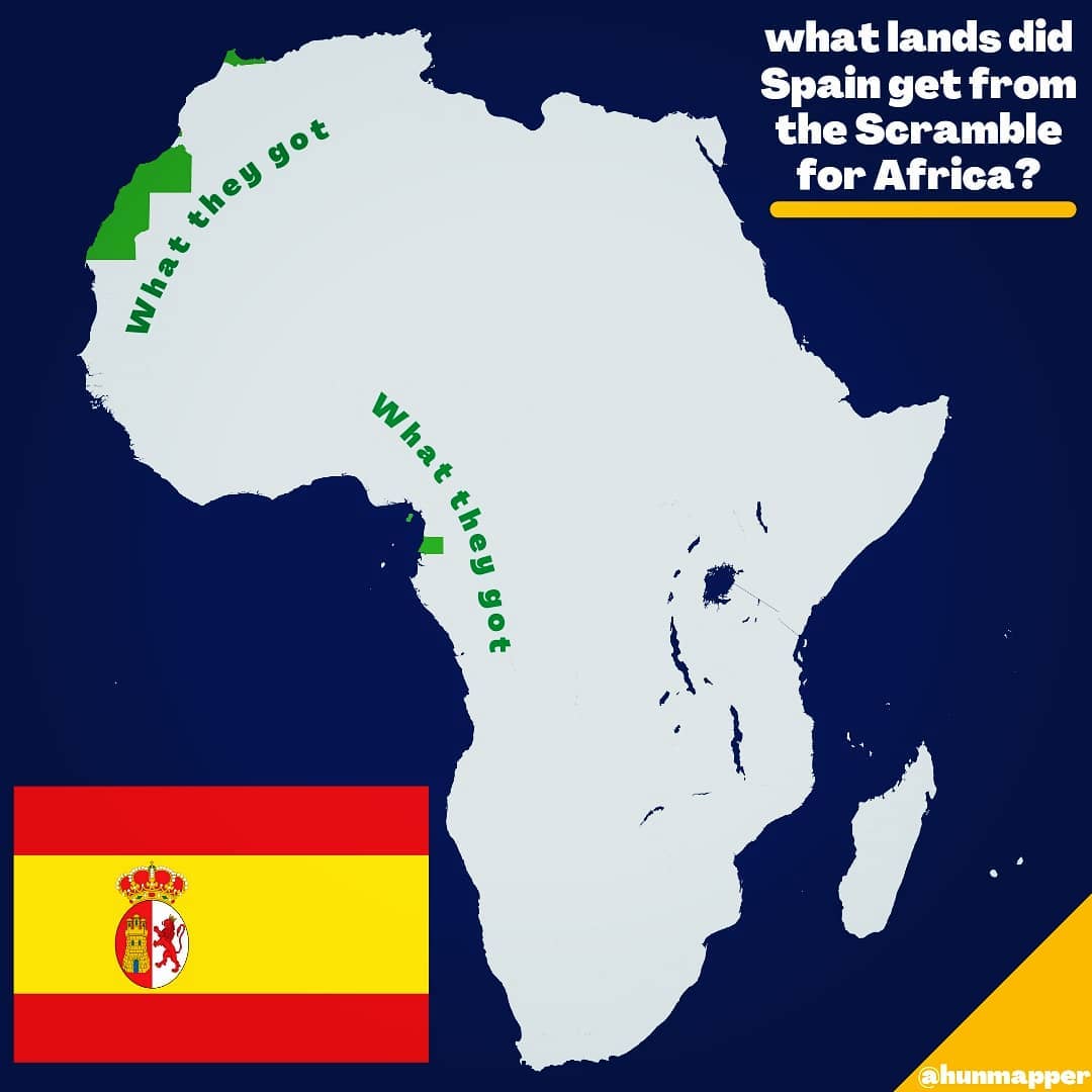
The 1900 Treaty of Paris with France gave Spain Río Muni, 26,000 km² against the 300,000 claimed, plus Bioko and a few islets – the whole of Spanish Guinea was smaller than Belgium.
France kept the rest. In the Sahara Spain did better on paper, with Río de Oro and Saguia el Hamra (about 266,000 km² of desert) confirmed in 1900-1912, but it was so unenthusiastic that in 1898 it tried to sell the territory.
After 1912 it also got the northern strip of Morocco as its zone of the French protectorate, which cost it a brutal war in the Rif in the 1920s.
Map check
Both maps actually understate Spain’s Guinea claim: the red blob on the hunmapper map is a modest extension of Río Muni, whereas the 1884-1900 claim reached several hundred kilometres further inland.
The forummapping version (below) leaves Western Sahara off the “wanted” map altogether, which is odd given that Spain claimed it during the conference itself. The “got” maps are right for around 1912.
The Ottoman Empire
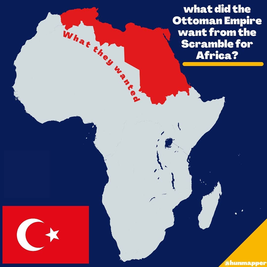
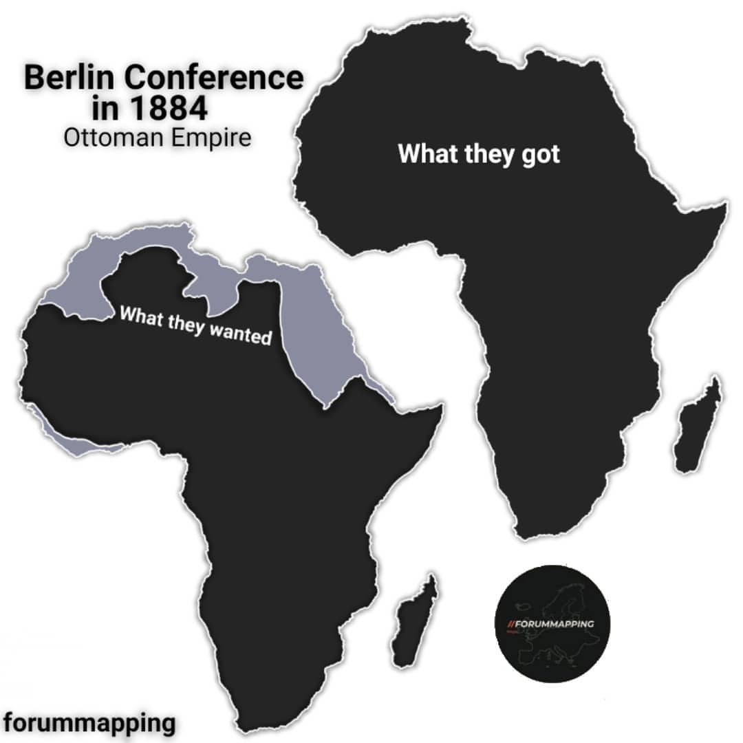
What they wanted
The Ottomans were the one participant trying to hold on rather than grab.
On paper, in 1880, the Sultan was sovereign over the whole of North Africa east of Algeria: Tunisia, Tripolitania and Cyrenaica (under direct rule since 1835), Egypt (an autonomous khedivate under Ottoman suzerainty) and, through Egypt, the Sudan and the Red Sea ports of Suakin, Massawa and Zeila. What Istanbul wanted from the Scramble was recognition of that – and in particular of its claim to the Saharan hinterland south of Libya, towards Lake Chad.
What they got
Nothing, and then lost the rest.
France took Tunisia in 1881. Britain occupied Egypt in 1882. The Mahdists took Khartoum on 26 January 1885, while the conference was still sitting.
Italy took Massawa the following month, Britain took Zeila and Berbera, and Ethiopia took Harar in 1887.
The Ottomans did mount one real counter-push: between 1908 and 1912 they planted garrisons deep in the Sahara at Tibesti, Borkou and Kanem – a genuine “Ottoman scramble”.
It was undone when Italy invaded Libya in 1911, and France mopped up the Saharan outposts by 1914. By the outbreak of the First World War the Ottoman Empire had no territory in Africa at all.
Map check
The hunmapper map is a reasonable picture of nominal Ottoman Africa around 1880 and makes the right point.
The forummapping version has one puzzling feature: a shaded strip along the Atlantic coast of West Africa from roughly Western Sahara to Guinea, for which we can find no historical basis.
Neither map shows the one thing the Ottomans actively pushed for – the Saharan hinterland south of Libya – which was their only real move in the Scramble.
Russia
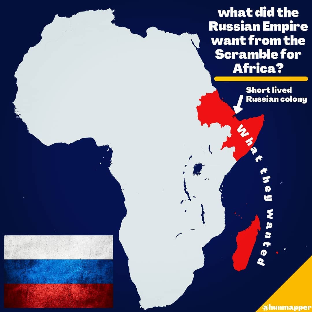
What they wanted
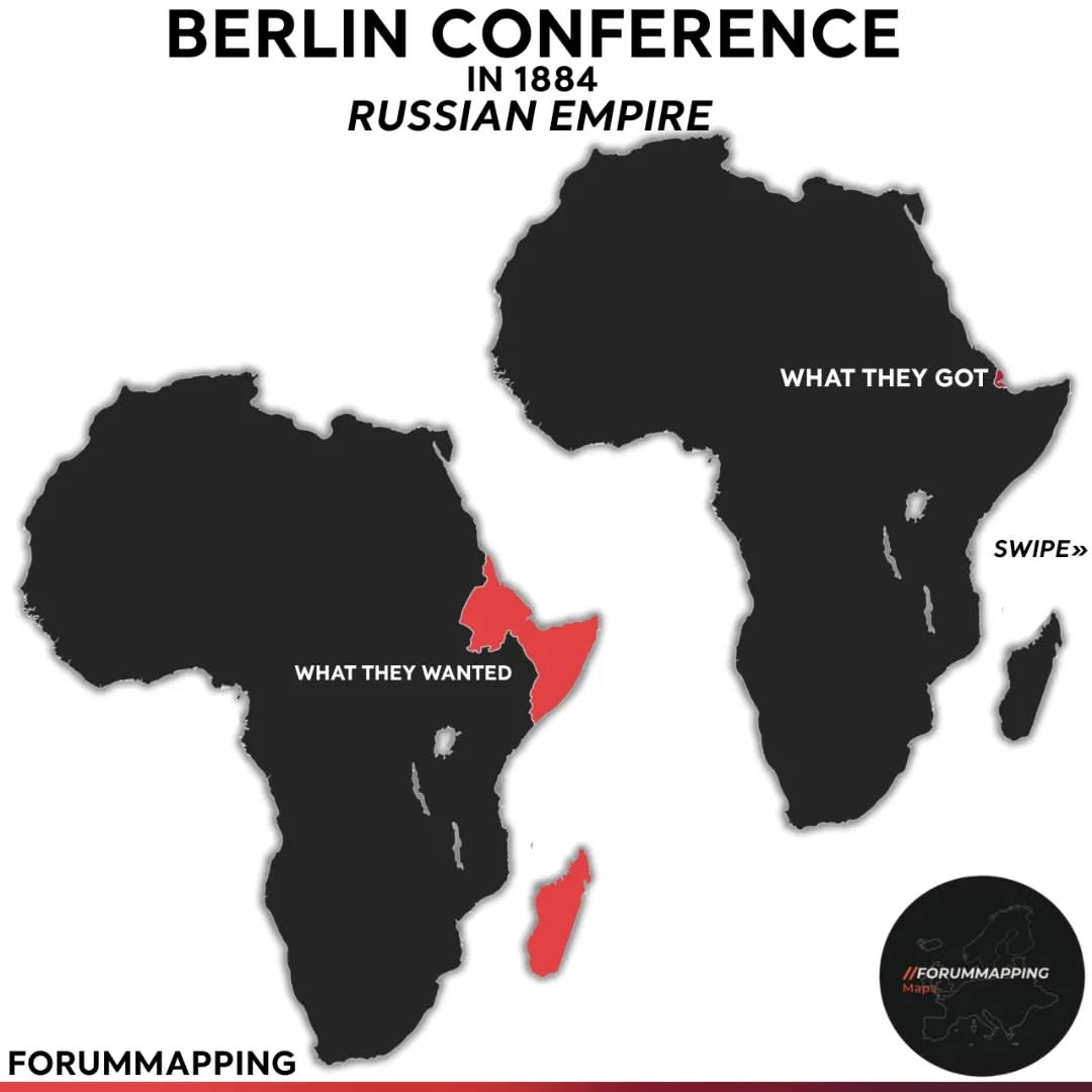
Russia had no colonial programme in Africa, but it did have an interest: Ethiopia, the continent’s other Orthodox Christian empire.
Russian officers served as advisers to Menelik, a Russian Red Cross mission treated the wounded after Adwa, and in 1898 a Russian colonel, Artamonov, marched with an Ethiopian force to the White Nile and raised the Russian flag beside the Ethiopian one at the height of the Fashoda crisis.
The Madagascar claim on the map goes back much further – Peter the Great sent two frigates to establish a base there in 1723, and they were turned back by a storm.
What they got
Three weeks of Sagallo.
In January 1889 a Russian adventurer, Nikolai Ashinov, landed with 165 Terek Cossacks at an abandoned Egyptian fort on the Gulf of Tadjoura, in what is now Djibouti, and proclaimed the colony of “New Moscow”.
The territory was French. On 5 February a French cruiser and three gunboats arrived, issued an ultimatum, and when Ashinov refused to leave, shelled the fort.
Six colonists were killed. The Russian government, which had not authorised the expedition, disowned him, and Ashinov was packed off to internal exile.
Map check
The “wanted” area badly overstates things.
Russia never claimed Ethiopia – the whole point of its policy was to keep Ethiopia independent of Italy – and it never claimed the Somali coast.
Madagascar was a 1723 idea. The best way to read the map is as a sphere of Russian interest, not of Russian ambition. The Sagallo dot is the one thing on either map that is literally correct.
Austria-Hungary
What they wanted
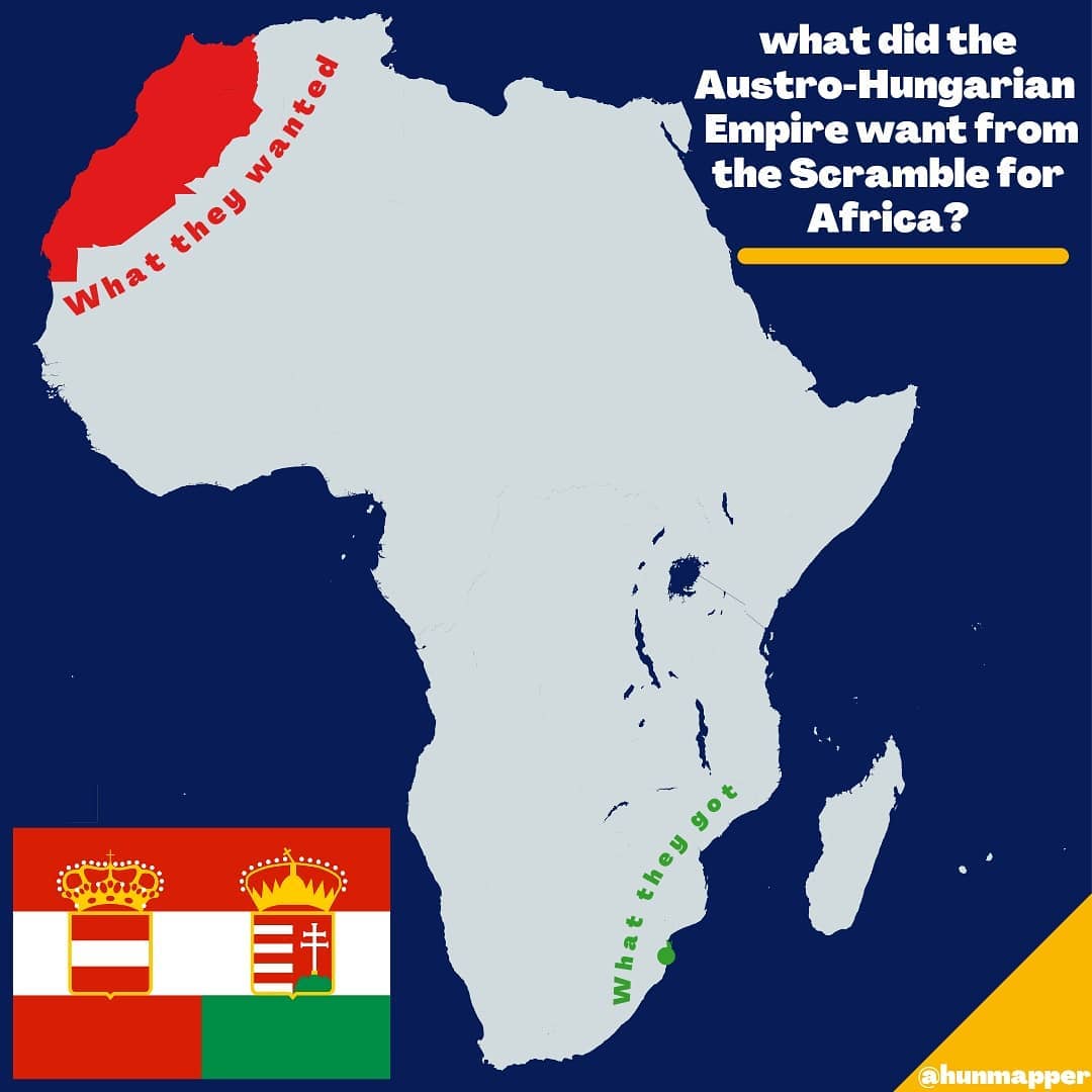
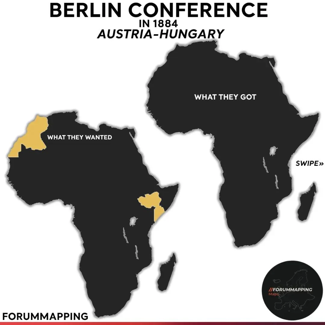
Officially, nothing.
Austria-Hungary attended Berlin because it was a great power and great powers attended.
Its delegate, Count Imre Széchényi, asked for and got one thing: free docking rights for Austrian ships in the African ports of the other powers.
Vienna’s actual African record is a list of near-misses.
In 1777-81 the Austrian Asiatic Company of Trieste, under the adventurer William Bolts, ran a trading colony at Delagoa Bay in Mozambique until the Portuguese expelled it.
The Novara expedition of 1857 surveyed Socotra with an eye to a coaling station. And in 1898-99 Spain offered to sell Río de Oro to Austria-Hungary; the Emperor and the foreign minister were keen, but the government refused to put up the money and the deal collapsed.
What they got
Nothing. The green dot on the hunmapper map appears to be Delagoa Bay, but that colony ended a century before the Scramble.
Map check
This is the weakest pair of maps in the set.
We can find no evidence of an Austro-Hungarian claim on Morocco – at the 1906 Algeciras conference on Morocco, Austria backed Germany diplomatically but asked for nothing.
The nearest real episode is the Río de Oro offer, which concerned Western Sahara rather than Morocco.
The Ethiopia and Somalia shading on the forummapping map may be an echo of some failed Austrian commercial ventures on the Somali coast, but there was never a claim.
The honest version of Austria-Hungary’s map would be a blank continent with a dot at Delagoa Bay and a question mark over Río de Oro.
The Netherlands
What they wanted
The Dutch had already had their African empire and lost it.
The Cape Colony, Dutch since 1652, was taken by Britain in 1806; the Dutch Gold Coast forts, including Elmina, were sold to Britain in 1872.
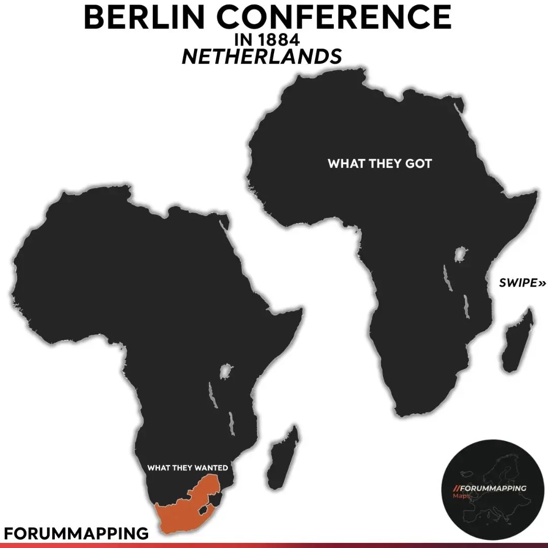
The Hague went to Berlin for one reason, which was commercial: the Nieuwe Afrikaansche Handels-Vennootschap of Rotterdam was the largest European trading house on the Congo, based at Banana at the river’s mouth, and the Netherlands wanted free trade on the river guaranteed. It got that.
The orange area on the map is the Boer republics – the Transvaal and the Orange Free State – and the surrounding Afrikaner-settled country.
Dutch public opinion was passionately pro-Boer, especially during the two Boer Wars.
The Transvaal’s state secretary, Willem Leyds, was a Dutchman; a Dutch company built the Transvaal’s railway to Delagoa Bay in 1894; and when Paul Kruger went into exile in 1900 it was to the Netherlands. But the Dutch government never claimed the republics and could not have held them if it had.
What they got
Nothing, apart from the free-trade clauses.
Map check
“Wanted” is the wrong word for this map. The shaded area is better described as the part of Africa where Dutch was spoken and Dutch sympathies lay. As a map of Dutch sentiment it is fine; as a map of Dutch policy it is fiction.
The scoreboard
Approximate share of Africa’s land area held by each power on the eve of the First World War:
| Power | Share of Africa, c. 1914 | Verdict |
|---|---|---|
| France | ~35% | Got the contiguous empire, lost Egypt and the Nile |
| Britain | ~29% | Got Cape to Cairo (eventually) plus West Africa |
| Germany | ~9% | Four colonies, never Mittelafrika, all gone by 1919 |
| Italy | ~8% | Libya and two coasts; beaten in Ethiopia |
| Belgium (Leopold) | ~8% | Exactly what he wanted |
| Portugal | ~7% | Both ends of the Pink Map, not the middle |
| Spain | ~1% | A tenth of its Guinea claim, plus desert |
| Ottoman Empire | 0% | Lost everything it had |
| Russia | 0% | Three weeks at Sagallo |
| Austria-Hungary | 0% | Docking rights |
| Netherlands | 0% | Free trade on the Congo |
| Independent (Ethiopia, Liberia) | ~4% | – |
By area, France was the big winner; by population, Britain was, with roughly twice as many African subjects.
The real winner of the conference itself was a man who did not attend it and whose country did not want a colony.
And the one party with the most to say about any of it – the roughly 100 million people who lived there – was not asked.



Leave a Reply