
This is just 5 years before the Berlin Conference in 1885 that would launch the so-called “Scramble for Africa,” of full European domination and conquest of the continent.
However, as you can clearly see in the map above European colonization was already well underway at this point.
You can see the comparison in the following simplified map:

In terms of the main powers they included (from the map legend):
European
- France (especially Algeria which became a part of France in 1848)
- Portugal (Portuguese East & West Africa)
- United Kingdom (Cape Colony)
African
- Khedivate of Egypt (autonomous tributary state of the Ottoman Empire)
- Ethiopian Empire (also known as Abyssinia)
- Sokoto Caliphate
- Gaza Empire
- Kingdom of Kongo
- Sultanate of Zanzibar
Here’s a bit more about the African states that existed.
West Africa:
- Sokoto Caliphate (1804–1903)
- Largest state in West Africa, centered in modern-day northern Nigeria.
- Powerful Islamic empire founded by Usman dan Fodio.
- Ashanti Empire (circa 1701–1901)
- Located in modern-day Ghana, known for wealth, sophisticated governance, military power, and gold trade.
- Kingdom of Dahomey (circa 1600–1894)
- Located in present-day Benin, renowned for military strength, particularly the Dahomey Amazons (women warriors), as well as participation in the slave trade.
- Empire of Wassoulou (1878–1898)
- Founded by Samori Touré in what is now Guinea and Mali, noted for fierce resistance to French colonial expansion.
East Africa:
- Ethiopian Empire (Abyssinia)
- Ancient empire, notably independent and politically strong, successfully resisting European colonization under Emperor Menelik II, later famously defeating Italy at Adwa in 1896.
- Sultanate of Zanzibar (1856–1964)
- Wealthy state controlling trade across East Africa, particularly in spices, ivory, and slaves. Zanzibar was an influential trade hub along the Indian Ocean coast.
- Buganda Kingdom (established 14th century)
- Powerful kingdom located within modern Uganda; a center of political and economic influence in East Africa during the 19th century.
Southern and Central Africa:
- Zulu Kingdom (1816–1897)
- Dominant military kingdom in Southern Africa, founded by Shaka Zulu, later resisting British colonization notably during the Anglo-Zulu War (1879).
- Kingdom of Matabeleland (Ndebele Kingdom, 1837–1894)
- Powerful southern African state, located in present-day Zimbabwe, known for military prowess under leaders such as Mzilikazi and Lobengula.
- Merina Kingdom (Madagascar, 1540–1897)
- Centralized and relatively advanced kingdom that unified much of Madagascar, later confronting French colonial ambitions.
North Africa:
- Egypt (Muhammad Ali Dynasty, Ottoman vassal 1805–1882, British occupation post-1882)
- Semi-independent state, strategically important due to the Suez Canal (opened in 1869), undergoing modernization under Muhammad Ali and his successors.
- Mahdist State (1881–1898)
- Emerged the year after this map in Sudan with the rise of Muhammad Ahmad al-Mahdi, challenging Egyptian-British dominance, eventually captured Khartoum (1885).
- Morocco (Alaouite Dynasty)
- Independent Sultanate managing its autonomy despite increasing European pressure, finally becoming a French protectorate in 1912.
Oh, and if you’re wondering what happened after this video may help:
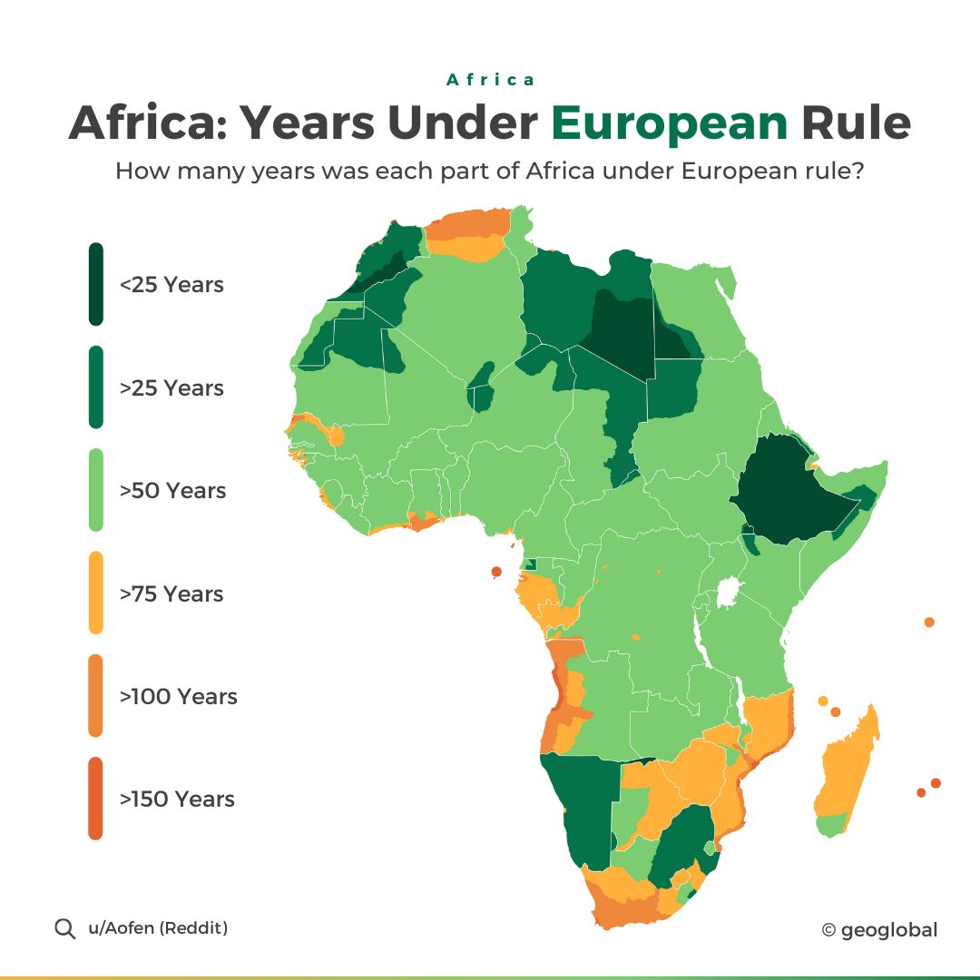
and finally here’s a map showing how long different parts of Africa were under European Rule:
Find this map interesting? Please help by sharing it.


Leave a Reply