Ok so the title is a little confusing but hopefully when you look at the maps it will make a bit more sense.
The first map shows who the reigning British Monarch was when the US state became a state.
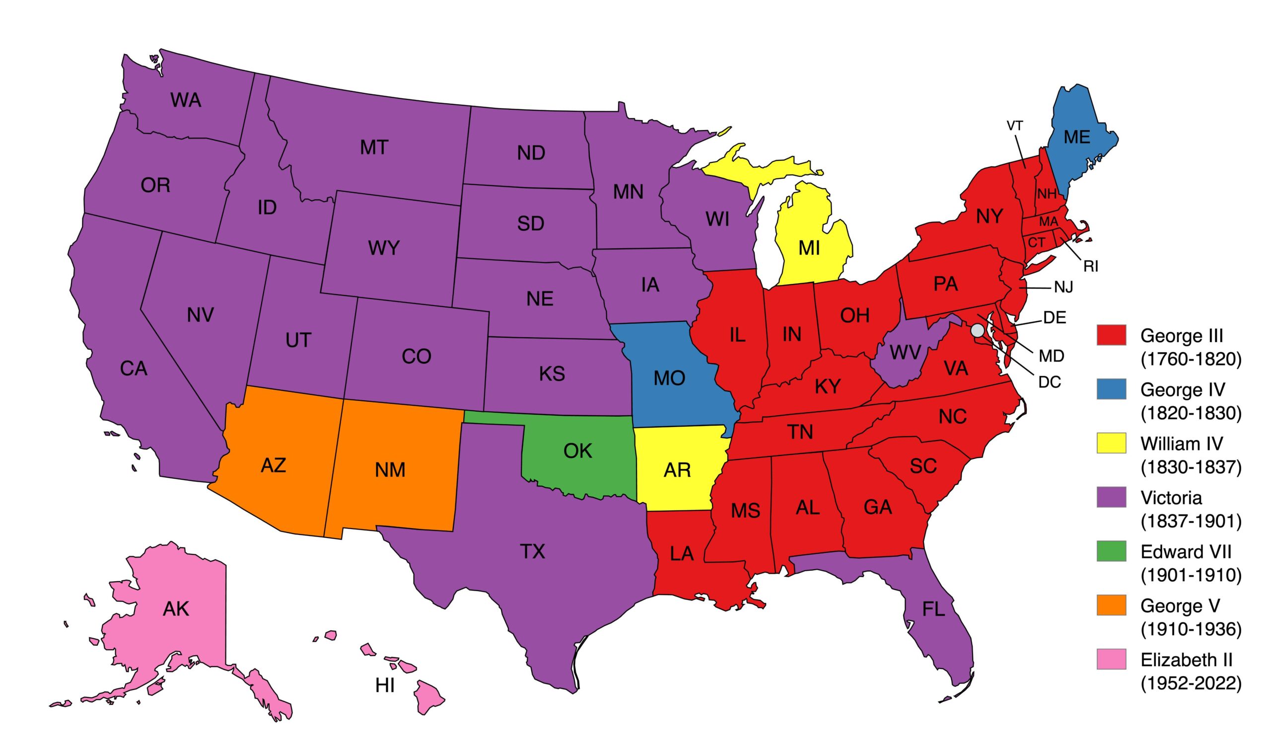
George III (1760–1820)
- Alabama
- Connecticut
- Delaware
- Georgia
- Illinois
- Indiana
- Kentucky
- Louisiana
- Maryland
- Massachusetts
- New Hampshire
- New Jersey
- New York
- North Carolina
- Ohio
- Pennsylvania
- Rhode Island
- South Carolina
- Tennessee
- Vermont
- Virginia
- District of Columbia
George IV (1820–1830)
William IV (1830–1837)
Victoria (1837–1901)
- California
- Colorado
- Florida
- Idaho
- Iowa
- Kansas
- Minnesota
- Montana
- Nebraska
- Nevada
- North Dakota
- Oregon
- South Dakota
- Texas
- Utah
- Washington
- Wisconsin
- Wyoming
- West Virginia
Edward VII (1901–1910)
George V (1910–1936)
Elizabeth II (1952–2022)
and Here’s one for the state of Germany:
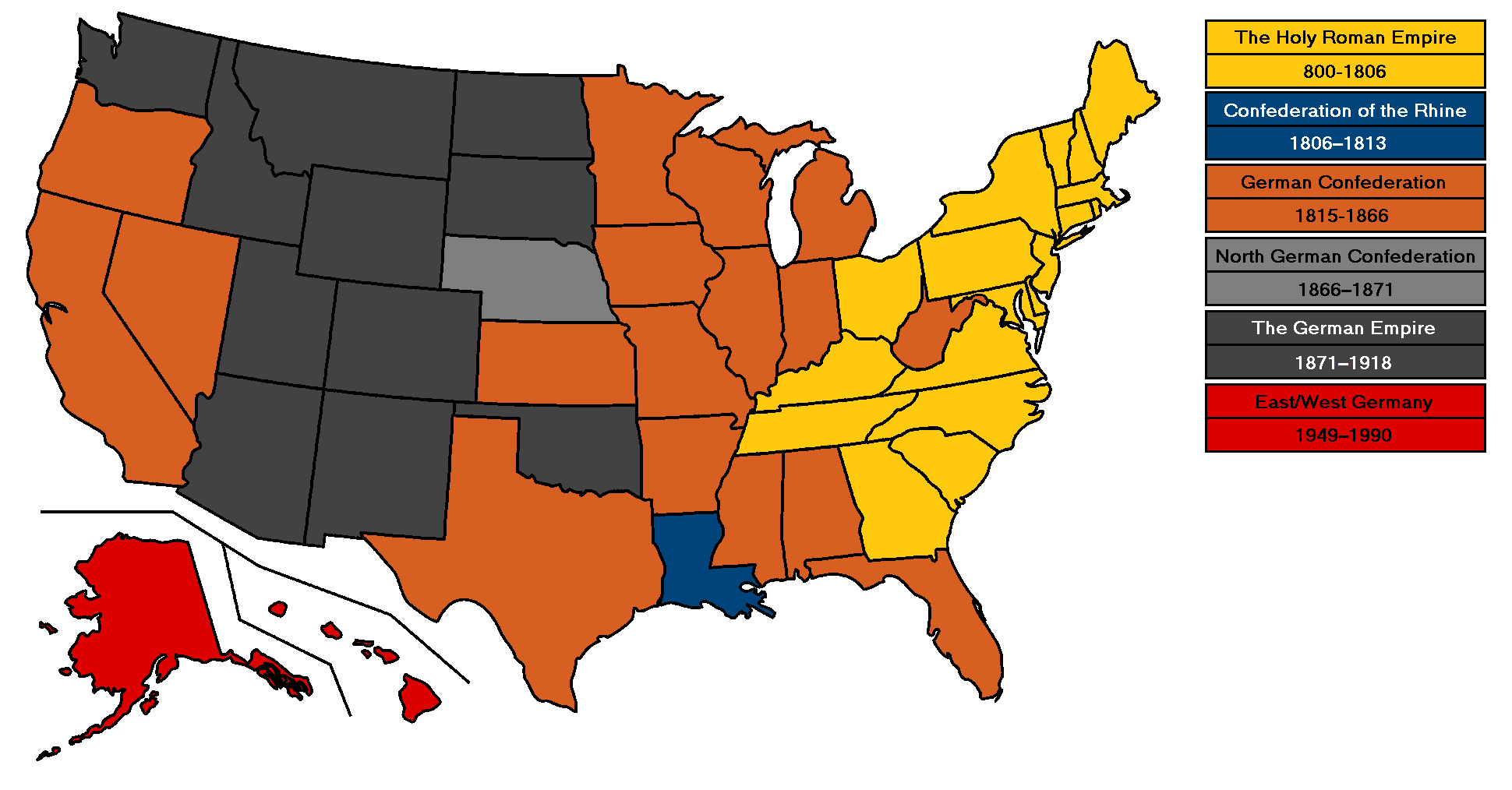
The Holy Roman Empire (800–1806)
- Connecticut
- Delaware
- Georgia
- Maryland
- Massachusetts
- New Hampshire
- New Jersey
- New York
- North Carolina
- Pennsylvania
- Rhode Island
- South Carolina
- Vermont
- Virginia
Confederation of the Rhine (1806–1813)
- Louisiana
German Confederation (1815–1866)
- Alabama
- Arkansas
- California
- Florida
- Illinois
- Indiana
- Iowa
- Kansas
- Kentucky
- Maine (note mistake on map)
- Michigan
- Minnesota
- Mississippi
- Missouri
- Nevada
- Ohio
- Oregon
- Tennessee
- Texas
- West Virginia
- Wisconsin
North German Confederation (1866–1871)
- Nebraska
German Empire (1871–1918)
- Arizona
- Colorado
- Idaho
- Montana
- New Mexico
- North Dakota
- Oklahoma
- South Dakota
- Utah
- Washington
- Wyoming
East/West Germany (1949–1990)
- Alaska
- Hawaii
and finally here’s a list of when each state joined the United States:
1787
- Delaware – December 7
- Pennsylvania – December 12
- New Jersey – December 18
1788
- Georgia – January 2
- Connecticut – January 9
- Massachusetts – February 6
- Maryland – April 28
- South Carolina – May 23
- New Hampshire – June 21
- Virginia – June 25
- New York – July 26
1789
- North Carolina – November 21
1790
- Rhode Island – May 29
1791
- Vermont – March 4
1792
- Kentucky – June 1
1796
- Tennessee – June 1
1803
- Ohio – March 1
1812
- Louisiana – April 30
1816
- Indiana – December 11
1817
- Mississippi – December 10
1818
- Illinois – December 3
1819
- Alabama – December 14
1820
- Maine – March 15
1821
- Missouri – August 10
1836
- Arkansas – June 15
1837
- Michigan – January 26
1845
- Florida – March 3
- Texas – December 29
1846
- Iowa – December 28
1848
- Wisconsin – May 29
1850
- California – September 9
1858
- Minnesota – May 11
1859
- Oregon – February 14
1861
- Kansas – January 29
1863
- West Virginia – June 20
1864
- Nevada – October 31
1867
- Nebraska – March 1
1876
- Colorado – August 1
1889
- North Dakota – November 2
- South Dakota – November 2
- Montana – November 8
- Washington – November 11
1890
- Idaho – July 3
- Wyoming – July 10
1896
- Utah – January 4
1907
- Oklahoma – November 16
1912
- New Mexico – January 6
- Arizona – February 14
1959
- Alaska – January 3
- Hawaii – August 21


Leave a Reply