Brilliant Maps

Making Sense Of The World, One Map At A Time

  • BOOK!
  • Newsletter
  • Board Games
  • Posters
  • Scratch Maps

What If Nazi Germany Won World War II? Fictional & Historical Scenarios

Last Updated: September 9, 2025 219 Comments

Click To Get My 10 Best Brilliant Maps For Free:


Europe under Nazi domination

How close Nazi Germany came to dominating Europe. Map by Morgan Hauser via Wikimedia
What if Hitler and the Nazis had won World War II? This is perhaps the greatest historical ‘what if’ of all time. The map above shows just how close they came.

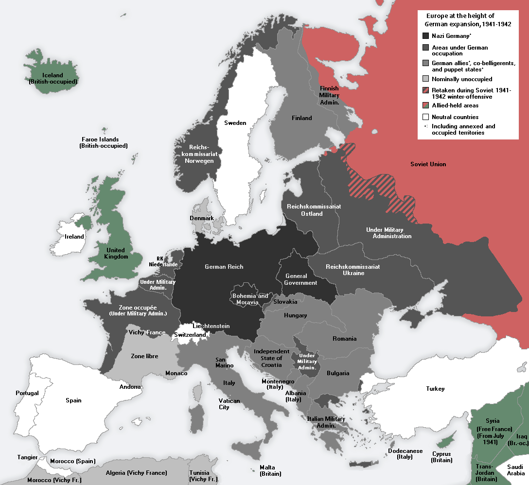
This has led both novelists and historians to speculate about might have happened if Germany had won the war and how they might have done so. Below we’ll look at a few fictional scenarios (with maps) where they do win and what that means for the rest of the world. This will be followed by some historical speculation about whether or not Germany really could have won.

[Read more…]

Filed Under: History Tagged With: books, fiction, war

The Obesity Epidemic in America Summed Up In One Map

Last Updated: March 3, 2023 2 Comments

Click To Get My 10 Best Brilliant Maps For Free:

Obesity epidemic in America

Map by Ricky Linn

Why is America so fat? Well as this faux Time magazine cover created by Ricky Linn shows, it may be because the country looks like a man gorging himself on an Alaskan-sized burger.

[Read more…]

Filed Under: United States Tagged With: humour

1919 Women’s Suffrage Victory Map, Published The Year Before The Passage Of The 19th Amendment

Last Updated: March 3, 2023 Leave a Comment

Click To Get My 10 Best Brilliant Maps For Free:

1919 Women's Suffrage Map

Map by National Woman Suffrage Publishing via Norman B. Leventhal Map Center at the Boston Public Library

As difficult as it may be to believe, the The Nineteenth Amendment to the United States Constitution was ratified on August 18th, 1920, less than 100 years ago. It stated that: “The right of citizens of the United States to vote shall not be denied or abridged by the United States or by any State on account of sex.” In plain English, it gave the vote to all women of voting age.

However, before its passage, not all women had been denied the vote as the map above demonstrates.
[Read more…]

Filed Under: United States Tagged With: voting, women

Byzantine Constantinople Before It Was Istanbul

Last Updated: March 3, 2023 2 Comments

Click To Get My 10 Best Brilliant Maps For Free:

Byzantine_Constantinople-en

Topographical map of Constantinople during the Byzantine period, by Cplakidas via Wikimedia

Constantinople has been the capital of 4 different empires during its long history. The Roman, Byzantine (or Eastern Roman), Latin and Ottoman empires all coveted the city due to its strategic and commercial importance.

[Read more…]

Filed Under: History Tagged With: Byzantine, Constantinople

Scotland’s Watershed Is So Wild That Only 6 People Have Managed To Complete The Whole Route

Last Updated: January 17, 2025 9 Comments

Click To Get My 10 Best Brilliant Maps For Free:

The route of Scotland's Watershed

The Scottish Watershed, map provided by Peter Wright
The Scottish Watershed separates the drainage and river systems that flow east into the North Sea from those that flow west into the Atlantic. The map above shows its route from the English Border to the North of Scotland at Duncansby Head (near the more famous John O’ Groats).

Or, as Peter Wright (one of the only people to have walked it) puts it:

[Read more…]

Filed Under: Scotland Tagged With: walking, watershed

Where Are All The Toilets On The London Underground? This Tube Map Has The Answer

Last Updated: June 25, 2025 Leave a Comment

Click To Get My 10 Best Brilliant Maps For Free:

Where Are All The Toilets On The London Underground? This Tube Map Has The Answer

Click on the map for a full size version, part of TFL’s Accessibility guides
Locating a working loo in London is not always easy, especially on the Tube.

The lack of toilets on the London Underground, is just one of many complaints Londoners have with the network that celebrated it’s sesquicentennial anniversary in 2013.

Looking at the tube map above it’s easy to see why. In zone 1 (central London), only Baker Street (men only), Shoreditch High Street and Hoxton have any toilet facilities within the gateline and none have baby changing facilitates. Only when you get outside of central London do you start finding stations that actually have toilets in them.

Full list:

[Read more…]

Filed Under: London Tagged With: toilet, tube

The 26 Largest Islands In The World Compared

Last Updated: May 19, 2026 43 Comments

Click To Get My 10 Best Brilliant Maps For Free:

relative size of the 24 largest islands in the world

The relative size of the 26 largest islands in the world, map by reddit user evening_raga

The map above shows the relative size of the world’s 26 largest islands. Combined they cover 7.7 million square km (roughly the size of Australia) and have 540 million people living on them (behind only China and India).

If you’re curious to learn a bit more about them, below you can find their names, what country (or countries) they belong to, their areas and the population of each island (data from Wikipedia):

[Read more…]

Filed Under: World Maps Tagged With: area, comparison, islands

What Country Is Across From You, If You’re On A Beach In Britain or Ireland

Last Updated: March 3, 2023 2 Comments

Click To Get My 10 Best Brilliant Maps For Free:

Across the shores from Britain

Map by reddit user TheWinterKing

Inspired by the popular map of Which Countries Are Due East And West Of The Americas, this version looks at the same for British Isles (UK + Ireland), with North and South added in too.

[Read more…]

Filed Under: Europe Tagged With: directions, interesting

California, Sweden and Madagascar Are Surprisingly Similar in Size

Last Updated: June 9, 2025 3 Comments

Click To Get My 10 Best Brilliant Maps For Free:

California vs Madagascar

California vs Madagascar, by Reddit user Mattho via mapfrappe.com
Did you know that California, Sweden and Madagascar are all quite similar in size?

Don’t believe me? Well look at the map above comparing California and Madagascar or the one below comparing Sweden and Madagascar. Here are a few comparisons between the 3 based on data from Wikipedia:

In terms of total area:

[Read more…]

Filed Under: Other Tagged With: area, comparison, population

Why The United States Is A ‘-Stan’ Country Like Kyrgyzstan

Last Updated: March 3, 2023 7 Comments

Click To Get My 10 Best Brilliant Maps For Free:

Map places ending in -stan aka Stanistan

Why are there so many countries that end in -stan? In total 7 countries: Afghanistan, Kazakhstan, Kyrgyzstan, Pakistan, Tajikistan, Turkmenistan and Uzbekistan include the suffix -stan in their names.

These countries have a combined population of nearly 280 million people (fewer than only China, India and the United States) and cover an area of 5.45 million square kilometers (7th largest in the world).

[Read more…]

Filed Under: Video Tagged With: -stan, names

  • « Previous Page
  • 1
  • …
  • 151
  • 152
  • 153
  • 154
  • 155
  • Next Page »


Product Reviews · World Atlas · Settlers of Catan · Risk · Game of Thrones · Coloring Books
Globes · Monopoly · Star Wars · Game of Life · Pandemic · Ticket To Ride · Drinks Cabinets
US Locations · UK Locations· Fleet Management
Copyright © 2026 · Privacy Policy · Fair Use, Attribution & Copyright · Contact Us
Follow Us: Newsletter · Facebook · Youtube · Twitter · Threads · BlueSky · LinkedIn · Instagram · Pinterest · Flipboard