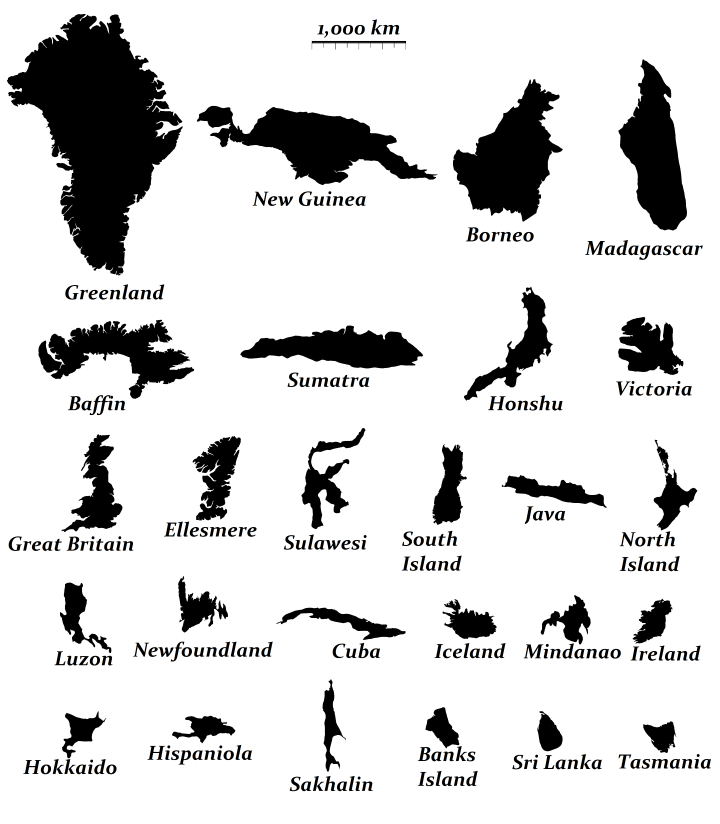
If you’re curious to learn a bit more about them, below you can find their names, what country (or countries) they belong to, their areas and the population of each island (data from Wikipedia):
- Greenland (autonomous country within the Kingdom of Denmark); area: 2,130,800 km2; population: 56,344
- New Guinea (Indonesia and Papua New Guinea); area: 785,753 km2; population: 11,306,940
- Borneo (Brunei, Indonesia, and Malaysia); area: 748,168 km2; population: 19,804,064
- Madagascar (Madagascar); area: 587,713 km2; population: 22,005,222
- Baffin Island (Canada); area: 507,451 km2; population: 10,745
- Sumatra (Indonesia); area: 480,848 km2; population: 50,365,538
- Honshu (Japan); area: 225,800 km2; population: 103,000,000
- Victoria Island (Canada); area: 217,291 km2; population: 1,875
- Great Britain (United Kingdom); area: 209,331 km2; population: 60,800,000
- Ellesmere Island (Canada); area: 196,236 km2; population: 146
- Sulawesi (Indonesia); area: 180,681 km2; population: 18,455,058
- South Island (New Zealand); area: 145,836 km2; population: 1,058,500
- Java (Indonesia); area: 138,794 km2; population: 143,000,000
- North Island (New Zealand); area: 111,583 km2; population: 3,450,800
- Luzon (Philippines) area: 109,965 km2; population: 48,520,774
- Newfoundland (Canada); area: 108,860 km2; population: 479,105
- Cuba (Cuba); area: 104,556 km2; population: 11,167,325
- Iceland (Iceland); area: 101,826 km2; population: 316,252
- Mindanao (Philippines); area: 97,530 km2; population: 25,281,545
- Ireland (Republic of Ireland and United Kingdom); area: 84,421 km2; population: 6,378,000
- Hokkaido (Japan); area: 78,719 km2; population: 5,507,456
- Hispaniola (Dominican Republic and Haiti) area: 76,480 km2; population: 19,442,012
- Sakhalin (Russia) area: 72,493 km2; population: 580,000
- Banks Island (Canada) area: 70,028 km2; population: 136
- Sri Lanka (Sri Lanka)area: 65,268 km2; population: 20,277,597
- Tasmania (Australia) area: 64,519 km2; population: 514,700
This is what the world would look like if it were only made of islands:
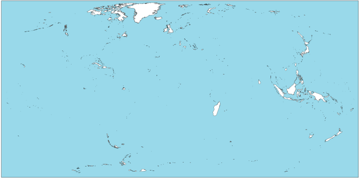
- Canada fully owns 5 of the top 26 islands, while Indonesia owns all or part of 5 as well.
- The most populated island is Indonesia’s Java with 143 million people.
- The least populated is Canada’s Banks Island with just 136.
- The United States does not have a single island in the top 26, with the largest being Hawai’i (Big Island), which is only the 76th largest in the world.
- Only 4 islands belong to more than one country – New Guinea, Borneo, Ireland and Hispaniola
Why isn’t Australia considered an island?

In fact, if it was an island it would be roughly as large as the next 26 combined.
Most Populous Islands
This map from Nazzar Data shows the World’s most populous islands:
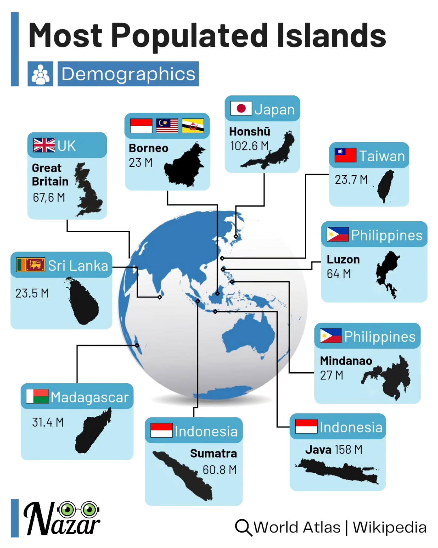
They are:
- Java: 158 million
- Honshu 102.6 million
- Great Britain 67.6 million
- Luzon 64 million
- Sumatra 60.8 million
- Madagascar: 31.4 million
- Mindanao: 27 million
- Taiwan 23.7 million
- Sri Lanka: 23.5 million
- Borneo: 23 million
5 Islands With GDPs of Over $1 Trillion
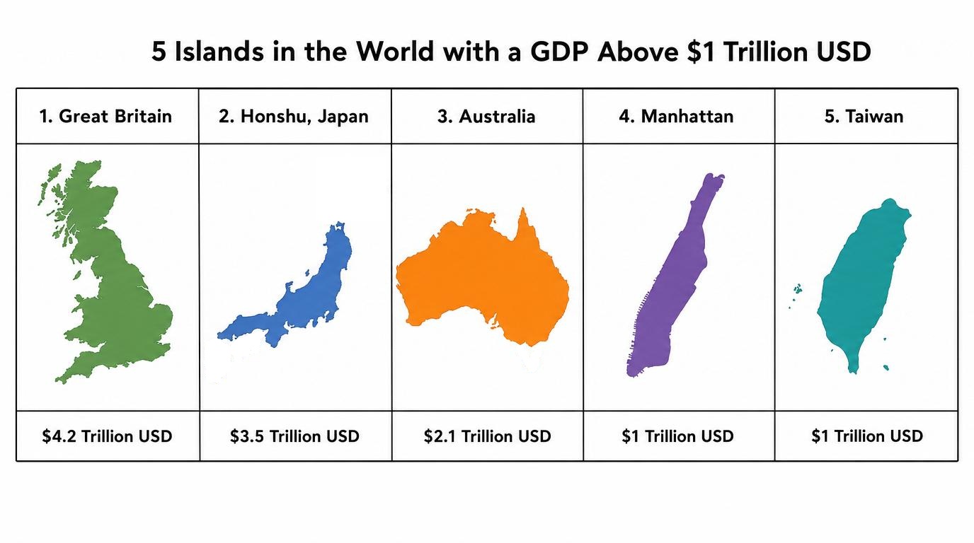
And finally only 5 islands in the world have a Nominal GDP of over $1 Trillion USD as of early 2026 (and that’s if we include Australia). They are:
- Great Britain, UK: $4.2 Trillion
- Honshu, Japan: $3.5 Trillion
- Australia $2.1 Trillion
- Manhattan, NY $1 Trillion
- Taiwan $1 Trillion
Want to learn more about the world’s islands? Then have a look at:
- Atlas of Remote Islands
- The World Island: Eurasian Geopolitics and the Fate of the West
- Once Upon An Island: An Atlas of Islands from around the World
Have any feelings about islands? Have your say below:


Brilliant Maps says
I’ve looked into a bit more and the original map creator defined islands as anything that weren’t continents, so they’ve excluded Australia (island) because it’s the largest land mass in Australia (continent).
I think this makes a certain amount of sense as it would make comparisons difficult, due to the scale you’d have to use (Australia being 3X the size of Greenland).
Anthony Daly says
Without being pedantic one definition of island is:
a piece of land surrounded by water:
Mainland Australia IS an island per the definition of island. Stop playing around with words to suit your own agenda.
Keivan Hadji Hossein says
Think about Africa and Antarctica: their main landmasses measure respectively 29.7 million km2 (Madagascar excluded) and 14 million km2. They’re detached from other continents and they do have a large number of islands that are still considered part of their continents. Nevertheless, their landmasses are never considered to be “islands” on their own. Same goes for Australia (excluding Tasmania): it actually is Oceania’s main landmass rather than a simple island.
Ken says
Africa is not “detached from other continents”. It simply became physically discontiguous with Eurasia when a canal was dug a few generations ago.
Juan Pérez says
Only 4 islands belong to more than one country – New Guinea, Borneo, Ireland and Hispaniola**** There are at least 5 considering Tierra del Fuego Island.
Answerer says
Actually there are seven significant islands with borders: the five you mentioned, plus Timor (whose estarn part gained independence from Indonesia) and Cyprus (whose nothen third was invaded by turkish scum). Other divided islands are smaller at least fifteen times Cyprus and scarcely inhabited, so their relevance is much less.
Dion says
I feel like we have to say something about Saint Martin/Sint Maarten. It’s little, but seems significant.
Dan says
Don’t forget Great Britain—home to England, Scotland and Wales
NEU Engineering CC says
If Australia isn’t an Island then how come Christine Anu sings about “My Island Home?”
drooghead says
She grew up in Cairns and the Torres Strait islands so the island she is referring to is not the Australian mainland but the Torres Strait islands.
Jo says
I disagree, it is because most Australians regard the country as an island. Cairns is on the mainland…. proof, her lyrics say “My home is Australia. We are a land bound by sea. Though I may travel far across the ocean, it will never forget me…. My island home, my island home, my island home is waiting for me”.
Jenanne says
Besides, “my continent home” sung 3 times in a row, would upset the rhythm of the song!
mP says
She could be singing about the many islands off the Queensland coast.
Arphaxad says
She also could just be straight up mistaken about it. Just because some random singer says something is true doesn’t make it true. Do you believe women are pieces of heavy machinery simply because Miley Cyrus came in like a wrecking ball?
JJ says
miley cyrus is more famous, does she sing about islands? but i wonder also about Celine Dion- she is Canadian and they have a number of islands, mayve someone should ask her? Are there any famous people from Hawaii- they have a lot of islands too- singers im not so sure about. Although when a person arrives on an island it is customary to get lei’d by the locals, they normally sing while doing that. Let’s all go to Hawaii on a fact finding mission.
Karlis says
Christine Anu didn’t write it, she just covered it. Warumpi Band wrote it, an indigenous band from the Northern Territory, so you’re all wrong.
Anthony Daly says
Arphaxad you should look at your own comments. Just because someone said that continents don’t qualify as islands that it is true. That statement alone is not true per the definition of an island, look up the definition before either believing or listening to someone else’s opinion.
NEU Engineering CC says
New Zealand’s South Island is (mostly) on the Pacific plate. It is the largest land mass on that plate, is it an contitnent too?
Sawdust says
Actually, there is some talk recently about exactly this point…that New Zealand could be considered a (small) continent!
Des says
New Zealand has recently been recognised to be the largest islands of a newly defined continental plate.
https://en.m.wikipedia.org/wiki/Zealandia
Aussieeee says
Australia is a country not a continent…
i usually call the continent oceania
sooooo whadda bout now?
Karlis says
You’re simply wrong and don’t have a clue about Australia. Oceania is a geographical region that covers islands not even on the same continent.
R. Snider says
On the topic of islands owned by two countries, I believe you forgot Sint Maarten/St. Martin owned by the Netherlands and France.
Ken says
There a five bullet point below the heading listing “a few more facts about the islands above”. Those islands above are the 26 largest islands, so Märket and Saint Martin are not included, as they are too small.
Rick Tavares says
Also St Martin
Drake says
Why do some publications flip Victoria Island and Great Britain on these lists? They are fairly close in area, but there seems to be some disagreement about which one should be first.
Jeff says
It depends whether the tide is in or out 😉
Shuhananabinkinsha says
I know right!!!!!!!!!!!!!!!!!!!!!!!!!!!!!!!!
Shubananadinkinsha says
The map was very cool, but you did not answer my question of where Wales ranks on the scale of islands.
Emma says
There is no Victoria Island. It is Vancouver Island.
Brilliant Maps says
https://en.wikipedia.org/wiki/Victoria_Island_(Canada)
TR says
Victoria Island is in NWT and is far larger than Vancouver Island.
Wayne Dobson says
Victoria is in the Arctic They missed Vancouver completely!
Dan says
Vancouver Island is about half the size of Tasmania, the smallest island on this list.
Larry Vandiver says
As a third grader in 1952, we were taught that Australia was the Island Continent. Yes, I’m old, but I do remember Mrs. Myer, my third grade teacher telling us that. It was also referred to as the Land Down Under.
Sarah says
You are correct Larry
Chuck says
Pluto is also the ninth planet. My teachers in the 1970s told me so.
YourGrace3219 says
You are right! Pluto has always been my favorite planet! I was shocked and dismayed when it was reclassified as a dwarf planet! I’m still pissed.
e says
What about Newfoundland, Canada. The island part is 108,890 kms sq. Population 525,073 in 2018.
Fab4ever says
Didn’t anyone have some inspiration to name the New Zealand islands? North Island and South Island… Boring. While the whole country is so beautiful and diverse in landscapes, nature, views, etc.
Smithy says
How is Australia not an island!! It’s a land mass completely surrounded by ocean/sea. Which is what the simple definition of an island actually is.
peter piper says
Yes it is.. did you not learn about the formation of the the world in geographical formation?
Karlis says
Australia is an island. Always has been. Always will be. Oceania is not a continent, it is a geographical region that includes islands that are not even on the same continent as the others, eg. New Zealand. Our indigenous population call it an island, you foreigners don’t get an opinion.