Or, as Peter Wright (one of the only people to have walked it) puts it:
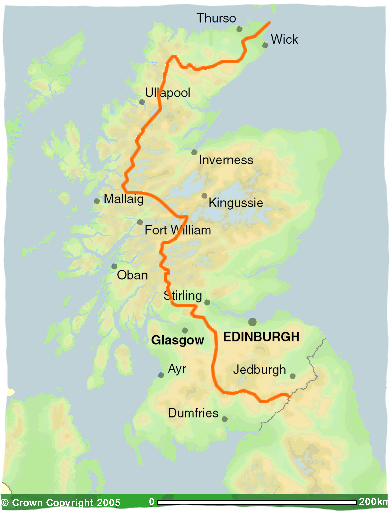
Now imagine that you are a raindrop about to land on Scotland. Where you finally end up, will follow very simply, from where you touch down in the landscape – for by bog, burn and river you will make a watery journey to either the Atlantic Ocean or the North Sea. There is a clear line, a demarcation that has now been drawn on the map, which is the simple divide between which of these you are bound for- that line is the Watershed of Scotland.
He’s gone on to dub the Watershed a Ribbon of Wildness and the ‘backbone of Scotland.’
Now, if you look closely at the map above, you may notice that the Watershed avoids virtually all of Scotland’s major population centres. For those of you visiting from outside the UK (or from South of the Border), Scotland covers roughly 1/3rd of the land area of the island of Great Britain, but has less than 10% of the population.
This makes Scotland far more wild than either England or Wales. Combine this wildness with the fact that the Watershed is over 1,100km (680 miles) long and has an average elevation of 450m (1,476ft) over 44 Munros and you begin to see why so few people have completed the route.
In total, Wikipedia lists 6 people who’ve completed some version of the route. The main debate surrounds where the Watershed ends, either Cape Wrath or Duncansby Head.
Dave Hewitt was the first to complete the Cape Wrath route in 1987, and Peter Wright was the first to complete the Duncansby Head route in 2005. Colin Meek become the first person to run the whole route in 2012, opting for the Duncansby Head option.
You can learn more about the Watershed from the following sources:
- Peter Wright’s websites: The Watershed Epic and the more recent Ribbon of Wildness, plus follow him on Twitter and Facebook.
- Peter Wright’s 3 books about the Watershed: Ribbon of Wildness: Discovering the Watershed of Scotland, Walking with Wildness: Experiencing the Watershed of Scotland & Nature’s Peace: A Celebration of Scotland’s Watershed
- Dave Hewitt’s book Walking the Watershed
Update 14/01/15: Seems we can add Chris Townsend as a 7th person to have completed the trek.
Would you like to walk Scotland’s Watershed? Why or why not? Leave a comment below:


Sheumais says
I’m far too lazy and I don’t like camping or midges, other than that, it sounds great.
Howard Kellett says
Is there a path ?
Kamil says
I have begun but it will be walked in a number of small stages as I have two children and a job with a holiday allowance that doesn’t just allow to disappear for 60 days on Munros.
Nonetheless, here’s the trailer for the first 2 days. More later in the year!
https://youtu.be/m7NfXQsHa8w
Frank says
No path. Some parts almost impenetrable. Chris Townsend admits he often strayed away from the true watershed.
Jo Walton says
Peter Wright, now aged 74, is cycling the watershed route this summer, 2021 (as closely as possible) for Edinburgh charity, The Green Team, to support young carer’s to get time out in nature. https://www.greenteam.org.uk/petes-pedal-for-young-carers/
David Findlay says
Surely you mean the first person to publicly complete the route or the only 6 people to publicise that they completed the route. What ridiculous assumptions to say only if the author if this article has heard of it did it happen.
Brilliant Maps says
It’s extremely difficult to do, so I highly doubt someone just randomly walked it earlier.
Tom says
I love the romance of doing it, but maybe not the actuality, still I can dream and when I’m there I’ll give you a wave of hello in passing.
Rachel Clarke says
Hello! This is epic! Is there a GPX of the route I can download, or a detailed map I could use to plot my own please?
I walked the CWT and hated it. So clearly now I feel the need to do this…