
Here’s some stats on how they compared:
| Roman Empire | Italian Empire | |
|---|---|---|
| Peak Size | 5.0 million km2 (1.93 million sq miles) | 3.825 million km2 (1.48 million sq miles) |
| % of World | 3.71% | 2.84% |
| Peak Year | 117 | 1941 |
| When Did It Start? | 27 BC | 1882 |
| When Did It End? | 395 AD or 476 AD or 1453 AD | 1947 or 1960 |
| How Many Years Did It Last? | It's complicated, but between 422 and 1,480 years | 78 years using the most generous timescale |
| How Many People Did It Have? | 46 - 75 million | Around 58 million |
| % of World Population | up to 30% | Around 2.5% |
* A note on population figures there is a lot of dispute around Rome’s population figures, which you can read about here. Similarly there is no one figure for the Italian Empire I could find online, but ChatGPT gave the estimate based on the population on each of the parts of the Empire.
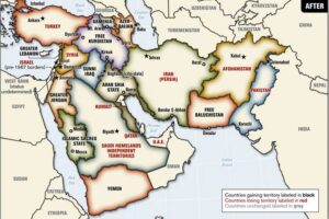
Territories held by both the Roman and the Italian empires
- Central & western Mediterranean
- Italian peninsula (obviously Rome itself)
- Sicily, Sardinia, Corsica
- Adriatic coast: Istria and much of Dalmatia
- Albania, most of mainland Greece, Crete
- North-African littoral
- Narrow coastal belt of today’s Tunisia
- Northern Libya: Tripolitania & Cyrenaica
- How / when
- Roman rule: provinces secured between the 2nd c. BCE and 1st c. CE, held for centuries.
- Italian rule:
- Libya annexed 1911 → unified colony 1934
- Dodecanese & other Aegean islands seized 1912, ceded 1923
- Albania became an Italian protectorate/“personal union” 1939
- Dalmatia, most of Greece, and coastal Tunisia were wartime occupations only (1941-43), never fully annexed.
Territories held only by the Roman Empire
- Iberian Peninsula
- Gaul (modern France), Britain, Belgium–Netherlands–western Germany
- Alpine zone: Switzerland, much of Austria
- Interior Balkans: Bosnia to Romania and the Danube frontier
- Asia Minor (Turkey) and the entire Levant
- Egypt, the Red-Sea littoral, parts of the Sahara fringe
- Mesopotamia, Armenia
- How / when: Conquered piecemeal from 2nd c. BCE to 2nd c. CE; never claimed by modern Italy.
Territories held only by the Italian Empire
- Libyan interior (Fezzan)
- Horn of Africa
- Off-map: Tientsin (Tianjin) concession in northern China (leased 1901-43)
- How / when: Acquired during the late-19th-century “Scramble for Africa” and Fascist expansion of the 1930s; never part of the ancient Roman sphere.
Big picture: only limited Mediterranean coastal strips overlapped; Rome’s empire sprawled far wider into Europe and the Near East, while modern Italy’s unique possessions lay mainly in Africa (plus one tiny Chinese enclave).
More Roman Empire Maps:
- The Roman Empire Shown Over Modern Day European Countries
- How Long Each Territory Was Part of The Roman Empire (Western and/or Eastern)
- Estimated Population Distribution of The Roman Empire in 165 AD
- Map Of The Roads Of The Roman Empire in 200AD
- Size Of The Roman Empire At Its Height Vs The United States
- Current Religions Of The Roman Empire
- An Incredibly Detailed Map of the Roman Empire At Its Height in 211AD
- Roman Empire GDP Per Capita Map Shows That Romans Were Poorer Than Any Country Today
- The Roman Empire vs. The Mongol Empire At Their Respective Peaks


Ulf Tennfors says
Why do you say the Italian Empire ended 1947 or 1960? Shouldn’t it end when Italy lost WW2? Did Italy had any colonies left after the war?
Brilliant Maps says
Treaty of Paris signed in 1947, which was the formal end to their Empire. However, Italy ran the Trust Territory of Somaliland from 1950 until 1960.