
There lots of really cool things to point out about the map itself. For example:
- You can see the Hadrian’s Wall and the less famous but more northern Antonine Wall.
- There are 870 Roman cities and settlements within the Roman Empire and more than 90 cities and settlements outside of the Empire.
- The headquarters of all 33 active legions.
- 120,00 km of Roman Roads.
- Caravan, trade and sea routes
You can buy a copy here.
Why 211 CE? The reason 211 CE was picked was that this was roughly the height of the Roman Empire.
The 4 Emperors that followed Septimius Severus were each assassinated, ultimately culminating in the Crisis of the Third Century, which almost resulted in the Empire’s total collapse.
Here are a few close-ups of sections of the maps:
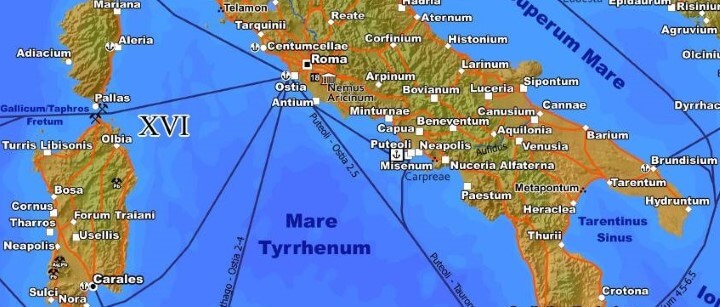
The area around Rome (Roma) in Italy.
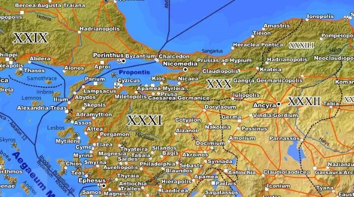
Notice the Roman city of Byzantium. In 330 AD it was renamed Constantinople and became the capital of the Roman Empire. Today it’s known as Istanbul, the largest city in Turkey.
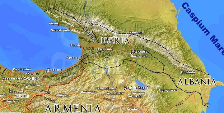
Map of the Caucasus. Notice the Kingdom of Iberia and Caucasian Albania neither of which are where you’d expect them to be.
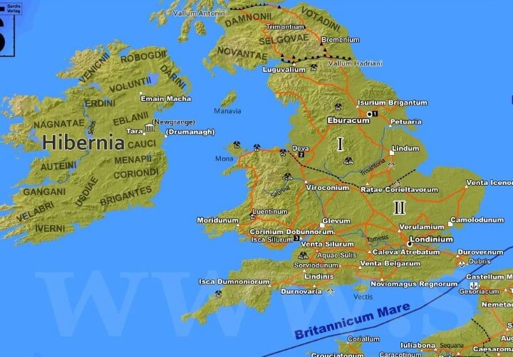
Britain and Ireland (Britannia & Hibernia) in 211 CE. While Britannia was part of the Roman Empire, Caledonia to the north (modern Scotland) and Hibernia (modern Ireland) were not. Septimius Severus died in Eboracum, modern day York.
To learn more about the Roman Empire have a look at:
- Barrington Atlas of the Greek and Roman World
- Ancient Rome: The Rise and Fall of An Empire
- The Decline and Fall of the Roman Empire, vol. 1-6
Also see:
- Map Of The Roads Of The Roman Empire in 200AD
- Roman Empire GDP Per Capita Map Shows That Romans Were Poorer Than Any Country Today
Enjoy these maps? Then please share this post with a friend:


KORONEL says
I think there is a mistake. Near Gades (named Cadiz today at southern Spain) is the city of Hasta. This city is an italian city, not spanish. Sorry if I’m wrong.
Anthony Lappin says
‘Hasta’ means spear in Latin, so was probably quite common as a place name in ancient times.
KORONEL says
You are right. I was born near Gades (named Cadiz today) in the city of Jerez de la Fontera. “Hasta” could be “Asta Regia”, but this city. I think, was destroyed before Roma come to this zone, and is an ancient tartessian city. Maybe its all ok. Thanks.
vfhbekj says
I was born in DCCLXXX C.E in the byzantine empire
Uxi says
Pretty cool. Nitpick, but the A.D. goes before the year, not after. “Anno Domini” or “in the year of Our Lord, 211” etc. Pet peeve.
Eric says
A.D. does not go before the year. 211 A.D. is 211 years after the year of our Lord.
Paul de Haan says
Uxi is correct. AD precedes the date, BC follows it. CE & BCE both follow it.
Anton Sherwood says
Which part of “A.D.” means ‘after’?
Rebecca says
No part. AD stands for Anno Domini which means “in the year of (our) Lord”, shortened from Anno Domini Nostri Iesu Christi “in the year of our Lord Jesus Christ. It goes before the date to be read alternately, AD 211 or In the year of our Lord 211, counting from the presumed date of the birth of Jesus. BC stands for the English, Before Christ, and was somehow translated and adapted from the Latin a.Ch.n. or ACN, Ante Christum Natum or Before the birth of Christ. Although the notations used have changed to B.C.E (Before the Common Era)and C.E.([of the]Common Era) , the eras represented remain the same.
Fred Z in Ann Arbor says
Labeling leaves a lot to be desired.
kingflathead says
It would be a nice touch if we could get one with the legend in Latin only. Also, it seems that you are using the dating system of some kind of cult. Anno Urbis, please.
PS, what is a km? Is it like a mille?
Anthony Lappin says
Lol… Chiliometrum
horsedancingwithcrow says
oH… i Love history! Arpinum near rome. where my blood is from !
jbird669 says
What the hell is CE?
Anthony Lappin says
‘CE’ as an abbreviation of ‘Christian Era’ has been used since 1652, as
‘Common Era’ since 1708 and as ‘Current Era’ since 1856. The terms are
interchangeable and are preferred (as opposed to AD – Anno Domini) since
the advent of mass, global communication. because it can be used
unambiguously with audiences of non-christian backgrounds.
jbird669 says
Makes sense, but I don’t prefer it.
Stephen Rose says
Logically, A.D., otherwise known as Anno Domini, or “year of Our Lord” only really applies to Christians. C.E. and B.C.E. are relatively neutral terms that can be used by anyone, of any faith without the presumption that they accept the Christian faith by labelling their dates with the concept of “since our Lord and Saviour was born”.
Not that the epoch date seems to be accurate for that though, since Herod died in 4 BCE…
jbird669 says
1) since when do humans act logically?
2) I hear you.
Emm deWorde says
Well, lots of us do.
jbird669 says
Well, you go girl.
Emily Hail Truitt says
I love this poster, but when the shipping costs are more than the cost of the map itself, I have trouble justifying the expense.
Graham Asher says
It looks a lot of fun, but it could be so much better. The projection is terrible – probably plate carrée. Some names are misspelt (Caleva Atrebatum should be Calleva…). Some provinces, like Africa Proconsularis, are densely packed with place names, which is great, but others, like Britannia, are rather sparsely mapped, omitting many known names that would fit easily on the map. Tribal names are given only outside the empire, but in fact many areas retained their tribal identity; for example, the Brigantes are named in SE Hibernia, but not in NE Britain, where they also lived, except for the clue in the name Isurium Brigantum. River names are straight; they should curve along the river. With more careful design, a lot more information could be given without cluttering the map, such as road names and province names rather than numbers referencing a key.
TRS says
Shouldn’t Internum Mare be Mare Nostrum? The Romans considered the Mediterranean their own sea.
david says
Excellent map! Greetings from Hispania!
Cunctator says
The map has seen some significant improvements over the last few years and also found a new home in the web:
https://www.tabulae-geographicae.de/english/imperium-romanum-211-ad/preview/
Ian McPherson says
Thanks form this fascinating map and smaller sections. No one else seems to have spotted the mistake in spelling the name of Roman York. In the section for Britain, the map appears to give the name as Eburacum, with an ‘u’ in place of ‘o’. I have always believed that the Roman name is Eboracum, as is stated in the commentary on the map. The name ‘Ebor’ is of course still used, as in the name of a well-known horse race at York.
Ian
Jonathan says
Link to website is broken
Aldon Brewer says
The creator of this map has moved to:
https://www.tabulae-geographicae.de/
Just in case anyone is interested in purchasing these amazing prints!
Blenderyuz says
Europe, and in Ancient Russia