Brilliant Maps

Making Sense Of The World, One Map At A Time

  • BOOK!
  • Newsletter
  • Board Games
  • Posters
  • Scratch Maps

Olympus Mons (Mars) Largest Volcano In The Solar System Compared to France

Last Updated: March 3, 2023 6 Comments

Click To Get My 10 Best Brilliant Maps For Free:

Olympus Mons On Mars Compared to France

Created by amapaday

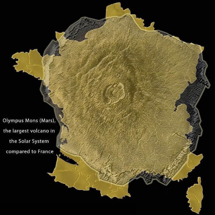
Olympus Mons is the tallest mountain and largest volcano on any planet in the solar system.

Its height from base to peak is 21.9 km (13.6 mi or 72,000 ft) or 26 km (16.2 miles) above the northern plains. This makes it at least two and a half times taller than Mount Everest’s height above sea level.

[Read more…]

Filed Under: Space Tagged With: comparison

Land Reclamation in the Netherlands 1300 Vs 2000: Before & After The Dikes

Last Updated: January 17, 2025 9 Comments

Click To Get My 10 Best Brilliant Maps For Free:

Land Reclamation in the Netherlands 1300 Vs 2000

Map created by reddit user Theman77777
The map comparison above shows what the land area of what makes up the Netherlands today, looked like in 1300 compared to what it looked like in 2000.

Around 17% of the country’s current land area has been reclaimed from the sea or lakes.

You can see a gif of this process below:

[Read more…]

Filed Under: History Tagged With: Netherlands

US State Highway Route Marker Shields

Last Updated: March 3, 2023 8 Comments

Click To Get My 10 Best Brilliant Maps For Free:

US State Highway Route Marker Shields

Map found via reddit

The map above shows the different highway route marker shield designs used by each US state for their own state highways.

While Interstate and US Numbered Highways use standard designs across the country, but the same can not be said of state highway markers.

[Read more…]

Filed Under: United States

Interactive Pangaea Map With Modern International Borders

Last Updated: April 21, 2023 35 Comments

Click To Get My 10 Best Brilliant Maps For Free:

Interactive Pangaea Map With Modern International Borders

Screenshot, see full interactive version below

One of our most popular maps is Pangaea With Current International Borders.

However, while it’s without a doubt an amazing map, many users have commented that they wished that you could see the whole world.

Fortunately, Massimo Pietrobon via Tomas Slavkovsky from Melown, has done just that, creating a fully interactive Pangaea map with modern international borders that allows you to explore the whole earth.

You can have a play around with it below:

[Read more…]

Filed Under: World Maps

If European Borders Were Drawn By DNA Instead Of Ethnicity

Last Updated: March 3, 2023 74 Comments

Click To Get My 10 Best Brilliant Maps For Free:

If European Borders Were Drawn By DNA Instead Of Ethnicity

Map originally found on reddit

The map above shows what the borders of Europe, the Middle East and North Africa might look like if they were based on the dominant Y-DNA haplogroup rather than ethnicity and/or any other political considerations.

[Read more…]

Filed Under: Border, Europe

Flat Earth “Globe”

Last Updated: March 3, 2023 3 Comments

Click To Get My 10 Best Brilliant Maps For Free:

Flat Earth

Map created by John Krygier at Making Maps

The map above shows what a “Globe” of the Earth would look like if the Earth was flat.

Most people accept that maps use a variety of projection techniques to render the 3D Earth onto a 2D plane. And that globes show us what the Earth really looks like.

However, flat Earth societies don’t buy this whole 3D/2D divide and believe (seriously or not) that the Earth is flat.

[Read more…]

Filed Under: Other Tagged With: globe

Luxembourg Is Not A Microstate!

Last Updated: March 3, 2023 7 Comments

Click To Get My 10 Best Brilliant Maps For Free:

Luxembourg Is Not A Microstate!

Map created by reddit user issoweilsosoll

The map above shows how big Luxembourg is compared to Singapore, Andorra, Malta, Liechtenstein, San Marino, Monaco, and the Vatican.

[Read more…]

Filed Under: Europe Tagged With: comparison

Map Showing How Airlines Divert Flights Around Syrian Airspace

Last Updated: March 3, 2023 1 Comment

Click To Get My 10 Best Brilliant Maps For Free:

flights avoid Syria

Map from flightradar24

The interactive map from flightradar24 above shows live flight locations for commercial civilian aircraft around the world.

When you zoom in on Syria you can see how airlines choose route their planes to avoid all Syrian and most Iraqi airspace.

[Read more…]

Filed Under: Other Tagged With: flights

Map of Europe, 1500 AD

Last Updated: March 3, 2023 10 Comments

Click To Get My 10 Best Brilliant Maps For Free:

Map of Europe, 1500 AD

Map created by reddit user Yetkinler

The map above shows the patchwork of kingdoms, principalities, bishoprics, duchies, republics, cities, sultanates, etc. in and around Europe in 1500 CE/AD.

[Read more…]

Filed Under: Europe, History

The Border Between Belgium & The Netherlands at Baarle-Hertog/Baarle-Nassau

Last Updated: March 3, 2023 3 Comments

Click To Get My 10 Best Brilliant Maps For Free:

The Border Between Belgium & The Netherlands at Baarle-Hertog/Baarle-Nassau

The map above shows the incredibly strange and complex border between Belgium and the Netherlands at Baarle-Hertog (Belgium) / Baarle-Nassau (Netherlands).

[Read more…]

Filed Under: Border, Europe Tagged With: Belgium, Netherlands

  • « Previous Page
  • 1
  • …
  • 123
  • 124
  • 125
  • 126
  • 127
  • …
  • 152
  • Next Page »


Product Reviews · World Atlas · Settlers of Catan · Risk · Game of Thrones · Coloring Books
Globes · Monopoly · Star Wars · Game of Life · Pandemic · Ticket To Ride · Drinks Cabinets
US Locations · UK Locations· Fleet Management
Copyright © 2026 · Privacy Policy · Fair Use, Attribution & Copyright · Contact Us
Follow Us: Newsletter · Facebook · Youtube · Twitter · Threads · BlueSky · LinkedIn · Instagram · Pinterest · Flipboard