Brilliant Maps

Making Sense Of The World, One Map At A Time

  • BOOK!
  • Newsletter
  • Board Games
  • Posters
  • Scratch Maps

Where Are All The Toilets On The London Underground? This Tube Map Has The Answer

Last Updated: June 25, 2025 Leave a Comment

Click To Get My 10 Best Brilliant Maps For Free:

Where Are All The Toilets On The London Underground? This Tube Map Has The Answer

Click on the map for a full size version, part of TFL’s Accessibility guides
Locating a working loo in London is not always easy, especially on the Tube.

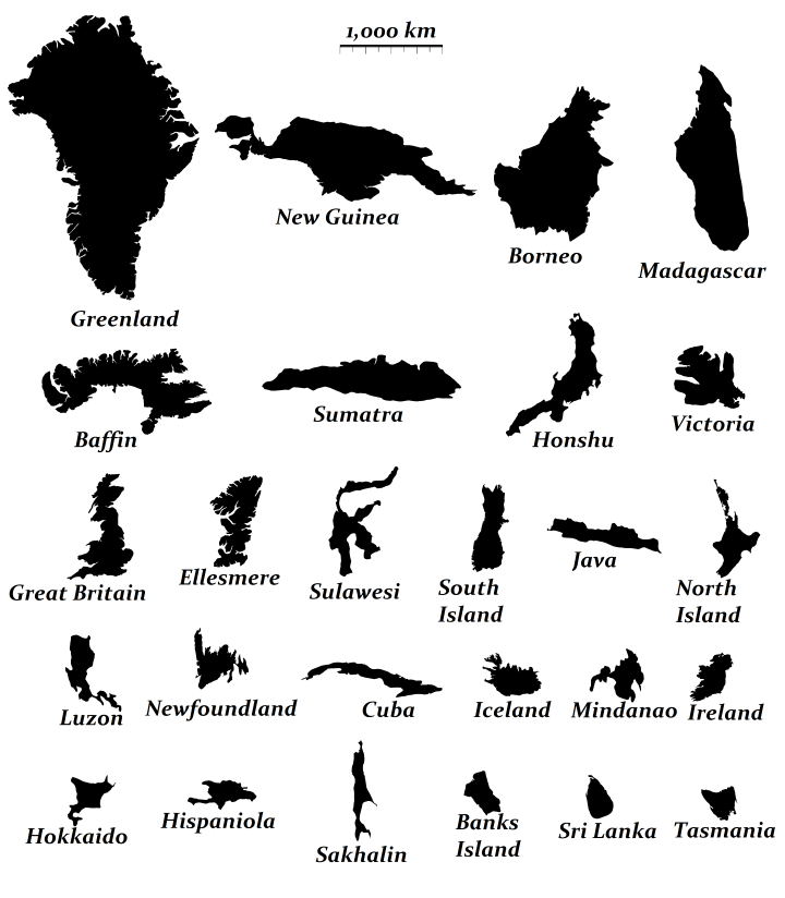
The lack of toilets on the London Underground, is just one of many complaints Londoners have with the network that celebrated it’s sesquicentennial anniversary in 2013.

Looking at the tube map above it’s easy to see why. In zone 1 (central London), only Baker Street (men only), Shoreditch High Street and Hoxton have any toilet facilities within the gateline and none have baby changing facilitates. Only when you get outside of central London do you start finding stations that actually have toilets in them.

Full list:

[Read more…]

Filed Under: London Tagged With: toilet, tube

The 26 Largest Islands In The World Compared

Last Updated: July 23, 2024 43 Comments

Click To Get My 10 Best Brilliant Maps For Free:

relative size of the 24 largest islands in the world

The relative size of the 26 largest islands in the world, map by reddit user evening_raga

The map above shows the relative size of the world’s 26 largest islands. Combined they cover 7.7 million square km (roughly the size of Australia) and have 540 million people living on them (behind only China and India).

If you’re curious to learn a bit more about them, below you can find their names, what country (or countries) they belong to, their areas and the population of each island (data from Wikipedia):

[Read more…]

Filed Under: World Maps Tagged With: area, comparison, islands

What Country Is Across From You, If You’re On A Beach In Britain or Ireland

Last Updated: March 3, 2023 2 Comments

Click To Get My 10 Best Brilliant Maps For Free:

Across the shores from Britain

Map by reddit user TheWinterKing

Inspired by the popular map of Which Countries Are Due East And West Of The Americas, this version looks at the same for British Isles (UK + Ireland), with North and South added in too.

[Read more…]

Filed Under: Europe Tagged With: directions, interesting

California, Sweden and Madagascar Are Surprisingly Similar in Size

Last Updated: June 9, 2025 3 Comments

Click To Get My 10 Best Brilliant Maps For Free:

California vs Madagascar

California vs Madagascar, by Reddit user Mattho via mapfrappe.com
Did you know that California, Sweden and Madagascar are all quite similar in size?

Don’t believe me? Well look at the map above comparing California and Madagascar or the one below comparing Sweden and Madagascar. Here are a few comparisons between the 3 based on data from Wikipedia:

In terms of total area:

[Read more…]

Filed Under: Other Tagged With: area, comparison, population

Why The United States Is A ‘-Stan’ Country Like Kyrgyzstan

Last Updated: March 3, 2023 7 Comments

Click To Get My 10 Best Brilliant Maps For Free:

Map places ending in -stan aka Stanistan

Why are there so many countries that end in -stan? In total 7 countries: Afghanistan, Kazakhstan, Kyrgyzstan, Pakistan, Tajikistan, Turkmenistan and Uzbekistan include the suffix -stan in their names.

These countries have a combined population of nearly 280 million people (fewer than only China, India and the United States) and cover an area of 5.45 million square kilometers (7th largest in the world).

[Read more…]

Filed Under: Video Tagged With: -stan, names

Which European Country Has The Lowest Drinking Age?

Last Updated: June 18, 2024 14 Comments

Click To Get My 10 Best Brilliant Maps For Free:

Drinking Age In Europe Map

Drinking Age In Europe Map by reddit user correiajoao
This is actually a bit of a trick question, as several European countries including: Armenia, Belgium, Bulgaria, Czech Republic, Denmark, France, Moldova, Netherlands, Norway, Poland, and Russia have no formal laws on what age people are allowed to consume alcoholic beverages. However, the map above (with a few errors) shows what age people have to be buy various types of alcohol.

According to Wikipedia these are the ages you’re allowed to purchase alcohol by country in Europe:

[Read more…]

Filed Under: Europe Tagged With: age, alcohol

The Pacific Ocean is Larger Than All Land On Earth

Last Updated: September 17, 2025 4 Comments

Click To Get My 10 Best Brilliant Maps For Free:

All land on earth compared to pacific ocean

Map by Chris Stephens, from naturalearthdata.com
While I’m sure you know the Pacific Ocean is big, I’d say there’s a good chance you hadn’t realized how big, until you look at the map above. As difficult as it may be to believe, the Pacific Ocean is larger than the landmass of every single continent and island combined.

In numbers:

[Read more…]

Filed Under: World Maps Tagged With: comparison, oceans

U.S. Counties Where Schools Close for Jewish Holidays

Last Updated: March 3, 2023 16 Comments

Click To Get My 10 Best Brilliant Maps For Free:

U.S. Counties Where Schools Close for Jewish Holidays

Map by reddit user jonross14

The map above shows where schools close for Jewish Holidays. Reddit user jonross14 explains more about how he created the map:

My wife and I created this map. A colored county means that at least one school countywide closes for Jewish Holidays, not necessarily all schools in the county. We also designated a county if they only closed for one Jewish holiday, for example Yom Kippur but not Rosh Hashanah, or if a district consistently gives a PD (teachers-only) day on a Jewish holiday. TL;DR if any district in a county closes school to students for any Jewish holiday they are included in this map. Enjoy!

If, like me, you’re not familiar with the major Jewish holidays they are:

[Read more…]

Filed Under: United States Tagged With: education, jewish

Average Colour Hue of Country & US State Flags

Last Updated: March 3, 2023 5 Comments

Click To Get My 10 Best Brilliant Maps For Free:

Average colour hue of world flags

Map by reddit user delugetheory

Here’s the last post for awhile about flag colours. Previous posts have looked at The Shade of Red Each Country Has On Its Flag and Countries Whose Flags Contain Red and/or Blue. The map above looks at what happens when you blend all the colours from each country’s flag proportionally.

Somewhat surprisingly there is a relatively large variety of colours, given that red and blue so often appear on flags.

Below you can see what happens when you do the same thing for individual US state flags:

[Read more…]

Filed Under: World Maps Tagged With: flags

Countries Whose Flags Contain Red and/or Blue

Last Updated: March 3, 2023 13 Comments

Click To Get My 10 Best Brilliant Maps For Free:

Countries whose flags have either red and/or blue in them

Map by reddit user PieJesu, edit by will_holmes

As we saw in a previous post, the vast majority of the world’s countries have at least some red in their flag. The next most popular colour is blue, with only a handful of countries having neither colour in their flag.

The following countries have neither red or blue, but do all have green:

[Read more…]

Filed Under: World Maps Tagged With: flags

  • « Previous Page
  • 1
  • …
  • 149
  • 150
  • 151
  • 152
  • Next Page »


Product Reviews · World Atlas · Settlers of Catan · Risk · Game of Thrones · Coloring Books
Globes · Monopoly · Star Wars · Game of Life · Pandemic · Ticket To Ride · Drinks Cabinets
US Locations · UK Locations· Fleet Management
Copyright © 2026 · Privacy Policy · Fair Use, Attribution & Copyright · Contact Us
Follow Us: Newsletter · Facebook · Youtube · Twitter · Threads · BlueSky · LinkedIn · Instagram · Pinterest · Flipboard