Brilliant Maps

Making Sense Of The World, One Map At A Time

  • BOOK!
  • Newsletter
  • Board Games
  • Posters
  • Scratch Maps

Americans Visiting Europe & Europeans Visiting America

Last Updated: April 7, 2025 2 Comments

Click To Get My 10 Best Brilliant Maps For Free:

Americans Visiting Europe

The two maps here are poke fun at the idea of how both Americans and Europeans feel about travelling to each other’s countries.

[Read more…]

Filed Under: Other

Map of The Most Commonly Spoken Languages In Toronto Other Than English

Last Updated: April 7, 2025 Leave a Comment

Click To Get My 10 Best Brilliant Maps For Free:

The most common mother tongues in Toronto besides English

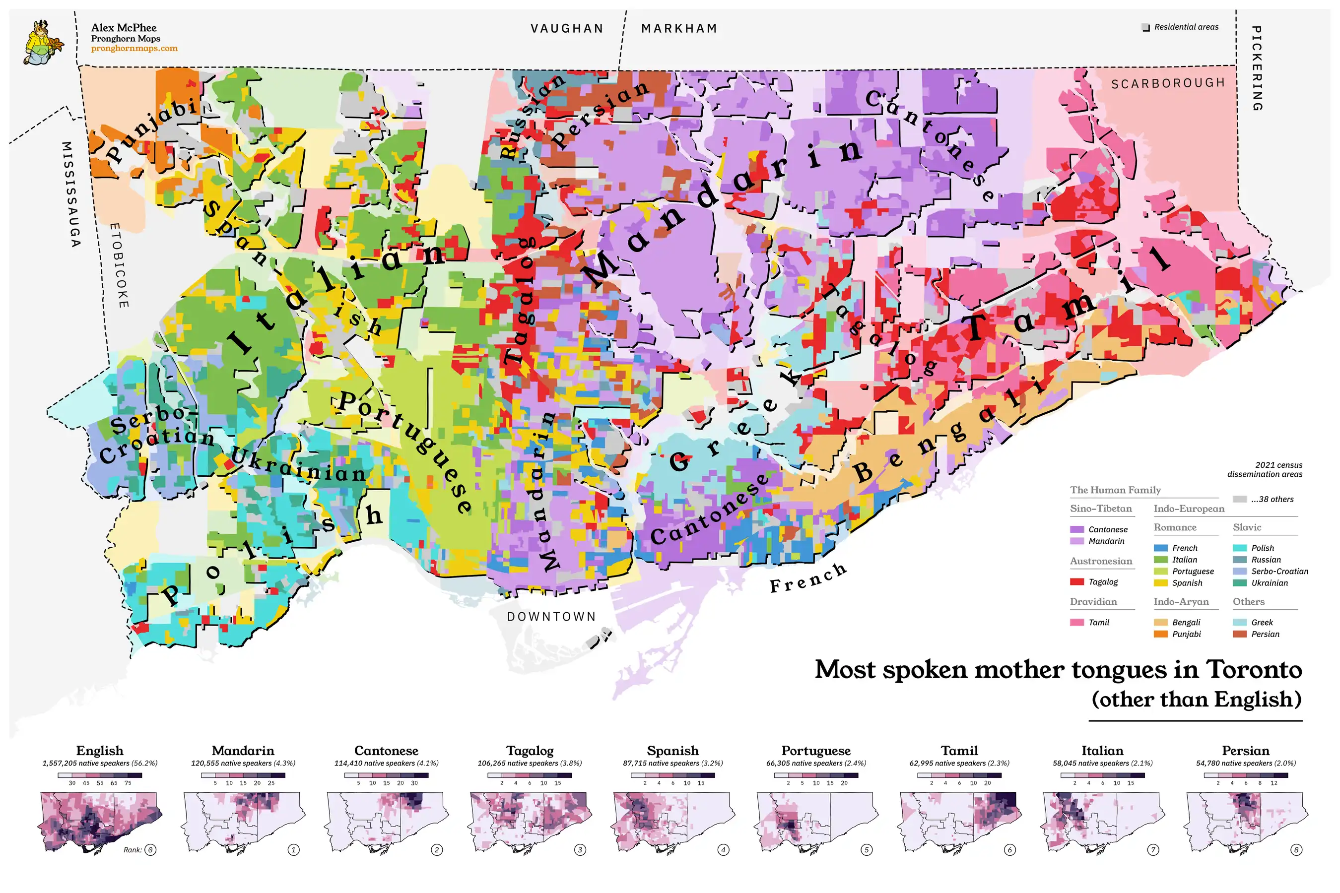
The map above and below are both the work of Alex McPhee, aka Pronghorn maps.

And you can buy both of them on his website here.

[Read more…]

Filed Under: Canada

The 17 Oddest Shaped Countries In The World & How They Came To Be

Last Updated: April 4, 2025 11 Comments

Click To Get My 10 Best Brilliant Maps For Free:

Below is my purely subjective list of the 17 oddest and weirdest shaped countries in world and why they are the shaped the way they are.

17. Italy

[Read more…]

Filed Under: Other

Left Hand Turn At Red Lights Laws By US State & Canadian Province

Last Updated: April 2, 2025 1 Comment

Click To Get My 10 Best Brilliant Maps For Free:

Left Hand Turn At Red Lights Laws By US State & Canadian Province

The map above shows where it is and is not legal to turn left at a red light in the US and Canada. Here’s the key data by state and province according to Wikipedia.

[Read more…]

Filed Under: Canada, United States

The Rise, Fall & Rebirth Of Passenger Rail in Great Britain Over 196 Years

Last Updated: April 2, 2025 Leave a Comment

Click To Get My 10 Best Brilliant Maps For Free:

Video created by reddit user omnomdombomb

The video above shows the growth, then decline and finally the revival of passenger railways in Great Britain over 196 years, from 1825 to 2022.

Below you can see a full list of stations, including the date they opened, whether or not they are still open today and if not when they closed and finally their geographic co-ordinates.

[Read more…]

Filed Under: United Kingdom

China GDP Per Capita By Decade From 1950 To 2020

Last Updated: April 2, 2025 1 Comment

Click To Get My 10 Best Brilliant Maps For Free:

Countries that have been richer or poorer than China since 1950

The map above shows which countries remain richer per person than China in 2020 and which China has overtaken since 1950.

In 1950, China’s GDP per capita in inflation adjusted terms was just $799 per person, making it the 20th lowest in the world.

By 2020 this had risen to $17,226 per person, which still only places it 67th in the world. Here’s how that change looked like over 70 years:

[Read more…]

Filed Under: World Maps

Most Common Origin Country of Immigrants To Western Europe

Last Updated: April 1, 2025 4 Comments

Click To Get My 10 Best Brilliant Maps For Free:

Most Common Origin Country of Immigrants To Different Parts Of Western Europe

Map created by reddit user Min_Noo
The map above shows the flag of the country the origin countries of immigrants to different parts of Europe. I’m not 100% certain on the origin of the data for the map but a quick check looks like it’s fairly accurate.

[Read more…]

Filed Under: Europe

Genetic Map of Greece

Last Updated: April 1, 2025 Leave a Comment

Click To Get My 10 Best Brilliant Maps For Free:

Genetic Map of Greece

Map found on reddit
The map above shows the regional genetic map of Greece based on the DNA from different time periods: Bronze/Iron Age, Roman era, Medieval Slavic, and Ottoman era Turkish.

It comes from this article: A genetic history of the Balkans from Roman frontier to Slavic migrations.

Here are the key things to know:

[Read more…]

Filed Under: Europe

Number of Farm Raised Ducks By US County

Last Updated: April 1, 2025 Leave a Comment

Click To Get My 10 Best Brilliant Maps For Free:

Number of Farm Raised Ducks By US County

Map created by @hdk_maps
The map above shows the number of ducks in each US county used for agricultural purposes (e.g. eggs and meat)  . The data comes from the 2022 USDA Census of Agriculture.

In total there were 3,422,959 farm raised ducks living in the United States that year.

Here’s the data by state and county:

[Read more…]

Filed Under: United States

Number of Alpacas In Each US County

Last Updated: April 1, 2025 Leave a Comment

Click To Get My 10 Best Brilliant Maps For Free:

Number of Alpacas In Each US County

Map created by @HDK_Maps

The map above shows the number of Alpacas living in each US county. The data comes from the 2022 USDA Census of Agriculture.

In total they recorded 87,216 Alpacas living in the US in 851 different US countries. Here are states ranked on the number of alpacas, along with country level data:

[Read more…]

Filed Under: United States

  • « Previous Page
  • 1
  • …
  • 33
  • 34
  • 35
  • 36
  • 37
  • …
  • 152
  • Next Page »


Product Reviews · World Atlas · Settlers of Catan · Risk · Game of Thrones · Coloring Books
Globes · Monopoly · Star Wars · Game of Life · Pandemic · Ticket To Ride · Drinks Cabinets
US Locations · UK Locations· Fleet Management
Copyright © 2026 · Privacy Policy · Fair Use, Attribution & Copyright · Contact Us
Follow Us: Newsletter · Facebook · Youtube · Twitter · Threads · BlueSky · LinkedIn · Instagram · Pinterest · Flipboard