Brilliant Maps

Making Sense Of The World, One Map At A Time

  • BOOK!
  • Newsletter
  • Board Games
  • Posters
  • Scratch Maps

Bird’s Eye View of The City of Ottawa, Ontario (Canada) In 1876

July 27, 2018 Leave a Comment

Bird's Eye View of The City of Ottawa, Ontario (Canada) In 1876

Map created by Herman Brosius, found on Toronto Public Library website

This is a view of Ottawa from 1876, only nine years after it became the capital of what was then known as the Dominion of Canada on July 1, 1867.

In the main diagram the viewer is looking more or less to the south, while the insert in the bottom left is a view of the parliamentary precinct looking roughly north.

[Read more…]

Filed Under: Canada

Canada’s Forgotten Prohibition Plebiscite of 1898

March 20, 2016 1 Comment

Canada's Forgotten Prohibition Plebiscite of 1898

Map originally created by Superbenjamin via Wikimedia, this version created by reddit user Samwell_

The map above shows the outcome of a federal plebiscite on the prohibition of alcohol that was held in Canada on September 29, 1898.

It was the first national referendum in the history of the country. It followed agitation over many decades by the temperance movement, which had succeeded introducing prohibition at the local (county) level in some areas, but wanted it extended nationally.

[Read more…]

Filed Under: Canada, History Tagged With: alcohol

The United States If The Annexation Bill of 1866 Had Passed

February 25, 2016 37 Comments

The United States If The Annexation Bill of 1866 Had Passed

Map created by user Rubberduck3y6 of alternatehistory.com via Wikipedia

The map above shows what an alternate United States might have looked like if the The Annexation Bill of 1866 had passed.

[Read more…]

Filed Under: Canada, Fictional, United States

License Plate Requirements By US State & Canadian Province

November 24, 2015 11 Comments

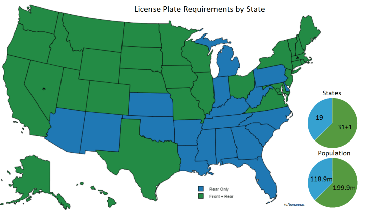
Rear Only vs Front & Rear License Plate Requirements By US State

Rear Only vs Front & Rear License Plate Requirements By US State. Map by reddit user benannas

The map above shows which states require front and rear license plates vs those that only require rear license plates across the US. Overall, the majority of US states (62.75%) and a majority of people (62.73%) live in states that require both.

And in case you’re wondering about the two exceptions they are:

[Read more…]

Filed Under: Canada, United States Tagged With: cars

50% of Canadians Live South of The Red Line

October 8, 2015 14 Comments

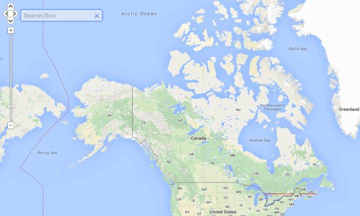
Half of Canada lives south of the red line, or 45.7 degrees north

Map created by reddit user Machetegun

While the 49th parallel is often thought of as the border between the US and Canada, the vast majority of Canadians (roughly 72%) live below it, with 50% of Canadians living south of 45°42′ (45.7 degrees) north or the red line above.

[Read more…]

Filed Under: Canada Tagged With: population

Nunavut is the Largest Electoral District On Earth (8 Times Larger Than The UK)

May 9, 2015 2 Comments

Nunavut electoral district

Map created by ElectionMapper

The UK election may be over, but Canadians are still set to go to the polls on October 19th, 2015 to decide the fate of their own Conservative government. When they do, voters in the Territory of Nunavut will be voting in the world’s largest electoral district.

Just how big is it?

[Read more…]

Filed Under: Canada Tagged With: election


World Atlas · Settlers of Catan · Risk · Game of Thrones · Coloring Books · Globes
Monopoly · Star Wars · Game of Life · Pandemic · Ticket To Ride · Drinks Cabinets
Copyright © 2023 · Privacy Policy · Fair Use, Attribution & Copyright · Contact Us
Follow Us: E-mail · Twitter · Facebook · Pinterest · Flipboard