Brilliant Maps

Making Sense Of The World, One Map At A Time

  • BOOK!
  • Newsletter
  • Board Games
  • Posters
  • Scratch Maps

European Borders In 1914 vs Borders Today

Last Updated: March 3, 2023 9 Comments

Click To Get My 10 Best Brilliant Maps For Free:

European Borders In 1914 vs European Borders Today

Map found via reddit user Areat

The map above shows what Europe’s borders looked on the eve of World War One in 1914, overlaid on top of the borders of European countries today. The first thing that jumps out at you is how many fewer countries there were.

[Read more…]

Filed Under: Border, Europe Tagged With: 1914

Brilliant Art Deco & Brutalist Architecture Maps of London

Last Updated: August 15, 2025 Leave a Comment

Click To Get My 10 Best Brilliant Maps For Free:

Art Deco and Brutalist London Maps

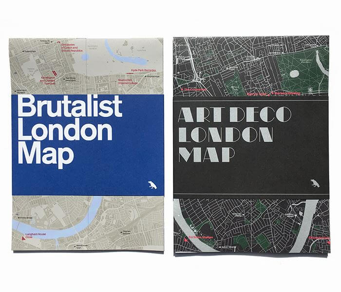
One of the great things about running Brilliant Maps is the ability to profile brilliant, original map projects.

The Art Deco & Brutalist architecture maps of London by Blue Crow Media fall firmly into that category.

[Read more…]

Filed Under: London Tagged With: architecture

How Long Is Great Britain’s Coastline? Well, It Depends…

Last Updated: March 3, 2023 5 Comments

Click To Get My 10 Best Brilliant Maps For Free:

How Long Is Great Britain's Coastline? Well, It Depends...

Map created by Alasdair Rae

According the Ordnance Survey: “The coastline length around mainland Great Britain is 11,072.76 miles [17,819.88 km].”

However, as the map above shows it’s not really that simple.

[Read more…]

Filed Under: United Kingdom

Windyty (Windy.com): Stunning Interactive World Wind & Weather Map

Last Updated: March 3, 2023 5 Comments

Click To Get My 10 Best Brilliant Maps For Free:

Windyty: The Stunning Interactive World Wind & Weather Map

Screenshot of Windyty

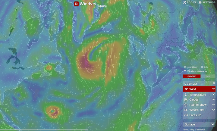
The map above is a screenshot of world wind patterns from Windyty, an absolutely stunning interactive website, that allows you to see global wind and weather patterns.

[Read more…]

Filed Under: World Maps Tagged With: interactive

27 Best Risk Board Game Versions Based On Real Player Reviews

Last Updated: March 12, 2026 8 Comments

Click To Get My 10 Best Brilliant Maps For Free:

Risk is without a doubt the best known and loved, map based board game, of all time. And, while it may not be the highest rated strategy board game, it remains a must-own classic.

However, there’s no reason to limit yourself to the standard board!

Below we look at the 27 best Risk board game versions ranked from best to worst based on real player reviews from Amazon and Boardgamegeek.com.

[Read more…]

Filed Under: Games Tagged With: risk

Since 2000, Every Single Men’s Water Polo Olympic Gold Medallist Has Been Born Within This Circle

Last Updated: July 24, 2025 3 Comments

Click To Get My 10 Best Brilliant Maps For Free:

Since 2000, Every Single Men's Water Polo Olympic Gold Medallist Has Been Born Within This Circle

Map created by 444.hu
While Eastern Europe may not dominate the overall medal table at the Summer Olympics, they do pretty well at Water Polo.

[Read more…]

Filed Under: Sport Tagged With: Olympics

European Population Density: The Black & Blue Areas Have Identical Populations

Last Updated: March 3, 2023 Leave a Comment

Click To Get My 10 Best Brilliant Maps For Free:

European Population Density: The Black & Blue Areas Have Identical Populations

Map created by reddit user joostjakob

As difficult as it is to believe, the black and blue areas above, each have exactly the same number of people living in the them.

[Read more…]

Filed Under: Europe Tagged With: population

Map of The United States in Esperanto

Last Updated: March 3, 2023 8 Comments

Click To Get My 10 Best Brilliant Maps For Free:

Map of The United States in Esperanto

Map source Wikimedia

The map above simply shows the names of each of the states in the United States with their names in Esperanto.

Interestingly, both Ohio and Idaho are spelled the same, although would be pronounced slightly differently than they are in English.

[Read more…]

Filed Under: United States Tagged With: language

Habitability Map of Australia From 1946

Last Updated: November 17, 2025 2 Comments

Click To Get My 10 Best Brilliant Maps For Free:

Habitability Map of Australia From 1946

Map source Vrroom, by the National Archives of Australia, an agency of the Australian Government

The map above shows how habitable various parts Australia are with respect to agriculture and livestock. The scale goes from good agricultural and pastoral lands to the rather direct ‘useless.’

[Read more…]

Filed Under: Australia

Islands of Remain in the Brexit Sea

Last Updated: March 3, 2023 5 Comments

Click To Get My 10 Best Brilliant Maps For Free:

Islands of Remain in the Brexit Isles

Map created by stagyika via DeviantArt

The map above shows the counties of Great Britain (not including Northern Ireland) that voted to remain in the EU following the UK’s referendum on 23 June 2016 as physical islands; islands of remain in the Brexit Sea.

[Read more…]

Filed Under: United Kingdom Tagged With: Brexit

  • « Previous Page
  • 1
  • …
  • 131
  • 132
  • 133
  • 134
  • 135
  • …
  • 155
  • Next Page »


Product Reviews · World Atlas · Settlers of Catan · Risk · Game of Thrones · Coloring Books
Globes · Monopoly · Star Wars · Game of Life · Pandemic · Ticket To Ride · Drinks Cabinets
US Locations · UK Locations· Fleet Management
Copyright © 2026 · Privacy Policy · Fair Use, Attribution & Copyright · Contact Us
Follow Us: Newsletter · Facebook · Youtube · Twitter · Threads · BlueSky · LinkedIn · Instagram · Pinterest · Flipboard