Brilliant Maps

Making Sense Of The World, One Map At A Time

  • BOOK!
  • Newsletter
  • Board Games
  • Posters
  • Scratch Maps

Islands of Remain in the Brexit Sea

Last Updated: March 3, 2023 5 Comments

Click To Get My 10 Best Brilliant Maps For Free:

Islands of Remain in the Brexit Isles

Map created by stagyika via DeviantArt

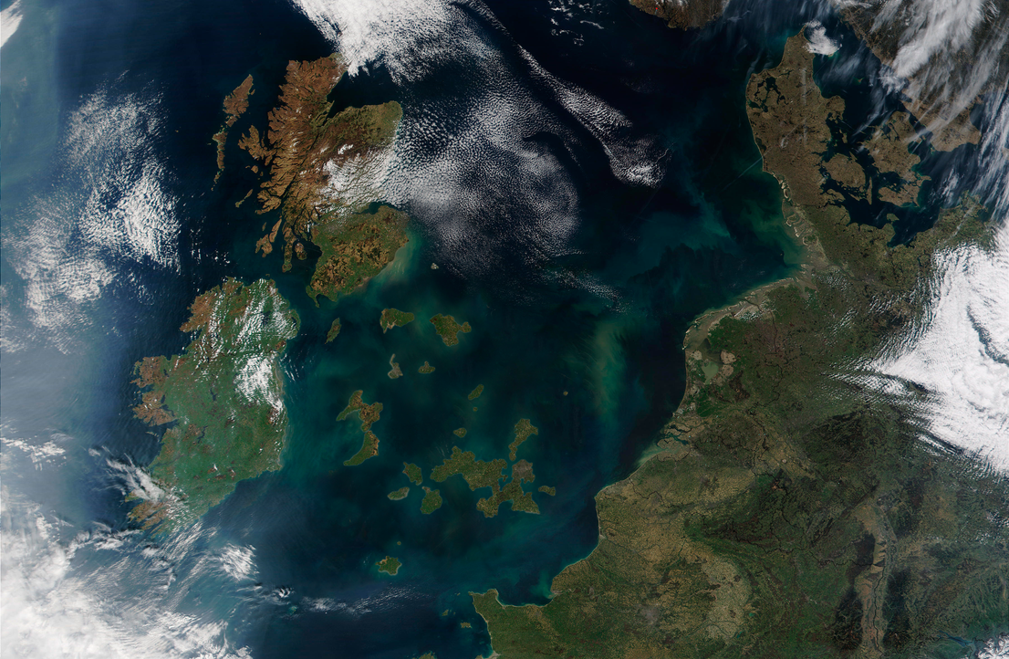
The map above shows the counties of Great Britain (not including Northern Ireland) that voted to remain in the EU following the UK’s referendum on 23 June 2016 as physical islands; islands of remain in the Brexit Sea.

The new post-Brexit Isles would include the island of London (minus Hillingdon, Sutton, Bexley, Barking and Dagenham, and Havering) but which would also include Oxford, Cambridge, Reading and Brighton, the island of Cardiff & Bristol, Isles of Scilly, island of Leicester, island of Manchester, island of Liverpool, island of Leeds & York, Newcastle-on-the-Sea and of course the largest island of all, Scotland.

If you enjoyed this post or hated this post, please share it with a friend and tell them why:

Filed Under: United Kingdom Tagged With: Brexit

Click To Get My 10 Best Brilliant Maps For Free:


Other Popular Maps

  • Countries That Have Been A Setting In One of Shakespeare’s Plays

    Countries That Have Been A Setting In One of Shakespeare’s Plays

  • 95% Of Plastic Polluting The World’s Oceans Comes From These 10 Rivers

    95% Of Plastic Polluting The World’s Oceans Comes From These 10 Rivers

  • 11 Maps Showing How China’s GDP Growth Since 1990 Compares To Other Countries

    11 Maps Showing How China’s GDP Growth Since 1990 Compares To Other Countries

  • What Do Britons Call The Game Where You Knock On Someone’s Door & Run Away

    What Do Britons Call The Game Where You Knock On Someone’s Door & Run Away

  • What Hand Europeans Traditionally Wear Their Wedding Rings On

    What Hand Europeans Traditionally Wear Their Wedding Rings On

  • Percentage of Europeans Who Walk and/or Cycle 30+ Mins Per Day

    Percentage of Europeans Who Walk and/or Cycle 30+ Mins Per Day

  • Railway Lines In the United States On The Eve Of The Civil War

    Railway Lines In the United States On The Eve Of The Civil War

  • 2016 US Presidential Election Map By County & Vote Share

    2016 US Presidential Election Map By County & Vote Share

Comments

  1. Karl W South says

    September 26, 2016 at 5:23 pm

    I can’t help but wonder how different history would have been if this was the actually map of the British Isles. Would there have been a Gaelic Empire instead of the British Empire or would France have filled that role?

    Reply
  2. Tom Blakeman says

    November 14, 2018 at 11:41 pm

    Hi

    Great image – Is it possible to purchase a poster/print of this work?

    Reply
  3. jjstedman says

    June 9, 2020 at 3:05 pm

    Isles of Scilly look a bit large?

    Reply
  4. Gordon D Dudgeon says

    April 23, 2021 at 8:39 am

    Wrong ! At leave 7 Constituencies in NI voted to leave.

    Reply
  5. Gordon David Dudgeon says

    April 23, 2021 at 8:40 am

    sorry At least 7 .

    Reply

Leave a Reply Cancel reply

Your email address will not be published. Required fields are marked *

This site uses Akismet to reduce spam. Learn how your comment data is processed.


Product Reviews · World Atlas · Settlers of Catan · Risk · Game of Thrones · Coloring Books
Globes · Monopoly · Star Wars · Game of Life · Pandemic · Ticket To Ride · Drinks Cabinets
US Locations · UK Locations· Fleet Management
Copyright © 2026 · Privacy Policy · Fair Use, Attribution & Copyright · Contact Us
Follow Us: Newsletter · Facebook · Youtube · Twitter · Threads · BlueSky · LinkedIn · Instagram · Pinterest · Flipboard