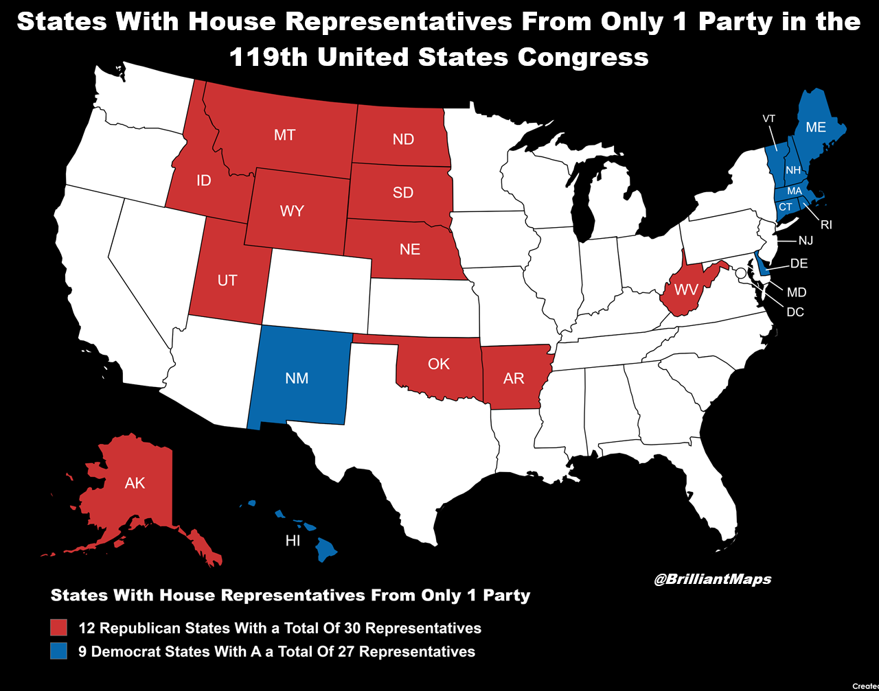
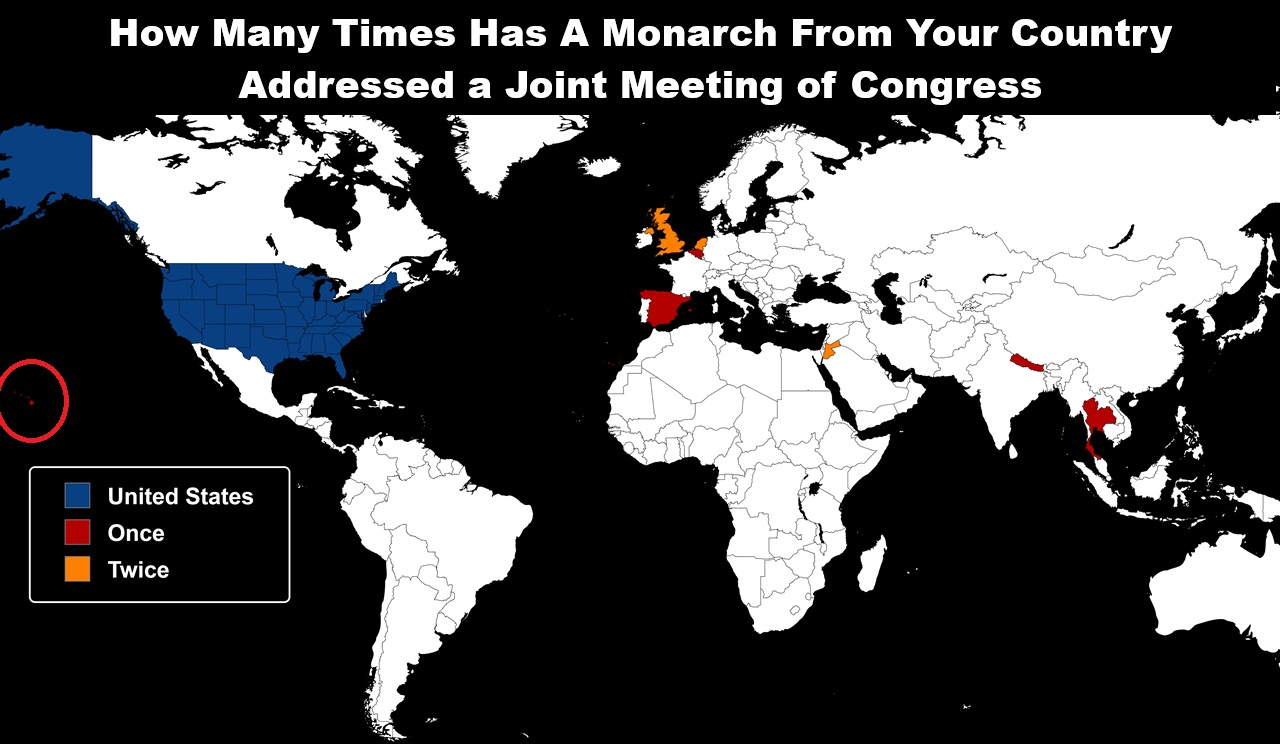
Brilliant Maps

Making Sense Of The World, One Map At A Time

  • BOOK!
  • Newsletter
  • Board Games
  • Posters
  • Scratch Maps

North American Maps for Curious Minds

Last Updated: March 3, 2023 1 Comment

North American Maps for Curious Minds

I’m very please to announce that The Maps for Curious Minds series is back—with 100 vivid infographic maps that transform the way we understand the cultural and historical wonders of North America.

North American Maps for Curious Minds was written by Matthew Bucklan and Victor Cizek and illustrated by Jack Dunnington with a foreword by me (Ian Wright).

Find out the answers to the following questions:

  • Where can you find the world’s tallest and steepest roller coasters?
  • Who is the highest-paid public employee in each state?
  • Where can you visit the world’s largest island in a lake on an island in a lake on an island?
  • Where can you find the world’s biggest geode?
  • Where can you find the world’s oldest, tallest, and largest trees?

and many, many more.

You can find out more about the book from The Experiment here.

And if you’d like to get your own copy, you can do so from the following stores:

  • Amazon
  • Barnes & Noble
  • Books-A-Million
  • Bookshop.org
  • Indigo
  • Powell’s
  • Workman

Filed Under: Other

200 Years Of Us Population Growth In 2 Minutes

Last Updated: March 3, 2023 11 Comments

200 Years Of Us Population Growth In 2 Minutes

Map from VividMaps via Visual Capitalist

According to the 2020 US census there are 331.4 million people living in the United States.

The animated map above shows the growth of US population density from 1790-2010. In 1790, population density was just 4.5 people per sq. mile. But by 2010 it had grown to 87.4 people per sq. mile over a much larger area.

It should be noted that the map above has its shortcomings most notably the fact it doesn’t count Native Americans until they became full US citizens.

And there remains a huge variation in US population density. New Jersey is the densest state with 1,207 people per sq mile, while Alaska has only 1.28 or 1/1000th the population density. Washington DC is even denser at 11,685 people per sq. mile but is not yet a state.

Enjoy this map? Please help by sharing it and leave your comments below:

Filed Under: United States

The Incredible Journey of An Arctic Fox Who Walked From Norway to Canada in 2018

Last Updated: March 3, 2023 Leave a Comment

 Large-scale movements of a young female Arctic fox from Svalbard tracked through Argos satellite telemetry from 1 March to 1 July 2018

Map created by Eva Fuglei & Arnaud Tarroux via Research Gate

The map above shows the incredible journey of one arctic fox in 2018. Over the course of just a few months she walked up to 155km per day all the way from Svalbard (a Norwegian archipelago) to Canada’s Ellesmere Island via Greenland.

You can read the full story here. And see a picture of the fox here.

Find this map interesting? Please help us by sharing it:

Filed Under: Other

A World Map Centered on Argentina

Last Updated: March 3, 2023 4 Comments

A World Map Cantered On Argentina

Map created by CDS_Virtual_Effects

Ever wondered, what would a world map look like if it were centered on Argentina? Well wonder no more. Just have a look at the map above. Of course everything else is incredibly distorted because of the Mercator projection used.

What do you think? Leave your comments below:

Filed Under: World Maps

Second Trump Impeachment Vote (2021): Who Voted For & Against

Last Updated: March 3, 2023 2 Comments

Map created by reddit user Andrew Ellison

The map above shows which Congressional Districts of the 117th Congress voted for or against Donald Trump’s second impeachment by the House of Representatives on January 13, 2021.

[Read more…]

Filed Under: United States

2020 US Presidential Election Map By County & Vote Share

Last Updated: March 3, 2023 22 Comments

2020 US Presidential Election Map By County & Vote Share

Map created by Magog the Ogre via Wikimedia

The map above shows the county level and vote share results of the 2020 US Presidential Election. The darker the blue the more a county went for Joe Biden and the darker the red the more the county went for Donald Trump.

You can see how it compares to the 2016 map here.

[Read more…]

Filed Under: United States

If “Did Not Vote” Had Been A Candidate In The 2020 US Presidential Election

Last Updated: March 3, 2023 11 Comments

If Did Not Vote Had Been A Candidate In The 2020 US Presidential Election

Map created by reddit user Ad8526, based off the 2016 map by Taillesskangaru.

The map above shows what the 2020 US Presidential Election results would have been if votes not cast for Biden, Trump or one of the third party candidates had gone to fictional “Did Not Vote” candidate.

[Read more…]

Filed Under: United States

How The World Might Look In 250 Million Years With Current International Borders

Last Updated: March 3, 2023 9 Comments

How The World Might Look In 250 Million Years With Current International Borders

Map created by Reddit user Coffete

The map is a fun look at what the world might look like in 250 million years time assuming no international borders change between now and then.

[Read more…]

Filed Under: World Maps

Where You Can & Can’t Flush Toilet Paper Around The World

Last Updated: March 3, 2023 34 Comments

Where You Can & Can't Flush Toilet Paper Around The World

Map created by mindofahitchhiker.com

The map above shows where in the world you can and can’t flush your toilet paper in a toilet. The data comes from Where do I put the paper? which describes itself as A handy guide to the world’s toilets.

[Read more…]

Filed Under: World Maps

World Toilet Paper Map Showing Spending On Tissue & Hygiene

Last Updated: March 3, 2023 1 Comment

Toilet Paper Map

Map Created by Euromonitor International

The map above shows the estimated incremental value growth in the tissue and hygiene industry between 2013 and 2018. This includes toilet paper,
Sanitary Protection, nappies/diapers/pants and incontinence products.

[Read more…]

Filed Under: World Maps

  • « Previous Page
  • 1
  • 2
  • 3
  • 4
  • …
  • 38
  • Next Page »


World Atlas · Settlers of Catan · Risk · Game of Thrones · Coloring Books · Globes
Monopoly · Star Wars · Game of Life · Pandemic · Ticket To Ride · Drinks Cabinets
Copyright © 2023 · Privacy Policy · Fair Use, Attribution & Copyright · Contact Us
Follow Us: E-mail · Youtube · Twitter · Facebook · Pinterest · Flipboard