Brilliant Maps

Making Sense Of The World, One Map At A Time

  • BOOK!
  • Newsletter
  • Board Games
  • Posters
  • Scratch Maps

Map Showing the Spread of Christianity Between 33 & 2000AD

Last Updated: March 30, 2026 Leave a Comment

Click To Get My 10 Best Brilliant Maps For Free:

Map Showing the Spread of Christianity Between 33 & 2000AD

Map created by reddit user PanzerMan1002
The map above shows the spread of Christianity around the world and when various areas likely became majority Christian, even if they subsequently no longer are (e.g. North Africa, Turkey and the Middle East).

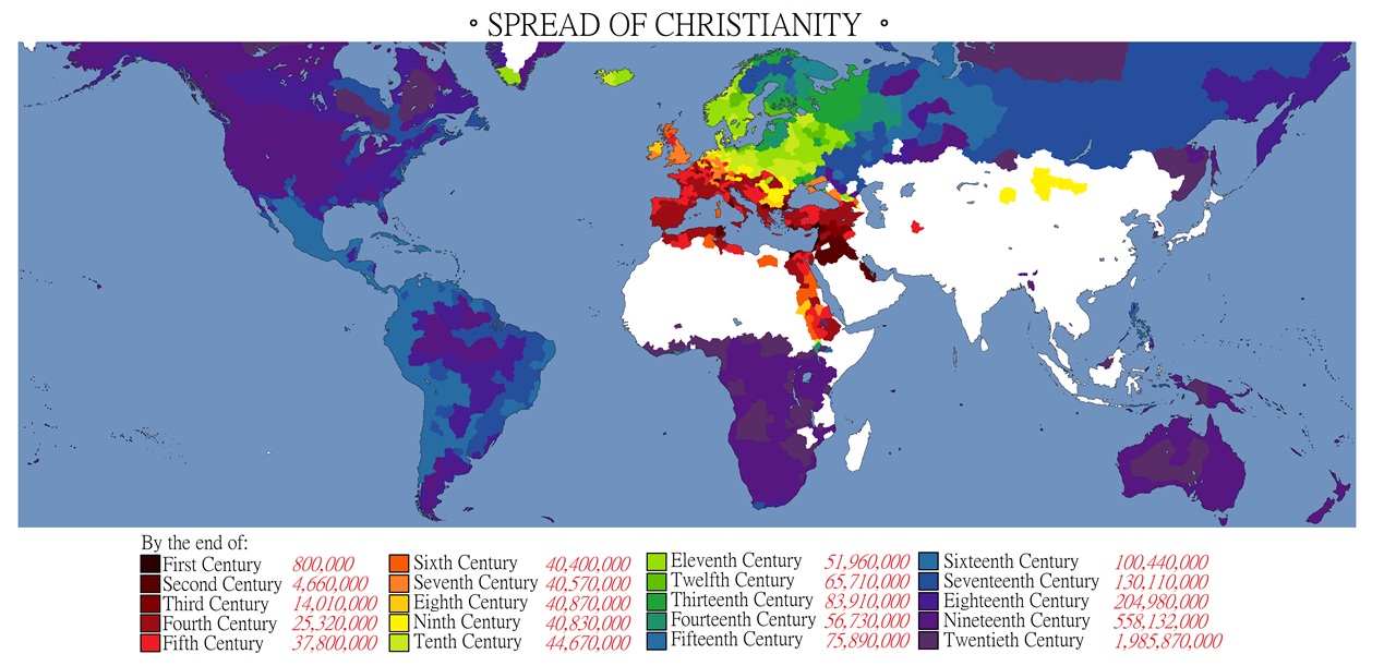
And the overall number of Christians in each century.

The source for the population numbers comes from:

“I Used ‘World Christian Trends, AD 30-AD 2200‘ by David B. Barrett and Todd M. Johnson, which you can find on Google Books, and some other online sources. I tried to use the lowest possible numbers available, so as to filter out more liberal adherent estimates from the early years.”

And as for Madagascar:

“As far as Madagascar is concerned, it’s really tricky to determine exact numbers. Christians in Madagascar often mix their practices with regional paganism, so it’s hard to tell where you draw the line between the two. U.S. Department of State cites a number of 41%, which seems reasonable.”

And Saint Thomas Christians in India?

“The map seeks to show areas that at one time or another were majority Christian. Although Kerala has a huge population of St. Thomas Christians, they never constituted a majority. I think today it’s about 11-15% there.”

Here are the numbers by century:

  • 1st Century: 800,000
  • 2nd Century: 4,660,000
  • 3rd Century: 14,010,000
  • 4th Century: 25,320,000
  • 5th Century: 37,800,000
  • 6th Century: 40,400,000
  • 7th Century: 40,570,000
  • 8th Century: 40,870,000
  • 9th Century: 40,830,000
  • 10th Century: 44,670,000
  • 11th Century: 51,960,000
  • 12th Century: 65,710,000
  • 13th Century: 83,910,000
  • 14th Century: 56,730,000
  • 15th Century: 75,890,000
  • 16th Century: 100,440,000
  • 17th Century: 130,110,000
  • 18th Century: 204,980,000
  • 19th Century: 558,132,000
  • 20th Century: 1,985,870,000

What do you think of the map?

Filed Under: World Maps

Click To Get My 10 Best Brilliant Maps For Free:


Other Popular Maps

  • Who Did Better Against Trump: Clinton Or Harris?

    Who Did Better Against Trump: Clinton Or Harris?

  • Did you Know There Are “Rogue Holes” In The Ocean In Addition To “Rogue Waves”

    Did you Know There Are “Rogue Holes” In The Ocean In Addition To “Rogue Waves”

  • Number Of Times Each State Has Been Admitted Into The United States

    Number Of Times Each State Has Been Admitted Into The United States

  • Number of Cities With A Tram System in Europe

    Number of Cities With A Tram System in Europe

  • How Far From London Can You Get By Train In 12 Hours

    How Far From London Can You Get By Train In 12 Hours

  • 16 Declassified CIA Cartography Maps From The 2000s

    16 Declassified CIA Cartography Maps From The 2000s

  • Video Showing The Emancipation Of Women Between 1720 & 2023

    Video Showing The Emancipation Of Women Between 1720 & 2023

  • Mexico Divided By Stereotypes

    Mexico Divided By Stereotypes

Leave a Reply Cancel reply

Your email address will not be published. Required fields are marked *

This site uses Akismet to reduce spam. Learn how your comment data is processed.


Product Reviews · World Atlas · Settlers of Catan · Risk · Game of Thrones · Coloring Books
Globes · Monopoly · Star Wars · Game of Life · Pandemic · Ticket To Ride · Drinks Cabinets
US Locations · UK Locations· Fleet Management
Copyright © 2026 · Privacy Policy · Fair Use, Attribution & Copyright · Contact Us
Follow Us: Newsletter · Facebook · Youtube · Twitter · Threads · BlueSky · LinkedIn · Instagram · Pinterest · Flipboard