Brilliant Maps

Making Sense Of The World, One Map At A Time

  • BOOK!
  • Newsletter
  • Board Games
  • Posters
  • Scratch Maps

Map Of East Germany’s One And Only Free & Fair Election

Last Updated: April 9, 2026 Leave a Comment

Click To Get My 10 Best Brilliant Maps For Free:

Results of the 1990 East German Election

Credit: Erinthecute
The map above shows the one and only free and fair election in East German’s entire history on 18 March 1990.

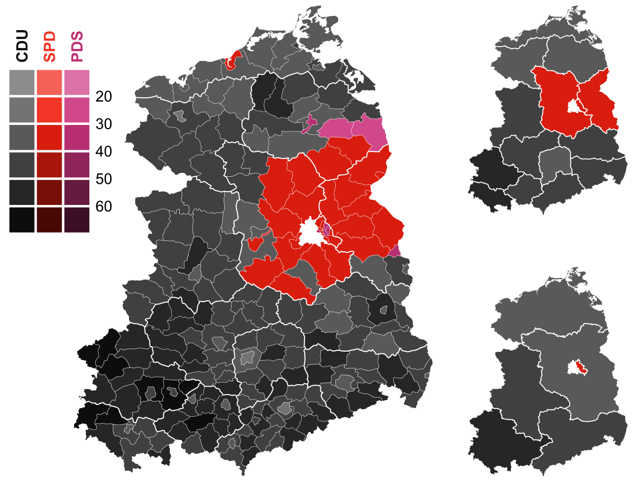
East Germany would join West Germany later that year on October 3rd.

More about this election and more maps below:

[Read more…]

Filed Under: Germany

All Saints Day vs Reformation Day In Germany

Last Updated: October 31, 2025 Leave a Comment

Click To Get My 10 Best Brilliant Maps For Free:

All Saints Day vs Reformation Day In Germany

Credit The World In Maps
The map above shows another German split between states that celebrate All Saints Day’s and those that celebrate Reformation Day in Germany (and those that celebrate neither).

More about each below:

[Read more…]

Filed Under: Germany

1932 vs 2025 German Election Results

Last Updated: February 24, 2025 Leave a Comment

Click To Get My 10 Best Brilliant Maps For Free:

1932 vs 2025 German Election Results

The two maps above show the German Reichstag election results of 31 July 1932 election compared to the results of the 23 February 2025 ones.

The 1932 election was notable as it was the first time the time the Nazi won the biggest share of the vote, although they fell far short of a majority, which they never achieved in any free and fair election.

Here are the results of the two elections:

[Read more…]

Filed Under: Germany

The Racoon Invasion Of Germany

Last Updated: February 19, 2025 1 Comment

Click To Get My 10 Best Brilliant Maps For Free:

The Racoon Invasion Of Germany

Map crated by sashas_maps
The map above shows how racoons (which are not native to Europe) have slowly been spreading across Germany.

As of 2024, it was estimated that there were over 2 million racoons in the country, but the government is seeking to euthanized them.

Until coming across this map I had no idea that racoons could be found anywhere in Europe, let alone in such big numbers.

So how did they get here?

[Read more…]

Filed Under: Germany

German Language Areas of Europe 1910 vs 2010

Last Updated: November 25, 2025 1 Comment

Click To Get My 10 Best Brilliant Maps For Free:

German Language Areas of Europe 1910 vs 2010

The map above shows what starting and losing two world wars did to the distribution of the German language throughout Europe between 1910 and 2010.

[Read more…]

Filed Under: Germany

Map of German Territorial Losses 1919-1945

Last Updated: January 13, 2026 1 Comment

Click To Get My 10 Best Brilliant Maps For Free:

Map of German Territorial Losses 1919-1945

Map created by Aeroid
The map above shows just how much of Germany was lost between then end of the Second Reich in 1919 and the end of the Third Reich in 1945. It also shows the divisions of both Berlin and East and West Germany.

In 1910, Germany was 540,857.54 km2 (208,826.26 sq mi) and had a population of 64,925,993.

[Read more…]

Filed Under: Germany

Religion in Germany Map By State: Protestants vs Catholics vs Not Religious

Last Updated: March 30, 2026 2 Comments

Click To Get My 10 Best Brilliant Maps For Free:

Religion in Germany By State: Protestants vs Catholics Vs Not Religious

Map found on reddit
The maps above show the religious composition of Germany by state, divided into three categories: Protestant, Catholic, and Not religious.

The percentages represent the proportion of each category within the respective states.

[Read more…]

Filed Under: Germany

Most Common Nationality Other Than German In Each State Of Germany (2024)

Last Updated: May 9, 2025 Leave a Comment

Click To Get My 10 Best Brilliant Maps For Free:

Most Common Nationality Other Than German In Each State In Germany

Map created by reddit user dphayteeyl
This map shows the most common nationality other than German in each of the German Bundesländer (federal states).

The color coding represents different nationalities:

  • Red: Turkey
  • Yellow: Ukraine
  • Blue: Romania
  • Green: Syria

Here is the detailed information for each German state based on the map:

[Read more…]

Filed Under: Germany

1988 East German Map of West Berlin

Last Updated: March 3, 2023 7 Comments

Click To Get My 10 Best Brilliant Maps For Free:

1988 East German Map of West Berlin

Map found at HERE 360

The map above is one of our favourites. It shows (or rather doesn’t show) West Berlin in 1988. It was published in East Germany just one year before the fall of the Berlin Wall.

[Read more…]

Filed Under: Germany, History

Germany (And The World) Divided By Aldi Nord (North) vs Aldi Süd (South)

Last Updated: March 20, 2026 8 Comments

Click To Get My 10 Best Brilliant Maps For Free:

Germany Divided By Aldi

Map created by Kyro via Wikimedia
While the Berlin Wall may have fallen nearly 30 years ago, Germany remains a nation divided. But instead of East vs West, the division is between North and South, specifically Aldi Nord vs Aldi Süd.

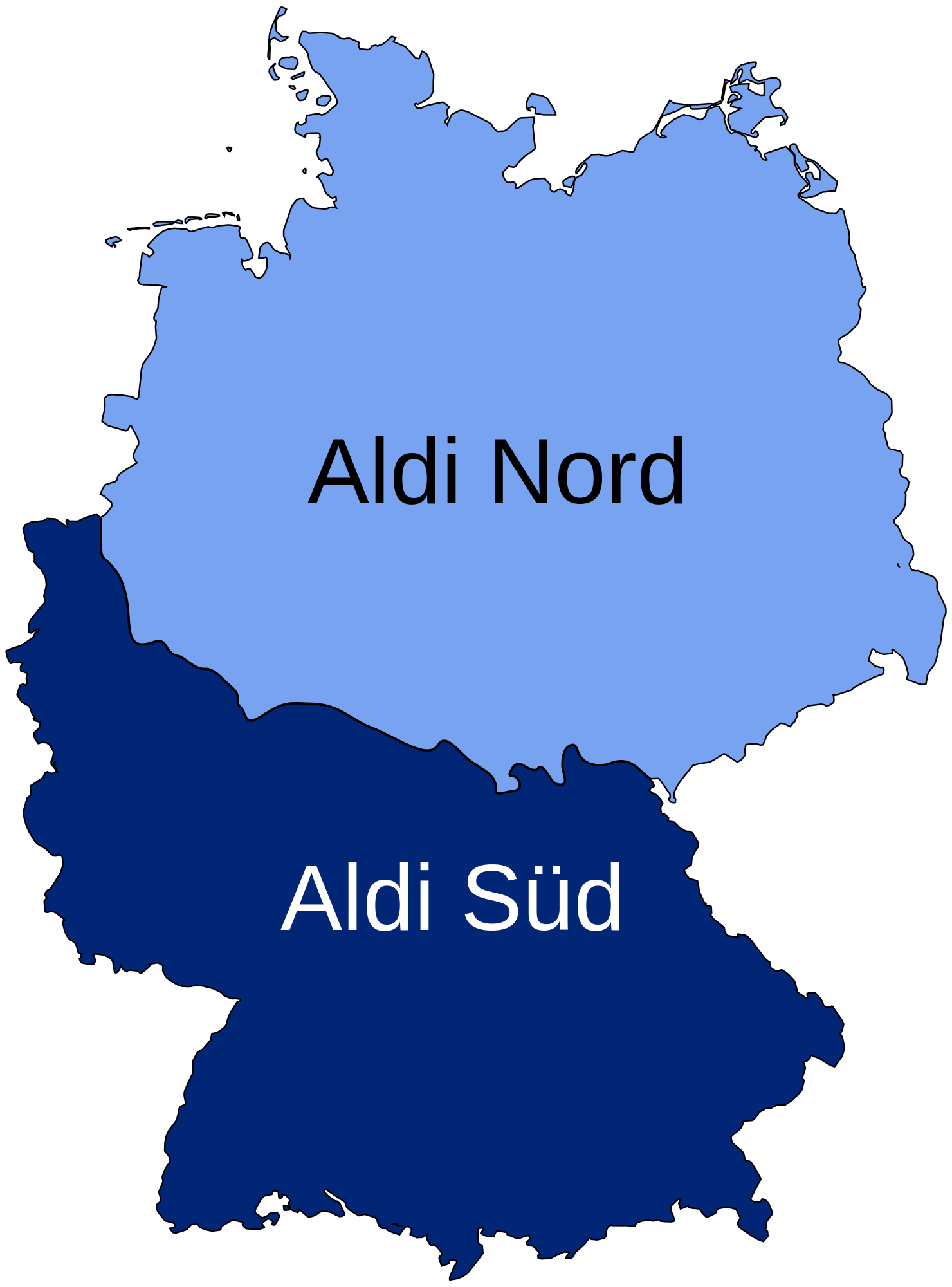
And in case you were wondering, this is not some sort of regional division. The two companies are legally separate entities that both use the Aldi name.

[Read more…]

Filed Under: Germany, World Maps

  • 1
  • 2
  • Next Page »


Product Reviews · World Atlas · Settlers of Catan · Risk · Game of Thrones · Coloring Books
Globes · Monopoly · Star Wars · Game of Life · Pandemic · Ticket To Ride · Drinks Cabinets
US Locations · UK Locations· Fleet Management
Copyright © 2026 · Privacy Policy · Fair Use, Attribution & Copyright · Contact Us
Follow Us: Newsletter · Facebook · Youtube · Twitter · Threads · BlueSky · LinkedIn · Instagram · Pinterest · Flipboard