
The color coding represents different nationalities:
- Red: Turkey
- Yellow: Ukraine
- Blue: Romania
- Green: Syria
Here is the detailed information for each German state based on the map:
- Schleswig-Holstein: Ukraine (Yellow)
- Hamburg: Turkey (Red)
- Lower Saxony (Niedersachsen): Ukraine (Yellow)
- Bremen: Turkey (Red)
- North Rhine-Westphalia (Nordrhein-Westfalen): Turkey (Red)
- Hesse (Hessen): Turkey (Red)
- Rhineland-Palatinate (Rheinland-Pfalz): Turkey (Red)
- Baden-Württemberg: Turkey (Red)
- Bavaria (Bayern): Romania (Blue)
- Saarland: Syria (Green)
- Berlin: Turkey (Red)
- Brandenburg: Ukraine (Yellow)
- Mecklenburg-Vorpommern: Ukraine (Yellow)
- Saxony (Sachsen): Ukraine (Yellow)
- Saxony-Anhalt (Sachsen-Anhalt): Ukraine (Yellow)
- Thuringia (Thüringen): Ukraine (Yellow)
Data was taken from 2022 or 2023.
Here’s a alterative map that shows the largest immigrant communities by region, not necessarily nationality.

The only real difference is Bavaria, which as of 2023 did have more Romanians than Turkish nationals living there, but again that looks at nationality rather than ethnicity (which is not recorded in the German Census).
Given that the numbers are very close, and Turkish emigration to Germany started earlier it’s likely there are more ethnic Turks living in Bavaria than Romanians.
And finally, Share of the German Population with a Migrant Background:
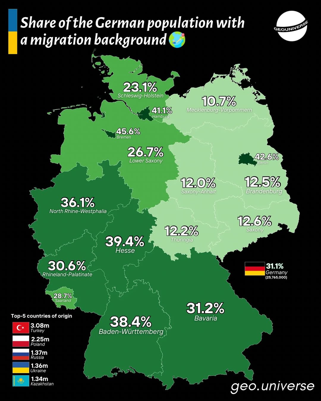
From the original Instagram post:
Did you know nearly 1 in 3 people in Germany has a migration background?
That’s 31.1% of the population — over 25.7 million people — making Germany one of Europe’s most diverse nations.
Here’s how it breaks down by state 👇
🏙️ City-states lead the pack:
Bremen 45.6% · Hamburg 41.1% · Berlin 42.6%
📍 Western states not far behind:
Hesse 39.4% · Baden-Württemberg 38.4% · NRW 36.1%
🌿 Eastern states are much lower:
Mecklenburg-Vorpommern 10.7% · Thuringia 12.2% · Saxony-Anhalt 12.0%
Top countries of origin:
🇹🇷 Turkey – 3.08M
🇵🇱 Poland – 2.25M
🇷🇺 Russia – 1.37M
🇺🇦 Ukraine – 1.36M
🇰 Kazakhstan – 1.34MGermany’s diversity tells a story of decades of migration, labor, refuge, and rebuilding. Every percentage point is millions of lives and histories.
What are your thoughts on the map? Please leave your comments below:


John Cartwright says
How does it define “migrant background”?