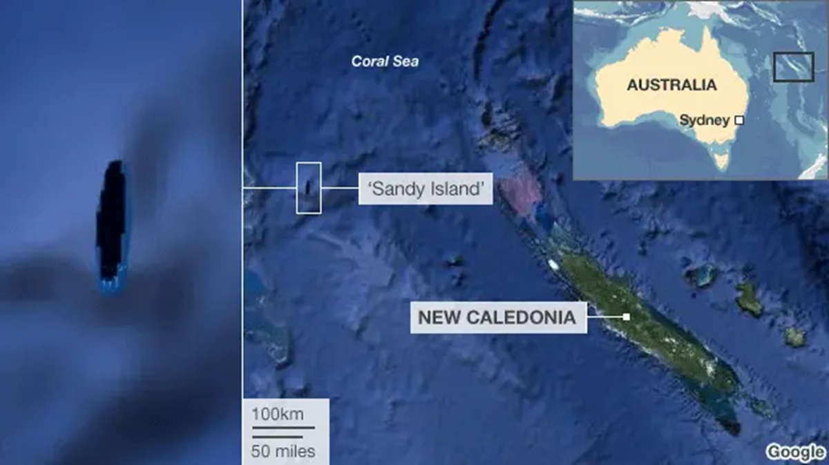
More about the story below:
Sandy Island is one of the most famous phantom islands—a place that appeared on maps for over a century but turned out not to exist at all.
It was supposedly located in the Coral Sea, northwest of New Caledonia.
How it ended up on maps
Early sightings (18th–19th century)
- The story likely begins with Captain James Cook (1774), who noted a vague “sandy island” in the region.
- The whaling ship Velocity (1876) later reported “heavy breakers” and “sandy islets.”
These reports were:
- based on rough navigation (no GPS)
- possibly misinterpretations of reefs, waves, or floating debris
Cartographic snowball effect
Once reported:
- It was added to Admiralty charts (early 1900s) and atlases
- Later mapmakers copied earlier maps instead of verifying the island
- Some charts even marked it “ED” (existence doubtful)
This is a classic mapping problem: errors get inherited and amplified over time
Why it appeared on Google Maps & Google Earth
Even in the modern era, Sandy Island survived because of data pipelines:
- Old charts were digitised into databases like the World Vector Shoreline Database (WVS)
- These datasets were used by:
- Google Earth
- Google Maps
- even military and scientific maps
On Google Earth, it showed up as a:
- solid black polygon, not a photographed island
Key point: Google didn’t “see” the island, it trusted inherited data.
The “undiscovery” (2012)
In November 2012, scientists aboard the research ship Southern Surveyor went to find it.
What happened:
- They sailed directly to the coordinates
- Found open ocean, no land at all
- Measured depth: ~1,300–1,400 meters deep
That depth proves:
- the island could not have sunk
- it was never there in the first place
This event is often called the “undiscovery” of Sandy Island.
So what did sailors actually see?
No single explanation is confirmed, but leading theories include:
1. Floating pumice raft
- After underwater volcanic eruptions, huge floating rock masses can form
- These can look like land from a distance
2. Reef or wave illusions
- “Heavy breakers” may have been waves crashing over submerged reefs
- From afar, this can resemble land
3. Navigation errors
- 19th-century positioning could be off by tens of miles
- Reports may have been misplaced geographically
Most likely: a mix of observation error + misreporting + map copying
Why it lasted so long
Sandy Island survived for over 100 years because:
- Remote location (few ships passed through)
- Mapmakers trusted earlier sources
- Digital systems inherited old mistakes
- Conflicting maps caused uncertainty
Even:
- French charts removed it in the 1970s …but others kept it, so the error persisted.
Its removal
After 2012:
- Scientists published findings
- Google and others removed it within days
- Mapping agencies updated their data
Why this story matters
Sandy Island is a perfect example of:
- How errors can survive centuries
- How technology depends on data quality
- Why even modern maps aren’t infallible
News Stories about it from 2012:
BBC: South Pacific Sandy Island ‘proven not to exist’
Sunday Morning Herald: Where Did it Go?





Leave a Reply