
Size Comparison of Roman & Ottoman Empires At Their Peak

The map uses three colors to represent areas:
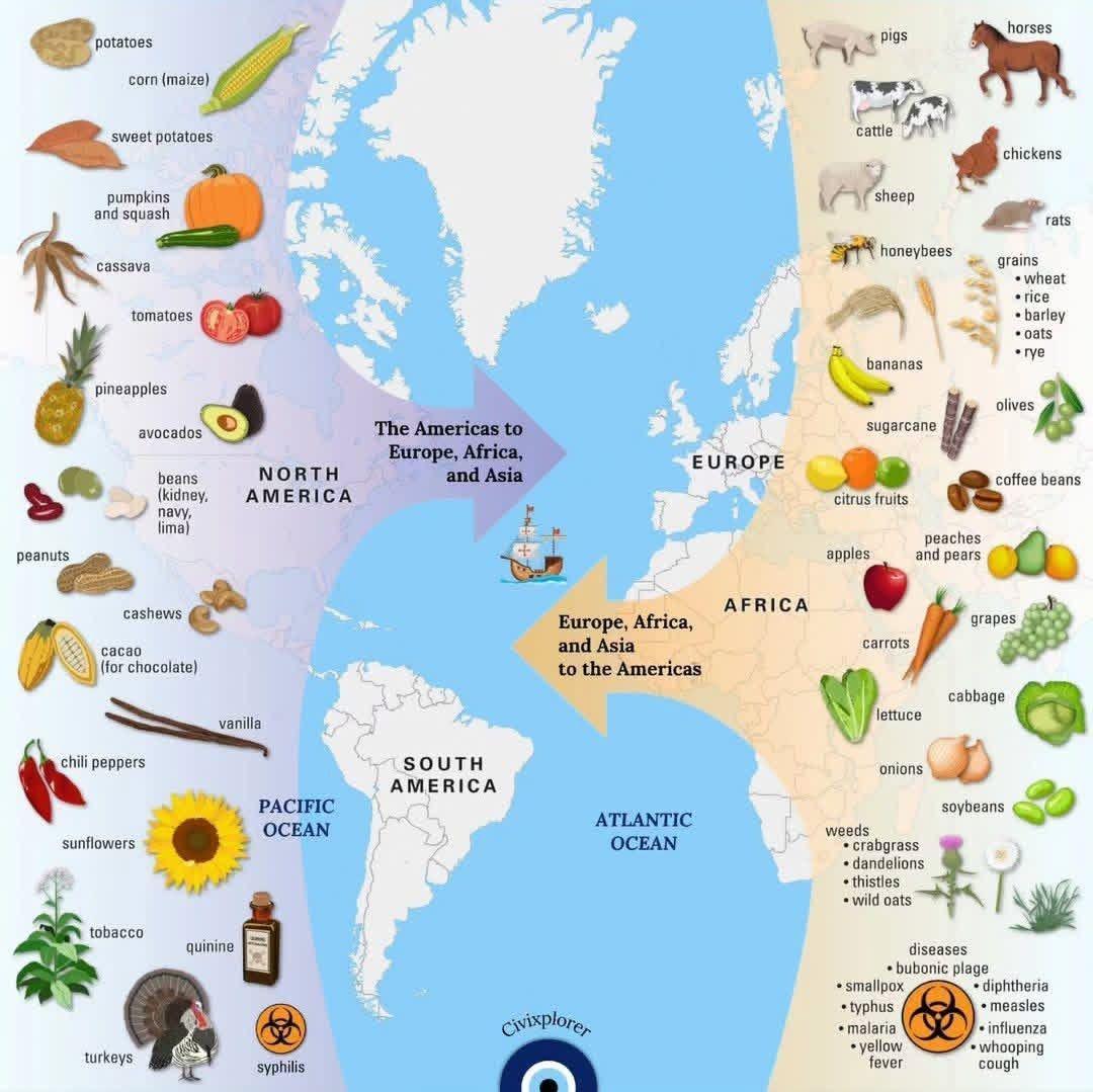
Map Of The Columbian Exchange

The exchange represents the widespread transfer of plants, animals, culture, human populations, technology, and diseases between the Americas, Europe, Africa, and Asia.
Key Points in the Graphic:
- Items Transferred from the Americas (North and South) to Europe, Africa, and Asia:
- Crops: Potato, Corn, beans, squash, tomato, peanut, cassava, avocado, sweet potato, peppers, pineapple, and pumpkin.
- Livestock/Animals: Turkey.
- Other: tobacco, cacao bean, vanilla, and quinine (a treatment for malaria)
- Items Transferred from Europe, Africa, and Asia to the Americas:
- Crops: Wheat, rice, barley, oats, sugar cane, banana, coffee bean, peach, pear, olive, citrus fruits, grape, onion, and turnip.
- Livestock/Animals: Livestock like cattle, sheep, pig, and horse; honeybee.
- Diseases: Smallpox, influenza, typhus, measles, malaria, diphtheria, and whooping cough.
Significance:
The Columbian Exchange profoundly transformed food and cuisine across all continents, leading to significant changes in diets, agriculture, and culinary traditions.
Here’s how it affected each continent:
The Americas:
- Introduction of European Crops and Livestock:
- Before the Columbian Exchange, the Americas lacked domesticated animals like cattle, pigs, and horses. The arrival of these animals introduced new sources of protein and fundamentally changed agricultural practices.
- Wheat, rice, and barley became staple crops in many regions, especially in North America, influencing the development of bread-based diets and cuisines.
- New Culinary Traditions: European grains and livestock combined with Indigenous crops like corn, beans, and potatoes led to the development of hybrid cuisines, such as dishes that blended European techniques with Native American ingredients.
Europe:
- Increased Variety and Nutrition:
- The introduction of staple crops like potatoes, tomatoes, maize (corn), and beans revolutionized European diets. The potato, in particular, became a crucial food source in countries like Ireland and Russia, leading to population growth and improved nutrition.
- Tomatoes transformed Mediterranean cuisine, leading to dishes like Italian pasta with tomato sauce and Spanish gazpacho. Chocolate (from cacao beans) and vanilla became luxury items and later integral parts of European desserts.
- Expansion of Global Trade: The demand for sugar from the New World led to the establishment of large plantations in the Caribbean, reshaping global trade and cuisine through the widespread availability of sweetened foods.
Africa:
- Introduction of New Crops: Maize (corn), cassava, and peanuts became essential crops in many parts of Africa, where they adapted well to local climates. Cassava and maize, in particular, became staple foods in West and Central Africa, significantly impacting local cuisines and diets.
- Dietary Changes: The introduction of these calorie-dense crops led to population growth in certain regions. Traditional African dishes like fufu and various porridges started incorporating these new ingredients.
Asia:
- Adoption of New Ingredients: Crops like chili peppers, sweet potatoes, and peanuts were introduced from the Americas and quickly integrated into Asian cuisines. Chili peppers, for example, became integral to Indian, Thai, and Chinese cooking, transforming spice blends and flavor profiles.
- Expansion of Staple Crops: The introduction of maize, potatoes, and sweet potatoes in China helped sustain large populations, especially in areas where rice or wheat cultivation was difficult.
General Impact Across Continents:
- Globalization of Ingredients: Foods that were once region-specific became global staples. For instance, Italian, Indian, and Thai cuisines are unimaginable without tomatoes or chili peppers, which originated in the Americas.
- Fusion and Hybrid Cuisines: The blending of indigenous and introduced ingredients led to new culinary traditions. For example, Creole cuisine in the Caribbean is a mix of African, European, and Native American influences.
- Increased Food Security and Population Growth: The introduction of high-calorie crops like potatoes and maize led to better food security in Europe, Asia, and Africa, fueling population booms and the growth of cities.
Here’s another map showing the process:
The Protestant Reformation In Europe At Its Peak (1545-1620)

Here’s a detailed breakdown of what the map shows about the spread of Protestantism during this period:
Map of The Korean War In 60 Seconds
Map created by Maps in A Nutshell.
Here’s a timeline highlighting key events and the moments when both sides came close to losing the war:
Map Of The Largest Towns And Cities Of England In 1377

Here is a detailed explanation:
Map Showing The Ancestry Of US Presidents

I used genealogy resources to track their ancestors to approximately 10 generations, or until the information disappears. Then I noted which countries their ancestors came from.
Virtually all of them had ancestry from many countries, not just one.
Here is a list of countries and the number of presidents with ancestry from each:
Watch WW2 In Europe With Army Sizes In Just 60 Seconds
The video above provides a concise overview of World War II in Europe, focusing on the troop strengths of various sides. It highlights the major military forces involved in the conflict, including the Allies and the Axis powers.
You can watch the sped up version below which shows everything above in just 60 seconds.
Extremely Detailed English Map Of The Paris Catacombs

The map above shows an incredibly detailed map, in English, of the Paris Catacombs. It appears to have been made by a French company called CUBE that no longer seems to be in business.
Here is some of the extracted text (note this was done by software so may have some errors). You can read the map in full by clicking on it above:
Map Of Every Colonial Battle Fought By UK, France, Spain, Portugal & The Netherlands

Longjumping_Care989
Here are the major colonial battels fought by each country:
- « Previous Page
- 1
- 2
- 3
- 4
- 5
- 6
- …
- 9
- Next Page »