Map created by Maps in A Nutshell.
Here’s a timeline highlighting key events and the moments when both sides came close to losing the war:
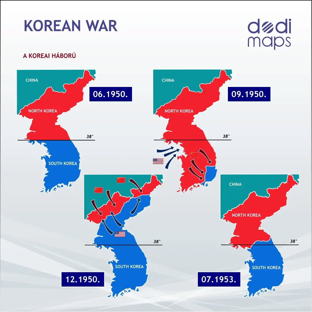
1. Outbreak and Initial North Korean Success (June 1950)
- June 25, 1950: North Korean forces crossed the 38th parallel, invading South Korea, leading to the start of the Korean War.
- June-July 1950: North Korea, backed by the Soviet Union, quickly advanced southward, capturing Seoul (the South Korean capital) and pushing South Korean forces and a small contingent of U.S. troops into a small perimeter around Pusan, in the southeastern corner of the peninsula.
South Korea’s Near Defeat:
- By August 1950, South Korea was on the brink of defeat, with North Korean forces having captured nearly the entire peninsula. The Pusan Perimeter, where U.N. forces (primarily American and South Korean) made a stand, was the last stronghold.
2. U.N. Counteroffensive and the Recapture of Seoul (September 1950)
- September 15, 1950: General Douglas MacArthur launched the successful amphibious landing at Inchon, a port city near Seoul. This operation surprised the North Koreans and cut their supply lines.
- September 25, 1950: Seoul was recaptured by U.N. forces.
- October 1950: U.N. forces, now advancing beyond the 38th parallel, pushed deep into North Korea, capturing Pyongyang and approaching the Yalu River, the border with China.
North Korea’s Near Defeat:
- By October 1950, North Korea was on the verge of total collapse as U.N. forces approached the Chinese border.
3. Chinese Intervention and U.N. Retreat (November 1950 – January 1951)
- October-November 1950: The Chinese People’s Volunteer Army (PVA) entered the war in support of North Korea, launching a massive counteroffensive.
- November-December 1950: U.N. forces, unprepared for the large-scale Chinese intervention, were pushed back across the 38th parallel. Seoul was recaptured by communist forces in January 1951.
U.N. and South Korea’s Second Near Defeat:
- The sudden and overwhelming Chinese intervention forced U.N. forces into a desperate retreat, and by January 1951, the situation was critical for South Korea once again, with Seoul under communist control.
4. Stalemate and Attrition (1951-1953)
- March 1951: U.N. forces regrouped and recaptured Seoul in March, stabilizing the front near the 38th parallel.
- July 1951 – July 1953: The war settled into a bloody stalemate, with neither side able to gain significant ground. The front line remained near the 38th parallel for the remainder of the war.
Continued Stalemate:
- Both sides faced immense casualties, but neither was close to winning or losing completely after early 1951. The front lines remained largely static despite ongoing battles.
5. Armistice and End of Hostilities (July 1953)
- July 27, 1953: An armistice was signed, effectively ending the Korean War. The border between North and South Korea was established near the 38th parallel, close to its original pre-war location.
The Korean War was a conflict of dramatic reversals, where both North and South Korea came perilously close to total defeat. South Korea nearly fell in the summer of 1950, saved only by the U.N. intervention and the successful Inchon landing.
North Korea was almost defeated by U.N. forces in late 1950 before the Chinese intervention reversed the war’s momentum.
The subsequent two years of stalemate and attrition underscored the difficulty of achieving a decisive victory in the rugged terrain of the Korean Peninsula.
And in summary here is the Korean War in 4 parts:


Leave a Reply