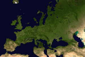
The video above shows the evolution of France’s borders between 985 and 1947, when it finally arrived at the boarders it still has in 2025.
Here are some of the major key dates:
1) 985
Context: This is near the start of the Capetian dynasty (Hugh Capet crowned in 987).
- Key point: The map shows how little the French king directly controlled in the late 900s.
2) Early 1000s
Context: Gradual consolidation under the early Capetians, though territory growth is modest. Sometimes historians mark 1032 because of inheritances in Burgundy (the Kingdom of Arles/Burgundy joined the Holy Roman Empire, but parts of it drifted under French influence).
- Key point: Very slow centralization; the crown is still relatively weak compared to its great vassals.
3) Late 1100s (c. 1180) – Accession of Philip II (Philip Augustus)
Context: Philip II Augustus (r. 1180–1223) begins systematically to recover royal control over Normandy, Anjou, Maine, and Touraine from the Plantagenets (the “Angevin Empire”).
- Key point: The frame often shows a small but growing “blob” around the Île‐de‐France and expansions into the north and west.
4) 1204 – Conquest of Normandy and Western Lands
Context: Philip II conquers Normandy, Maine, Anjou, and Touraine from King John of England around 1204.
- Key point: A major expansion of the royal domain westward, effectively splitting the Angevin possessions in two.
5) 1220s–1230s – Albigensian Crusade and Treaty of Paris (1229)
Context: Royal authority expands in the south after the Albigensian (Cathar) Crusade. In 1229, the Count of Toulouse submits to the French crown.
- Key point: Large swaths of Languedoc come under direct royal control.
6) 1271 – Appanages Reverting to Crown
Context: Alphonse of Poitiers (brother of Louis IX) dies, and his vast lands (including Toulouse) revert to the crown.
- Key point: Consolidates nearly all of southern France under Capetian rule.
7) Hundred Years’ War Begins (1337)
Context: Before the war’s major losses, France is large but about to face the English claim to the throne.
- Key point: No immediate huge boundary shift here, but the frame might mark the situation just before the major fighting.
8) 1360 – Treaty of Brétigny
Context: In the midst of the Hundred Years’ War, England forces France to cede a large swath of southwestern France.
- Key point: You’ll see a big “bite” taken out of France in Aquitaine.
9) Late 1300s – Reconquest Under Charles V
Context: Charles V (r. 1364–1380) and his generals recover most of the lands lost at Brétigny.
- Key point: The French map regains southwestern regions, though Calais remains English.
10) Early 1400s – English Conquests (Henry V)
Context: Another reversal during the Hundred Years’ War: Henry V of England conquers Normandy (1417–1419). The Treaty of Troyes (1420) disinherits the Dauphin.
- Key point: Northern France (including Paris) and parts of the northwest come under English or Burgundian control.
11) 1453 – End of the Hundred Years’ War
Context: After Joan of Arc’s interventions and subsequent French victories, the English hold in France collapses (except Calais).
- Key point: France recovers nearly all territory, with only Calais remaining under English control.
12) 1477 – Death of Charles the Bold
Context: The Duchy of Burgundy’s ruler dies, leading to French acquisition of Picardy and the duchy proper (though the Low Countries fall to the Habsburgs).
- Key point: France expands east/northeast.
13) 1482–1493 – Treaties of Arras & Senlis
Context: Further settlement of Burgundian inheritance. France solidifies control over Burgundy, Artois, and Picardy.
- Key point: Fills out northeastern France.
14) 1491–1532 – Union With Brittany
Context: The marriage of Charles VIII (and later Louis XII) to the Duchess of Brittany leads to full union in 1532.
- Key point: Brittany formally becomes part of the French crown.
15) 1552 – “Three Bishoprics”
Context: Henry II of France seizes Metz, Toul, and Verdun from the Holy Roman Empire.
- Key point: Beginning of France’s push into the region that would become Lorraine/Alsace.
16) 1598 – Edict of Nantes
Context: Not a major boundary change but some maps show Henry IV’s consolidation. By 1601, the Treaty of Lyon also gives France Bresse, Bugey, and Gex (on the Savoy border).
- Key point: Southeastern frontier shifts slightly at Savoy’s expense.
17) 1648 – Peace of Westphalia
Context: At the end of the Thirty Years’ War, France officially gains part of Alsace.
- Key point: First big French foothold east of the Vosges.
18) 1659 – Treaty of the Pyrenees
Context: Concludes war with Spain. France acquires Roussillon and parts of Cerdagne.
- Key point: Southern boundary with Spain shifts north–south Pyrenees line further south.
19) 1678–1679 – Treaties of Nijmegen
Context: Louis XIV’s wars yield the annexation of Franche‐Comté (previously a Spanish Habsburg possession).
- Key point: France now has a continuous swath of territory in the east.
20) 1684–1689 – “Reunions” and Ryswick (1697)
Context: Louis XIV uses “chambers of reunion” to claim various enclaves near Alsace/Lorraine, but the Treaty of Ryswick (1697) forces some returns.
- Key point: The map bulges and then slightly shrinks on the eastern frontier.
21) 1713 – Treaty of Utrecht
Context: Ends the War of the Spanish Succession. France largely keeps its “hexagon,” though it relinquishes some minor enclaves in the north/east.
- Key point: The shape of France stabilizes in Europe, but no major expansions.
22) 1766 – Incorporation of Lorraine
Context: When Stanisław Leszczyński (duke of Lorraine and father‐in‐law to Louis XV) dies, Lorraine reverts to the French crown.
- Key point: France completes its hold on Lorraine.
23) 1768 – French conquest of Corsica
Context: France conquer Corsica.
- Key point: Corsica first appears as fully part of France on most maps.
24) 1791–1792 – Revolution and Annexation of Avignon
Context: The French Revolution leads to the annexation of the Comtat Venaissin (Papal territory around Avignon).
- Key point: Southeastern France is rounded out.
25) 1795–1802 – Revolutionary Wars
Context: France annexes Belgium (Austrian Netherlands) and the left bank of the Rhine, among other areas.
- Key point: The map extends northeast beyond the “classical” borders—though many of these lands are “sister republics” or military occupations.
26) 1804–1810 – Napoleonic Empire at its Height
Context: Napoleon consolidates or directly annexes northern Italy, the Netherlands, parts of Germany, and extends control through client states. By 1810, the “French Empire” reaches well beyond the old borders.
- Key point: A very large “Greater France” in the GIF
27) 1814–1815 – First and Second Paris Treaties
Context: Napoleon’s defeat. France is forced back essentially to its 1792 borders (the first treaty was quite lenient, the second a bit harsher).
- Key point: Loss of all “Imperial” conquests, returning to something close to the Bourbon realm of the late 18th century.
28) 1815–1848 – Bourbon Restoration / July Monarchy
Context: Borders remain mostly stable within Europe; the map rarely changes unless.
- Key point: Minimal changes in this time.
29) 1860 – Annexation of Savoy and Nice
Context: As part of a deal with the Kingdom of Sardinia (allied with France in the war against Austria), France acquires Savoy and the County of Nice.
- Key point: Southeastern border shifts significantly, adding the modern départements of Savoie/Haute‐Savoie and Alpes‐Maritimes.
30) 1871 – Franco‐Prussian War
Context: France loses Alsace (except the Belfort area) and part of Lorraine to the newly formed German Empire.
- Key point: A chunk of France is “bitten off” on maps from 1871 to 1919.
31) 1919 – Treaty of Versailles
Context: At the end of World War I, Alsace‐Lorraine is restored to France.
- Key point: Map reverts to the “pre‐1871” frontier/
32) (World War II Occupation, 1940–44)
Context: While the GIFs does not include a frame for German occupation or the Vichy armistice line, that is because it was not a legal cession of territory—just an occupation zone.
33) 1947 – Treaty of Paris (Minor Adjustments with Italy)
Context: France gains small border areas (Tende and La Brigue) from Italy. This is the last small shift of the metropolitan French border.
- Key point: Final “modern” shape of France as recognized today in Europe.
Map of European Territories By The Number of Years Spent Being Part of France

Also see:

For more see:


Leave a Reply