
However, some of the dates chosen are interesting.
For example for Canada 1931 is shown, which is the year the Statute of Westminster was passed.
However, Canadians view Canadian Confederation on July 1st, 1867 as the date of our independence from the UK.
Alternatively you could have equally well picked 1982 as the year as that was the year Canada repatriated the constitution, which formally meant the UK parliment had no saw over our laws.
In any case here is the full list with dates:
Evolution of dominions to full independence
| Country | Date of Dominion status | Date of adoption of the Statute of Westminster | Date of final relinquishment of British powers |
|---|---|---|---|
| Australia | 01 January 1901 | 09 October 1942 | 03 March 1986 |
| Canada | 1 July 1867 | 11 December 1931 | 17 April 1982 |
| Ireland | 06 December 1922 | 12 November 1931 | 18 April 1949 |
| Dominion of Newfoundland | 26 September 1907 | — | 17 April 1982 |
| New Zealand | 26 September 1907 | 25 November 1947 | 13 December 1986 |
| South Africa | 31 May 1910 | 11 December 1931 | 21 May 1961 |
Colonies, protectorates, and mandates, etc.
| Country | Pre-independence name | Year of independence |
|---|---|---|
| Afghanistan | 1919 | |
| Antigua and Barbuda | Antigua, Leeward Islands | 1981 |
| The Bahamas | 1973 | |
| Bahrain | British Protectorate of Bahrain | 1971 |
| Barbados | 1966 | |
| Belize | British Honduras | 1981 |
| Botswana | Bechuanaland | 1966 |
| Brunei | 1984 | |
| Cyprus | 1960 | |
| Dominica | Dominica, Windward Islands | 1978 |
| Egypt | 1922 | |
| Eswatini | 1968 | |
| Fiji | 1970 | |
| The Gambia | Gambia | 1965 |
| Ghana | Gold Coast, British Togoland (Togoland was absorbed into the Gold Coast in 1957.) | 1957 |
| Grenada | Grenada, Windward Islands | 1974 |
| Guyana | British Guiana | 1966 |
| India | British India | 1947 |
| Iraq | 1932 | |
| Israel | Mandatory Palestine | 1948 |
| Jamaica | 1962 | |
| Jordan | Transjordan | 1946 |
| Kenya | 1963 | |
| Kiribati | Gilbert and Ellice Islands | 1979 |
| Kuwait | British Kuwaiti Protectorate | 1961 |
| Lesotho | Basutoland | 1966 |
| Libya | 1951 | |
| Malawi | Nyasaland | 1964 |
| Malaya | 1957 | |
| Maldives | 1965 | |
| Malta | 1964 | |
| Mauritius | 1968 | |
| Myanmar | 1948 | |
| Nauru | 1968 | |
| Nigeria | 1960 | |
| Oman | Sultanate of Muscat and Oman | 1970 |
| Pakistan | British India | 1947 |
| Qatar | British Qatari Protectorate | 1971 |
| Saint Lucia | St Lucia, Windward Islands | 1979 |
| Saint Kitts and Nevis | St Kitts–Nevis and Anguilla, Leeward Islands | 1983 |
| Saint Vincent and the Grenadines | St Vincent, Windward Islands | 1979 |
| Seychelles | 1976 | |
| Sierra Leone | 1961 | |
| Solomon Islands | British Solomon Islands | 1978 |
| Somaliland | British Somaliland Protectorate | 1960 |
| South Yemen | Protectorate of South Arabia, Federation of South Arabia | 1967 |
| Sri Lanka | Ceylon | 1948 |
| Sudan | 1956 | |
| Tanganyika | 1961 | |
| Tonga | 1970 | |
| Trinidad and Tobago | 1962 | |
| Tuvalu | Gilbert and Ellice Islands | 1978 |
| Uganda | 1962 | |
| United Arab Emirates | Trucial States | 1971 |
| United States | British America | 1776 |
| Vanuatu | New Hebrides | 1980 |
| Vermont Republic | New Hampshire Grants | 1777 |
| Zambia | Northern Rhodesia | 1964 |
| Zanzibar | 1963 | |
| Zimbabwe | Southern Rhodesia and Rhodesia | 1980 |
Territories which were relinquished to other sovereign states
| Territory | Recipient state | Year |
|---|---|---|
| Bay Islands | Honduras | 1859 |
| Northern Cameroons | Nigeria | 1961 |
| Southern Cameroons | Cameroon | 1961 |
| Columbia District | United States | 1846 |
| East Florida | Spanish Empire | 1783 |
| West Florida | Spanish Empire | 1783 |
| British Occupation zone in Germany | Federal Republic of Germany (West Germany) | 1949 |
| Heligoland | German Empire | 1890 |
| Hong Kong | People's Republic of China | 1997 |
| United States of the Ionian Islands | Kingdom of Greece | 1864 |
| North Borneo | Malaya | 1963 |
| Red River Colony | United States | 1819 |
| Sarawak | Malaya | 1963 |
| Singapore | Malaya | 1963 |
Here’s an alternative map showing the same thing:

and finally a flag map:
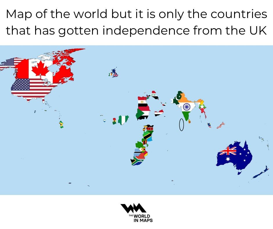
What do you think?


John Tayleur says
Amazing Map! Who would have thought that a few small islands off the coast of Europe could have had such an influence?
I live in the Channel Islands; as part of Normandy we like to think of England as our oldest colony.
One question – what country is the red oblong over the western English Channel marked ‘1964’?
Also, you left out the ‘United States of the Ionian Islands’, a British protectorate from 1814 to 1864.
Many thanks,
John