Why is America so fat? Well as this faux Time magazine cover created by Ricky Linn shows, it may be because the country looks like a man gorging himself on an Alaskan-sized burger.
Making Sense Of The World, One Map At A Time
Last Updated: 1 Comment

Why is America so fat? Well as this faux Time magazine cover created by Ricky Linn shows, it may be because the country looks like a man gorging himself on an Alaskan-sized burger.
Last Updated: Leave a Comment
As difficult as it may be to believe, the The Nineteenth Amendment to the United States Constitution was ratified on August 18th, 1920, less than 100 years ago. It stated that: “The right of citizens of the United States to vote shall not be denied or abridged by the United States or by any State on account of sex.” In plain English, it gave the vote to all women of voting age.
However, before its passage, not all women had been denied the vote as the map above demonstrates.
[Read more…]
Last Updated: 12 Comments
The map above shows where schools close for Jewish Holidays. Reddit user jonross14 explains more about how he created the map:
My wife and I created this map. A colored county means that at least one school countywide closes for Jewish Holidays, not necessarily all schools in the county. We also designated a county if they only closed for one Jewish holiday, for example Yom Kippur but not Rosh Hashanah, or if a district consistently gives a PD (teachers-only) day on a Jewish holiday. TL;DR if any district in a county closes school to students for any Jewish holiday they are included in this map. Enjoy!
If, like me, you’re not familiar with the major Jewish holidays they are:
Last Updated: 2 Comments

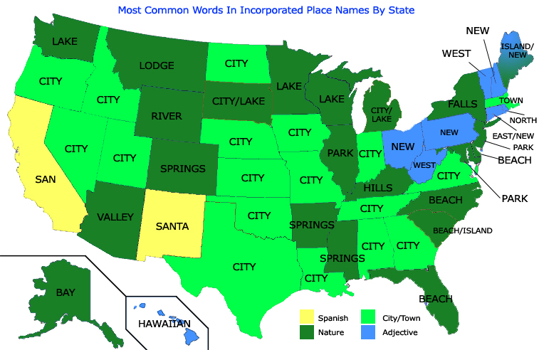
Ever wonder what word most commonly appears in your State’s place names? Me neither, nevertheless the map above is really interesting. The overwhelming majority of states have the rather unoriginal ‘city’ as the most common word.
Last Updated: 3 Comments
The US is the third most populous country on earth, with over 320 million people according the current U.S. Census Population Clock. Yet, only around 4.4% of the world’s people live in the country and considering it’s only the 180th most densely populated country on earth, it’s rather sparsely populated.
Moreover, if the US ever wanted to catch-up with China (most populated) or India (soon to be most populated), it would have to increase its population fourfold (1.2 billion+). Even then, this would still only make it the 89th most densely populated country on earth (assuming of course no population changes in any other country).
However, all this can be rather difficult to visualize. Wouldn’t it be easier to just see how the current US population fits into the rest of the world? Well the clever users of reddit have done just that. They’ve created all the maps on this page that help show how large (or not) America’s population really is.
Last Updated: 6 Comments
The United States has a population that is nearly five times greater than the United Kingdom. Yet, the UK still has more people than the 27 least populated states combined. On the other hand, the UK has fewer people than the two most populous states.
The map above shows how each of these combinations would look. In red, you can see that the UK has more people than the following states combined: