Brilliant Maps

Making Sense Of The World, One Map At A Time

  • BOOK!
  • Newsletter
  • Games & Quizes
  • Map Based Polls
  • Map Tools

Does Your State Have More Jews or Muslims?

Last Updated: January 21, 2026 3 Comments

Click To Get My 10 Best Brilliant Maps For Free:

Does Your State Have More Jews or Muslims?

The map above shows which states have more Jews than Muslims living in them and vice versa.

But, it should be noted that in absolute terms New York state has the most Jews and the most Muslims living there.

In total, 7.7 million Jews live in the United States (more than in Israel) compared to just 4.5 million Muslims (slightly less than in Palestine).

Below are the numbers for each state, the % of the state population that is Jewish or Muslim as well as the difference in numbers.
[Read more…]

Filed Under: United States

US Annual Precipitation vs Rain In London & The UK

Last Updated: November 12, 2025 1 Comment

Click To Get My 10 Best Brilliant Maps For Free:

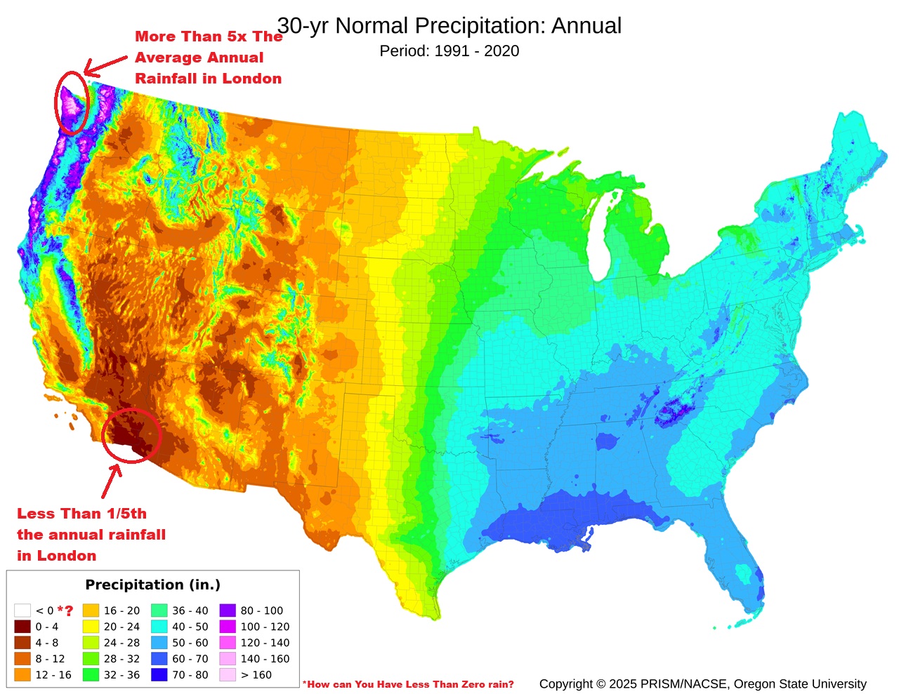
US Annual Precipitation vs Rain In London

Map credit PRISM Weather Data
The map above shows average annual precipitation in the United States over a 30-year period (1991–2020), produced by PRISM Climate Group at Oregon State University.

It shows long-term “normal” precipitation totals, measured in inches per year.

More about it:

[Read more…]

Filed Under: United States

Oklahoma Panhandle History

Last Updated: April 22, 2026 2 Comments

Click To Get My 10 Best Brilliant Maps For Free:

ok panhandle

The map above shows the location of Oklahoma which at one point was part of the Republic of Texas, before Texas joined the United States in 1845.

The story of the Oklahoma Panhandle, that narrow, rectangular strip of land at the state’s far west, is one of the quirkiest tales in American geography.

Its evolution from being part of Texas, to becoming “No Man’s Land,” and finally part of Oklahoma involves a mix of statehood law, slavery politics, and settlement patterns.

Here’s how it happened:

[Read more…]

Filed Under: United States

Where is Kansas City & Why Are There Two Of Them?

Last Updated: August 12, 2026 2 Comments

Click To Get My 10 Best Brilliant Maps For Free:

Where is Kansas City?

Map grid from @FerusdeGeo
In the map above Kansas City is in grid B3, although there in fact two Kansas cities located there.

See this map:

Kansas City Location Map

Here’s the story behind the two Kansas Cities: one in Kansas and the bigger, older one in Missouri:

[Read more…]

Filed Under: United States

Share Of Households Participating in SNAP (Food Stamps) By U.S. Congressional House District

Last Updated: October 28, 2025 Leave a Comment

Click To Get My 10 Best Brilliant Maps For Free:

Map Showing Share Of Households Participating in SNAP By U.S. Congressional House District

Map found here

The map above shows the share of households in a given congressional district that receive SNAP (aka food stamps) payments. The data comes from the USDA for 2023 here and here it is below:

[Read more…]

Filed Under: United States

All The Countries That Have Militarily Defeated The United States (With Explanations)

Last Updated: April 22, 2026 11 Comments

Click To Get My 10 Best Brilliant Maps For Free:

All The Countries That Have Militarily Defeated The United States (With Explanations)

The map above shows which countries the US has lost wars or other military conflicts to. However, defining what is a loss is very tricky.

[Read more…]

Filed Under: United States, World Maps

The Radial States of America

Last Updated: October 3, 2025 Leave a Comment

Click To Get My 10 Best Brilliant Maps For Free:

The Radial States of America

Map created by Mapsburgh

The map above shows what the US might look like if it all 50 states radiated out from the centre of the country. From the map author:

[Read more…]

Filed Under: United States

Manhattan Today Has 600k Fewer People Living On It Than It Did In 1910

Last Updated: September 30, 2025 Leave a Comment

Click To Get My 10 Best Brilliant Maps For Free:

Manhattan Today Has 600k Fewer People Living On It Than It Did In 1910

Map created by Brandon Fuller
The map today shows a rather surprising fact.

Manhattan today has over 600,000 fewer people living on it than it did before the advent of the majority of the skyscrapers that define its iconic skyline today.

[Read more…]

Filed Under: United States

Brilliant Transit Style Map of North American Rivers

Last Updated: September 24, 2026 Leave a Comment

Click To Get My 10 Best Brilliant Maps For Free:

Brilliant Transit Style Map of North American Rivers

Map created by Daniel Huffman
The map above is a very cool reimagining of North American rivers as a Tube style map. From the author:

[Read more…]

Filed Under: United States

Could Terrible Maps Brilliantly Awful Two State Solution Map Work?

Last Updated: September 22, 2025 2 Comments

Click To Get My 10 Best Brilliant Maps For Free:

Terrible Maps, Brilliantly Awful Two State Solution Map

Credit Terrible Maps
The map above has gone mega viral as not very serious proposed two state solution for the United States.

It obviously draws the idea of a proposed Israeli-Palestinian two state solutions such as Trump’s Peace Plan For Israel & Palestine, which would have included a West Bank to Gaza Tunnel linking the two territories together. And on the overall level of political division within America.

But would it work?

Below I give my not terribly serious answer.

[Read more…]

Filed Under: United States

  • « Previous Page
  • 1
  • …
  • 4
  • 5
  • 6
  • 7
  • 8
  • …
  • 30
  • Next Page »


Product Reviews · World Atlas · Map Posters · Settlers of Catan · Risk · Game of Thrones · Coloring Books · Globes · Monopoly · Star Wars · Game of Life · Pandemic · Ticket To Ride · Drinks Cabinets
Size Comparisons · US Locations · Flight Maps · Fleet Management
Copyright © 2026 · Privacy Policy · Fair Use, Attribution & Copyright · Contact Us
Follow Us: Newsletter · Facebook · Youtube · Twitter · Threads · BlueSky · LinkedIn · Instagram · Pinterest · Flipboard