Brilliant Maps

Making Sense Of The World, One Map At A Time

  • BOOK!
  • Newsletter
  • Board Games
  • Posters
  • Scratch Maps

Travel Time from Ancient Rome

Last Updated: March 3, 2023 1 Comment

Click To Get My 10 Best Brilliant Maps For Free:

Travel Time from Ancient Rome

Map created by Stanford University’s ORBIS project

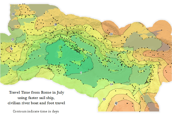
The map above is an Isochrone map which shows how long it would have taken someone to travel from Rome to the farthest reaches of the Roman Empire at its peak (roughly 200 CE/AD).

Travelling within the core of the Empire could have be done in under a week, but travelling all the way to the fringes would have taken someone more than a month.

Contrast that with Travel Times From London in 2016 vs 1914. By 1914 you could have reached almost any point on earth within 40 days and by 2016 you could reach almost any point on earth within 2 days.

If you’re curious about the project, here’s a very brief introduction:

ORBIS: The Stanford Geospatial Network Model of the Roman World reconstructs the time cost and financial expense associated with a wide range of different types of travel in antiquity. The model is based on a simplified version of the giant network of cities, roads, rivers and sea lanes that framed movement across the Roman Empire. It broadly reflects conditions around 200 CE but also covers a few sites and roads created in late antiquity.

The model consists of 632 sites, most of them urban settlements but also including important promontories and mountain passes, and covers close to 10 million square kilometers (~4 million square miles) of terrestrial and maritime space. 301 sites serve as sea ports. The baseline road network encompasses 84,631 kilometers (52,587 miles) of road or desert tracks, complemented by 28,272 kilometers (17,567 miles) of navigable rivers and canals.

You can learn more about the project and play with an interactive version on the ORBIS homepage.

For other maps of the Roman Empire have a look at:

  • An Incredibly Detailed Map of the Roman Empire At Its Height in 211AD
  • Roman Empire GDP Per Capita Map
  • Roman City of Londinium Around AD 200
  • A View Of Roman Carthage, Built on the Site of the Previously Destroyed Punic Capital
  • Byzantine Constantinople Before It Was Istanbul
  • Byzantine Empire’s Linguistic Divisions Under Justinian I c.560CE

And to learn even more about the Roman world have a look at:

  • SPQR: A History of Ancient Rome
  • Ancient Rome. The Rise And Fall Of An Empire
  • Pax Romana: War, Peace and Conquest in the Roman World

Filed Under: Europe, History Tagged With: rome

Click To Get My 10 Best Brilliant Maps For Free:


Other Popular Maps

  • Kazakhstan Was The Last Soviet Republic To Leave The USSR (4 Days After Russia), Which Means That For 4 Days, This Was The Map Of The Soviet Union

    Kazakhstan Was The Last Soviet Republic To Leave The USSR (4 Days After Russia), Which Means That For 4 Days, This Was The Map Of The Soviet Union

  • Differences In The Actual (25¢) & Proposed (40¢) Inflation Adjusted Original Minimum Wage By State Between 1938 & 2024

    Differences In The Actual (25¢) & Proposed (40¢) Inflation Adjusted Original Minimum Wage By State Between 1938 & 2024

  • Game of Thrones’ Westeros Is Really Just Britain & An Inverted Ireland

    Game of Thrones’ Westeros Is Really Just Britain & An Inverted Ireland

  • Map of The Most Common Type of Home in Europe

    Map of The Most Common Type of Home in Europe

  • Just The World’s Time Zones

    Just The World’s Time Zones

  • Yemen vs Oman

    Yemen vs Oman

  • European Countries With A Population Less Than The Moscow Metropolitan Area

    European Countries With A Population Less Than The Moscow Metropolitan Area

  • Countries That Qualified For The 2010, 2014 & 2018 FIFA World Cups

    Countries That Qualified For The 2010, 2014 & 2018 FIFA World Cups

Comments

  1. François says

    November 2, 2025 at 6:17 pm

    “Contours indicate time in days” → I guess it’s “weeks”! 😉

    Reply

Leave a Reply Cancel reply

Your email address will not be published. Required fields are marked *

This site uses Akismet to reduce spam. Learn how your comment data is processed.


Product Reviews · World Atlas · Settlers of Catan · Risk · Game of Thrones · Coloring Books
Globes · Monopoly · Star Wars · Game of Life · Pandemic · Ticket To Ride · Drinks Cabinets
US Locations · UK Locations· Fleet Management
Copyright © 2026 · Privacy Policy · Fair Use, Attribution & Copyright · Contact Us
Follow Us: Newsletter · Facebook · Youtube · Twitter · Threads · BlueSky · LinkedIn · Instagram · Pinterest · Flipboard