Brilliant Maps

Making Sense Of The World, One Map At A Time

  • BOOK!
  • Newsletter
  • Board Games
  • Posters
  • Scratch Maps

The Known World According To Herodotus In The 5th Century BC

Last Updated: September 26, 2024 3 Comments

Click To Get My 10 Best Brilliant Maps For Free:

The Known World According To Herodotus In The 5th Century BC

Map crated by Bibi Saint-Pol via Wikimedia

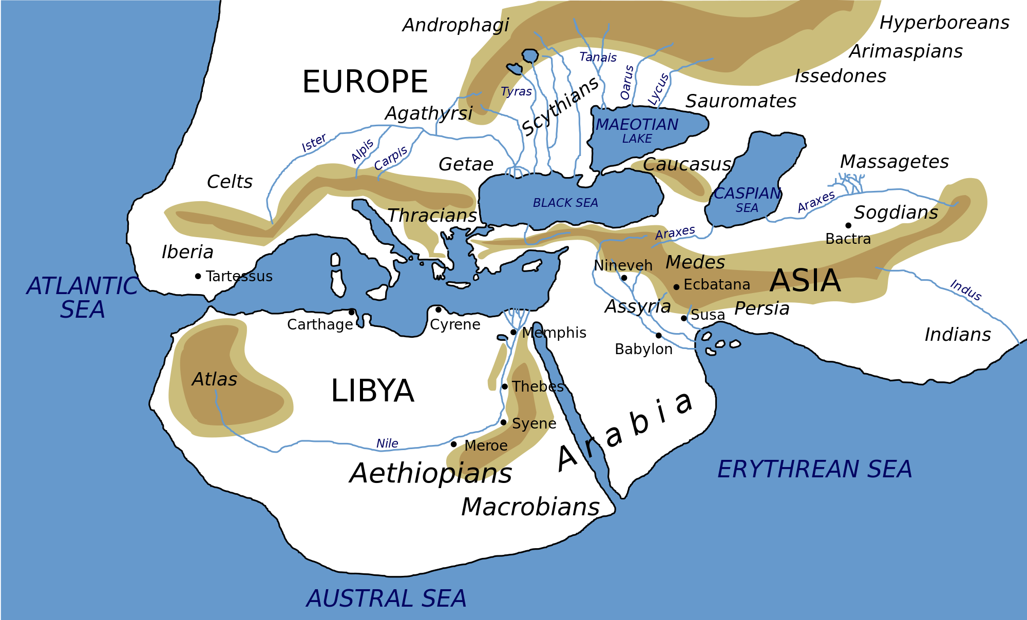
The map above is a modern depiction of ancient Greek historian Herodotus’ view of the Ecumene (or oecumene), literally the the known or the inhabited world, in the 5th Century BC.

And while obviously far from fully accurate it clearly shows Europe, Africa and Asia.

[Read more…]

Filed Under: World Maps

Cryptids By State: The Most Famous Mythical Creatures & Animals In Each US State

Last Updated: September 3, 2024 16 Comments

Click To Get My 10 Best Brilliant Maps For Free:

The Most Famous Mythical Creatures & Animals In Each US State

Map created by CashNetUSA
The map above shows the most famous mythical creature or animal in each US state. It was created as a new bestiary, literally a compendium of beasts, for the the United States.

Here is a list of mythical creature by state:

[Read more…]

Filed Under: United States

Building The World Country By Country In Order of Population Density [Lowest to Highest]

Last Updated: March 10, 2025 1 Comment

Click To Get My 10 Best Brilliant Maps For Free:

Map created by Engaging Data using Leaflet

The map above shows the world being build one country at time starting with Greenland (0.03 people per square KM) all the way to up to Bangladesh (1,251 people per square KM). And while, it’s really neat it’s not 100% complete.

[Read more…]

Filed Under: World Maps

Percent Of Voters By State Who Didn’t Vote For Hillary or Trump In 2016

Last Updated: March 3, 2023 1 Comment

Click To Get My 10 Best Brilliant Maps For Free:

not hillary trump

Map created by reddit user ChemAnon2018

The map above shows the percentage of voters in each state who voted in the 2016 presidential election but didn’t vote for either Hillary or Trump.

[Read more…]

Filed Under: United States

Global Warming at Different Latitudes By Year Vs 1961-90 Average

Last Updated: March 3, 2023 3 Comments

Click To Get My 10 Best Brilliant Maps For Free:

Global Warming at Different Latitudes

Map created by reddit user neilrkaye

The map above shows the range of global temperatures at different latitudes in 11 year windows starting in 1948-1958 ending in 2008-2018.

Anything to the left of the black line is cooler than the 1961-1990 average at that latitude and anything to the right is warmer.

[Read more…]

Filed Under: World Maps

The British Empire At Its Territorial Peak Covered Nearly The Same Area As The Moon

Last Updated: March 3, 2023 5 Comments

Click To Get My 10 Best Brilliant Maps For Free:

The British Empire at its territorial peak covered nearly the same area as the Moon

Map created by reddit user jmerlinb; @jackmerlinbruce

The illustration above shows just how big the British Empire was at its territorial peak in the early 1920s. At that time it covered 35.5 million sq km (13.71 million sq mi), which represents 23.84% of the Earth’s land area or equivalent to 93.67% of the Moon’s surface area (37.9 million sq km).

[Read more…]

Filed Under: Other

Is This The World’s Longest Continuous Walk? Cape Town To Magadan

Last Updated: June 17, 2024 65 Comments

Click To Get My 10 Best Brilliant Maps For Free:

Is This The World's Longest Continuous Walk? Cape Town To Magadan

Map created using Google Maps

The map above potentially shows one of the world’s longest uninterrupted walks from Cape Town, South Africa to Magadan, Russia a distance of 22,387km (13,910 miles).

[Read more…]

Filed Under: World Maps

Map of World War 2 Shipwrecks

Last Updated: January 14, 2025 10 Comments

Click To Get My 10 Best Brilliant Maps For Free:

Map of World War 2 Shipwrecks

Map created by Rean Monfils
The map above shows many (but not all of) of the ships sunk during World War 2. The map was created by Rean Monfils and combines the Geographic Information System (GIS) database of Asian Pacific shipwrecks with the Atlantic, Mediterranean and Indian Ocean (AMIO) WWII shipwreck database.

[Read more…]

Filed Under: World Maps

1988 East German Map of West Berlin

Last Updated: March 3, 2023 7 Comments

Click To Get My 10 Best Brilliant Maps For Free:

1988 East German Map of West Berlin

Map found at HERE 360

The map above is one of our favourites. It shows (or rather doesn’t show) West Berlin in 1988. It was published in East Germany just one year before the fall of the Berlin Wall.

[Read more…]

Filed Under: Germany, History

Map Projections: Mercator Vs The True Size of Each Country

Last Updated: October 28, 2025 17 Comments

Click To Get My 10 Best Brilliant Maps For Free:

Mercator Vs True Size of Each Country

Map found via reddit, click for larger version
While it’s well known that the mercator projection distorts the world, the maps here show very clearly by how much. Countries close to the equator barely change, whereas countries further north shrink dramatically.

The maps are all the work of climate data scientist @neilrkaye.

You can see an animation below:

[Read more…]

Filed Under: World Maps

  • « Previous Page
  • 1
  • …
  • 115
  • 116
  • 117
  • 118
  • 119
  • …
  • 151
  • Next Page »


Product Reviews · World Atlas · Settlers of Catan · Risk · Game of Thrones · Coloring Books
Globes · Monopoly · Star Wars · Game of Life · Pandemic · Ticket To Ride · Drinks Cabinets
US Locations · UK Locations· Fleet Management
Copyright © 2026 · Privacy Policy · Fair Use, Attribution & Copyright · Contact Us
Follow Us: Newsletter · Facebook · Youtube · Twitter · Threads · BlueSky · LinkedIn · Instagram · Pinterest · Flipboard