
The D-Day landings themselves were codenamed Operation Neptune and remain the largest seaborne invasion in history. This was part of the broader Operation Overlord to defeat the Nazis.
Nearly 160,000 troops crossed the English Channel on June 6th. And by the end of August over two million Allied troops were in France.
More maps and an explanation below:
The Atlantic Wall made any invasion of mainland Europe from the UK difficult as the map below shows:

What was the Atlantic Wall?
The Atlantic Wall was an extensive system of coastal defenses and fortifications built by Nazi Germany between 1942 and 1944 along the western coast of Europe.
It stretched from the northern tip of Norway down to the border of Spain, covering the coasts of countries such as France, Belgium, the Netherlands, Denmark, and Norway.
The primary purpose of the Atlantic Wall was to deter and defend against an anticipated Allied invasion of mainland Europe.
Key Features of the Atlantic Wall:
- Bunkers and Fortifications: The wall consisted of thousands of concrete bunkers, gun emplacements, and pillboxes designed to house artillery, machine guns, and troops.
- Obstacles and Mines: Extensive use of beach obstacles, barbed wire, anti-tank barriers, and millions of mines were laid to impede any amphibious landings.
- Heavy Artillery: Many of the fortifications were equipped with heavy artillery capable of firing on ships and landing craft from considerable distances.
- Strategic Locations: Key ports, estuaries, and strategic points were heavily fortified, including places like the Pas-de-Calais, which the Germans believed to be a likely invasion point.
- Radar and Surveillance: The defenses included radar stations to detect incoming Allied ships and aircraft.
Historical Context:
- Construction: Construction began in 1942 under the supervision of Field Marshal Erwin Rommel, who was appointed to oversee the fortifications. The work involved forced labor from occupied countries as well as German military engineers.
- Normandy Invasion: Despite its extensive defenses, the Atlantic Wall was breached during the Allied invasion on D-Day, June 6, 1944. The Normandy beaches, particularly Omaha Beach, saw intense fighting, but the Allies were able to establish a beachhead and eventually break through the defenses.
- Impact: The Atlantic Wall, while formidable, was not impenetrable. Its effectiveness was hampered by several factors, including the sheer length of coastline to be defended, the strategic deception by the Allies (Operation Fortitude), and the overwhelming air and naval superiority of the Allied forces.
Why did the allies chose invade France rather than continue the invasion from Italy?
The Allies chose to invade France rather than continue the primary invasion effort through Italy for several strategic reasons:
- Direct Route to Germany: Invading France provided a more direct route to Germany’s industrial heartland. France’s northern coast was much closer to Germany than Italy, facilitating a quicker and more efficient advance towards the ultimate goal of defeating Nazi Germany.
- Opening a Second Front: The Soviet Union had been urging the Western Allies to open a second front in Western Europe to alleviate the immense pressure on the Soviet forces fighting on the Eastern Front. An invasion of France would force Germany to divert significant resources and troops from the Eastern Front to defend against the new Western threat.
- Terrain and Logistical Considerations: The terrain in northern France was more suitable for large-scale mechanized warfare than the rugged and mountainous terrain of Italy. France’s landscape was better suited for the rapid movement and supply of large Allied forces, facilitating faster and more effective operations.
- Ports and Supply Lines: Northern France offered several major ports (such as Cherbourg and Le Havre) that were essential for the Allies to supply their invading forces. Securing these ports would ensure a steady flow of troops, equipment, and supplies necessary for sustaining the invasion and subsequent operations.
- Strategic Surprise and Deception: The Germans expected the main Allied invasion to come through the Pas-de-Calais, the shortest crossing point from Britain to France. By choosing Normandy instead, the Allies achieved strategic surprise, as the Germans were not fully prepared for an invasion in that region.
- Supporting the Resistance: Invading France would provide direct support to the French Resistance, which was already active in sabotaging German operations and gathering intelligence. This internal resistance would complement the Allied invasion efforts.
- Limitations of the Italian Campaign: While the Allies had already invaded Italy and made significant progress, the campaign there had become bogged down due to the challenging terrain and strong German defensive positions. The mountainous terrain and fortified lines, such as the Gustav Line, made further advances slow and costly.
- Political Considerations: Liberating France held significant political and symbolic importance. France was a major Allied nation that had been under German occupation since 1940, and its liberation was crucial for the restoration of its sovereignty and morale.
When did the planning for D-Day begin?
Planning for D-Day began well before the actual invasion on June 6, 1944.
The groundwork for this massive military operation involved several stages and key events:
- Initial Concepts and Agreements (1942-1943):
- Casablanca Conference (January 1943): Allied leaders, including U.S. President Franklin D. Roosevelt and British Prime Minister Winston Churchill, discussed the idea of a cross-Channel invasion. The decision to prioritize this operation was made here.
- Trident Conference (May 1943): Further discussions took place regarding the specifics of the invasion, including timing and coordination with other military efforts, such as the Italian Campaign.
- Formation of the Planning Staff (Early 1943):
- The Chief of Staff to the Supreme Allied Commander (COSSAC), initially headed by British Lieutenant General Frederick E. Morgan, was tasked with creating an initial plan for the invasion. Morgan and his team started developing detailed plans and considering logistics, landing sites, and operational goals.
- Tehran Conference (November-December 1943):
- At this conference, attended by Roosevelt, Churchill, and Soviet Premier Joseph Stalin, the Allies solidified their commitment to launching the invasion in the spring of 1944. This agreement ensured that the Western Allies would open a second front to relieve pressure on Soviet forces on the Eastern Front.
- Operation Overlord Plan (January 1944):
- The final, detailed plan for Operation Overlord was developed and approved. General Dwight D. Eisenhower was appointed as the Supreme Allied Commander in December 1943 and took charge of the final preparations for the invasion.
- Intensive Planning and Rehearsals (Early 1944):
- Detailed planning included selecting Normandy as the landing site, organizing the logistics of transporting hundreds of thousands of troops and equipment, and coordinating air and naval support.
- Extensive deception operations, including Operation Fortitude, were implemented to mislead the Germans about the true landing site.
- Training and rehearsal exercises, such as Exercise Tiger, were conducted to prepare the troops for the actual landings.
Timeline Summary:
- Early 1943: Initial planning and formation of COSSAC.
- Mid-1943: Detailed planning and selection of Normandy.
- Late 1943: Tehran Conference confirms commitment to the invasion.
- Early 1944: Finalization of the Operation Overlord plan and appointment of Eisenhower.
- Spring 1944: Intensive rehearsals and deception operations.
The map below shows the Allied Invasion force:

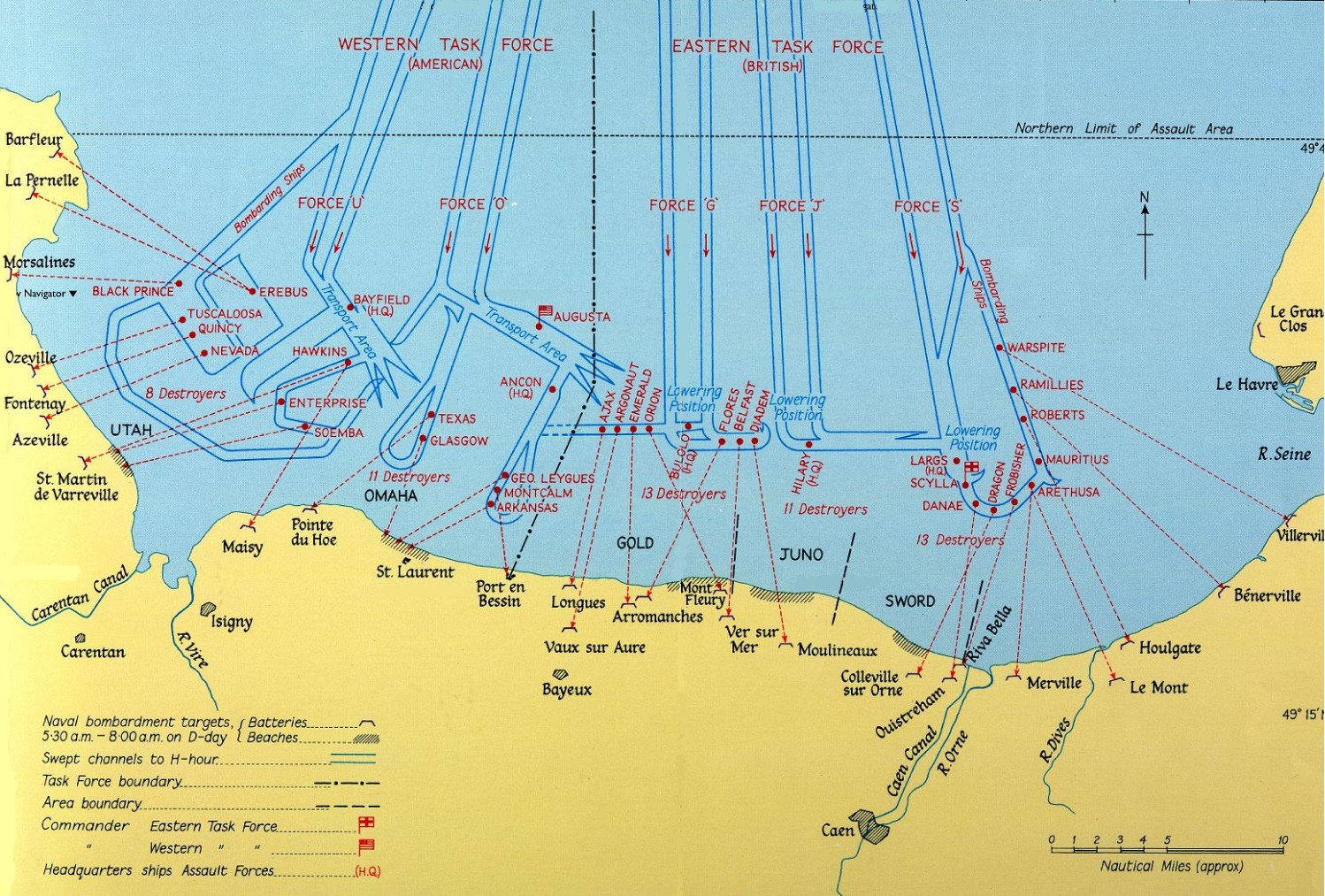
And this map shows the Naval Bombardments on D-Day:
Timeline of Events on D-Day (June 6, 1944)
Pre-dawn hours:
- 00:00 – 02:00: Paratroopers from the American 82nd and 101st Airborne Divisions and the British 6th Airborne Division begin landing behind enemy lines to secure key bridges and roads. About 24,000 paratroopers were involved in these operations.
Early morning:
- 03:00 – 04:00: Allied bombers and naval bombardment commence targeting German defenses along the coast.
- 04:30: British glider troops capture Pegasus Bridge, an essential objective for the British 6th Airborne Division.
The Beaches:
- Utah Beach (American)
- 06:30: First wave of American troops land. By the end of the day, around 23,000 troops had landed.
- Casualties: Approximately 197 killed, wounded, or missing.
- Progress: Secured beachhead and pushed inland 4 miles.
- Omaha Beach (American)
- 06:30: Landings begin. This beach saw the heaviest resistance and casualties.
- Casualties: About 2,000-2,500 killed, wounded, or missing.
- Progress: Slow and difficult advances, but by the end of the day, a beachhead was established.
- Gold Beach (British)
- 07:25: British 50th Infantry Division lands.
- Casualties: Around 1,000 killed, wounded, or missing.
- Progress: Secured beachhead and linked with Juno Beach forces.
- Juno Beach (Canadian)
- 07:35: Canadian 3rd Infantry Division lands.
- Casualties: Approximately 1,200 killed, wounded, or missing.
- Progress: Secured beachhead and linked with Gold Beach forces.
- Sword Beach (British)
- 07:25: British 3rd Infantry Division lands.
- Casualties: Around 630 killed, wounded, or missing.
- Progress: Secured beachhead and linked with airborne forces inland.
Allied Forces Involved:
- Total Allied troops landed on D-Day: Approximately 156,000.
- American: Around 73,000 (23,000 at Utah Beach and 50,000 at Omaha Beach).
- British: Around 61,715 (24,970 at Gold Beach and 28,845 at Sword Beach, plus airborne troops).
- Canadian: About 21,400 at Juno Beach.
Airborne Landings:
- British and American paratroopers played a crucial role in securing the flanks of the landing beaches and disrupting German reinforcements.
End of Day Progress:
- Utah Beach: Secured beachhead, 4 miles inland.
- Omaha Beach: Established a tenuous beachhead, advancing less than a mile in some areas.
- Gold Beach: Linked with Juno Beach forces, several miles inland.
- Juno Beach: Linked with Gold Beach forces, several miles inland.
- Sword Beach: Linked with airborne forces, several miles inland.
Casualties:
- Allied casualties: Estimates range between 4,000 to 10,000+ killed, wounded, or missing. 4,414 confirmed dead.
- German casualties: Estimates are more varied, between 4,000 to 9,000 killed, wounded, or missing.
The final map below is an Official U.S. 12th Army position map at 2400 on D-Day:

You can also watch the whole day in 60 seconds below:
Was D-day a Success?
D-Day was considered a success for several reasons, despite the heavy casualties and challenges faced during the operation. Here are the key factors that contributed to its success:
Objectives Achieved
- Establishing a Beachhead: The primary objective of D-Day was to establish a secure beachhead in Normandy from which further operations could be launched. By the end of June 6, 1944, the Allies had secured all five beaches (Utah, Omaha, Gold, Juno, and Sword) and had begun moving inland.
- Opening a Western Front: The successful landings on D-Day opened a new Western Front in Europe, forcing Germany to fight a two-front war. This significantly relieved pressure on the Soviet forces fighting on the Eastern Front.
- Securing Key Locations: Airborne and amphibious forces secured crucial points behind enemy lines, such as bridges and roadways, which facilitated the movement of troops and supplies inland.
Strategic Impact
- Resource and Troop Diversion: The invasion forced Germany to divert significant resources and troops from the Eastern Front and other areas to defend against the Allied advance in France.
- Boosting Morale: The success of D-Day provided a significant morale boost to the Allied forces and the occupied nations in Europe. It demonstrated the possibility of liberating Western Europe from Nazi control.
- Supporting Resistance Movements: The invasion supported and invigorated local resistance movements in France and other occupied countries, further disrupting German operations and logistics.
Operational Success
- Coordination and Planning: The meticulous planning and coordination of naval, air, and ground forces contributed to the overall success of the operation. Deception operations like Operation Fortitude successfully misled the Germans about the invasion location.
- Logistical Achievements: The Allies managed to land and supply a massive number of troops, vehicles, and equipment on the beaches of Normandy.
Challenges and Casualties
- Heavy Casualties: While D-Day was successful, it came at a high cost. Allied forces suffered significant casualties, particularly at Omaha Beach, where resistance was fierce.
- German Response: The Germans were initially caught off guard, but they quickly mobilized their defenses. However, the overwhelming numbers and superior coordination of the Allied forces eventually overcame the German resistance.
Long-Term Outcomes
- Liberation of France: Following D-Day, Allied forces continued to push inland, leading to the liberation of Paris in August 1944 and eventually the rest of France.
- Path to Victory in Europe: The successful invasion of Normandy was a critical step toward the ultimate defeat of Nazi Germany. It paved the way for further Allied advances into Belgium, the Netherlands, and Germany.
Watch the invasion and everything that followed in 60 seconds:
Or the full version with narration and explanations:
Surprising Facts About D-Day:
Here are 20 surprising facts about D-Day:
- Largest Amphibious Invasion: D-Day, known as Operation Overlord, was the largest amphibious invasion in history, involving over 156,000 troops, 11,000 aircraft, and 5,000 vessels.
- Operation Fortitude: The Allies conducted an extensive deception operation called Operation Fortitude to mislead the Germans about the invasion location, making them believe the main attack would occur at Pas-de-Calais.
- Tide and Moon Considerations: The timing of D-Day was carefully chosen based on tide and moon conditions, aiming for a full moon and low tide to expose German beach defenses.
- Artificial Harbors: The Allies built two massive artificial harbors called Mulberries to facilitate the rapid unloading of supplies. One was destroyed by a storm shortly after D-Day, but the other remained in use.
- Pluto Pipeline: The Allies laid a pipeline under the English Channel, known as PLUTO (Pipeline Under The Ocean), to supply fuel to the invading forces.
- Ruperts and Paratrooper Dummies: Fake paratroopers, called “Ruperts,” were dropped to create confusion and divert German forces away from the actual landing zones.
- Secret Weather Forecast: The invasion was initially planned for June 5 but was delayed due to bad weather. A brief window of improved weather on June 6 allowed the invasion to proceed.
- Rommel’s Absence: Field Marshal Erwin Rommel, in charge of defending the Atlantic Wall, was away in Germany celebrating his wife’s birthday when the invasion began.
- Coded Messages in Radio Broadcasts: The BBC broadcast pre-arranged coded messages to inform the French Resistance about the timing of the invasion.
- Hobart’s Funnies: The British developed specialized tanks called “Hobart’s Funnies,” including amphibious tanks, mine-clearing tanks, and bridge-laying tanks, to overcome beach defenses.
- Double Agents: The Allies used double agents, such as the Spanish spy Garbo, to feed false information to the Germans about the invasion plans.
- Civilian Casualties: Approximately 15,000-20,000 French civilians were killed during the D-Day invasion and subsequent Battle of Normandy due to bombings and combat operations.
- Medal of Honor: Theodore Roosevelt Jr., the son of former U.S. President Theodore Roosevelt, was the only general to land with the first wave of troops. He received the Medal of Honor for his bravery.
- Captured Soldiers: Some of the German soldiers captured by the Allies on D-Day were actually from the Soviet Union. These men had been conscripted into the German army after being captured by the Germans.
- First American Cemetery: The Normandy American Cemetery and Memorial at Colleville-sur-Mer was the first American cemetery on European soil in World War II.
- Mislandings: Many paratroopers landed miles from their intended drop zones due to heavy anti-aircraft fire and poor visibility, but they still managed to disrupt German defenses.
- First Army Division Patch: The U.S. 1st Infantry Division, known as “The Big Red One,” which played a significant role on Omaha Beach, was the only division to have its patch approved by the Army during World War II.
- Naval Bombardment: Over 2,700 Allied ships and boats were involved in the naval bombardment of German defenses prior to the landings.
- Canadian Juno Beach: Canadian forces at Juno Beach achieved their objectives more quickly than the British and Americans, advancing further inland by the end of the day.
- Churchill’s Wish: British Prime Minister Winston Churchill wanted to accompany the invading forces and witness the landings firsthand but was dissuaded by King George VI, who insisted that Churchill’s place was in England.
Enjoy these maps? Please leave your comments below:


Leave a Reply