Brilliant Maps

Making Sense Of The World, One Map At A Time

  • BOOK!
  • Newsletter
  • Board Games
  • Posters
  • Scratch Maps

Lufthansa Group’s Airlines Have Accidentally Rebuilt The Holy Roman Empire

Last Updated: January 28, 2025 3 Comments

Click To Get My 10 Best Brilliant Maps For Free:

Lufthansa Group's Airlines Have Accidentally Rebuilt The Holy Roman Empire

Map created by reddit user marten_EU_BR

The map above shows the location of Lufthansa Group’s Airlines.

And surprisingly they’ve more or less accidentally recreated a map of the Holy Roman Empire (see below):

Map of The Holy Roman Empire At Its Territorial Peak In The 12th Century

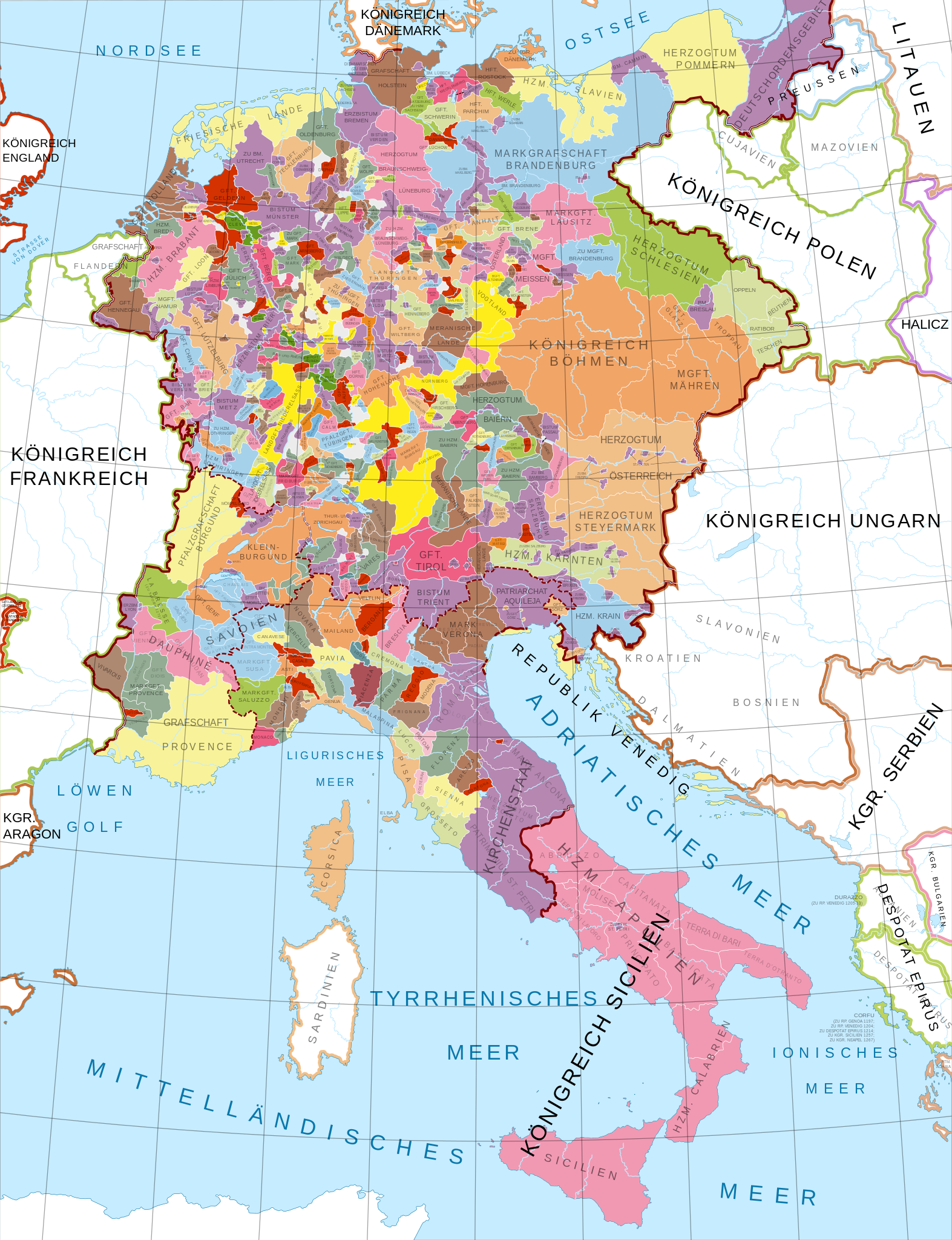
The group currently runs:

  • Lufthansa (German)
  • Austrian Airlines (Austria)
  • Brussels Airlines (Belgium)
  • Discover Airlines (Germany)
  • Eurowings (Germnay)
  • ITA Airways (Italy)
  • Swiss International Air Lines (Switzerland)

And as reddit user Archaeogrrrl points out:

Which is even more hysterical cause I’m fairly sure the name comes from Luft (air) and Hansa which refers to the Hanseatic League, a medieval trading guild. So ya know, as all about transporting goods through the insane political makeup of medieval Germany.

And on some of the exclusion of Air Dolomiti:

Air Dolomiti is not one of the major airlines of the Lufthansa Group, because according to Lufthansa Group’s website, the airline is a regional airline that is operationally closely linked to the Lufthansa mainline (the same applies to Lufthansa City, Lufthansa Cityline and Discover, which, like the Lufthansa mainline, only operate flights to and from Frankfurt and Munich).

Edelweiss and SunExpress were also not included for similar reasons.

For more airline related maps have a look at our Airline & Airport Flight Route Maps here.

Filed Under: Europe

Click To Get My 10 Best Brilliant Maps For Free:


Other Popular Maps

  • Europe As It Should Be According To Louis P Bénézet In 1918

    Europe As It Should Be According To Louis P Bénézet In 1918

  • Political Map of 48 Hypothetical US states Centered Around The 48 Largest Urban Areas

    Political Map of 48 Hypothetical US states Centered Around The 48 Largest Urban Areas

  • Number of Cities With A Tram System in Europe

    Number of Cities With A Tram System in Europe

  • Map Of 3,554 Shipwrecks Around Ireland Going Back To 1530

    Map Of 3,554 Shipwrecks Around Ireland Going Back To 1530

  • Fertility Rate Decline By State From 2005 to 2022

    Fertility Rate Decline By State From 2005 to 2022

  • All The Bars In France That Primarily Serve Alcohol

    All The Bars In France That Primarily Serve Alcohol

  • The Use of Special Latin Characters By European Country

    The Use of Special Latin Characters By European Country

  • Stunning Elevation Maps of the World

    Stunning Elevation Maps of the World

Comments

  1. Peters says

    February 3, 2025 at 6:42 am

    Mallorca is a stronghold of eurowings. Biggest airline on the island. You should add that to the Roman Empire 😉

    Reply
  2. Matthew Lungerhausen says

    February 3, 2025 at 8:48 pm

    “Neither Holy, Nor Roman, Nor an Airline.”
    -Voltaire, maybe.

    Reply
    • Brilliant Maps says

      February 3, 2025 at 8:54 pm

      Volt-air?

      Reply

Leave a Reply Cancel reply

Your email address will not be published. Required fields are marked *

This site uses Akismet to reduce spam. Learn how your comment data is processed.


Product Reviews · World Atlas · Settlers of Catan · Risk · Game of Thrones · Coloring Books
Globes · Monopoly · Star Wars · Game of Life · Pandemic · Ticket To Ride · Drinks Cabinets
US Locations · UK Locations· Fleet Management
Copyright © 2026 · Privacy Policy · Fair Use, Attribution & Copyright · Contact Us
Follow Us: Newsletter · Facebook · Youtube · Twitter · Threads · BlueSky · LinkedIn · Instagram · Pinterest · Flipboard