
In 1973, American geographer George Etzel Pearcy proposed a significant reorganization of the United States’ state boundaries, aiming to reduce the number of states from 50 to 38.
His plan sought to address issues arising from outdated borders that no longer reflected the nation’s demographic and economic realities.
Key Aspects of Pearcy’s Proposal:
- Metropolitan Center Alignment: Pearcy advocated for state boundaries that would place major metropolitan areas centrally within each state. This approach aimed to prevent cities from being divided across multiple states, thereby simplifying governance and resource allocation. For example, his plan would have placed Chicago entirely within a new state named “Dearborn,” encompassing parts of present-day Illinois, Indiana, Wisconsin, and Michigan.
- Renaming States: Given the extensive redrawing of boundaries, Pearcy proposed new names for the states, often inspired by regional geographic features or cultural history. Examples include “Cascade” for areas in Washington and Oregon, and “Alamo” for a region in Texas.
- Economic and Political Efficiency: By reducing the number of states and realigning boundaries, Pearcy believed that governance would become more efficient. He argued that fewer states with more centralized urban centers would lead to better management of resources and infrastructure, as well as more coherent economic policies.
While Pearcy’s proposal garnered interest from some economists, geographers, and politicians, it faced significant challenges.
The logistical complexities of redrawing state lines, renaming states, and reorganizing political structures were substantial.
Additionally, the deep-rooted historical and cultural identities associated with existing states made such a transformation politically unfeasible.
Consequently, Pearcy’s plan did not advance beyond the proposal stage.
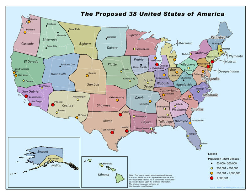
Full list of State names:
- Cascade
- Bitterroot
- El Dorado
- Bonneville
- San Luis
- San Gabriel
- Cochise
- Dakota
- Bighorn
- Platte
- Osage
- Shawnee
- Ozark
- Alamo
- Bayou
- Prairie
- Dearborn
- Mackinac
- Wabash
- Superior
- Erie
- Appalachia
- Allegheny
- Cumberland
- Carolina
- Chesapeake
- Albemarle
- Talladego
- Hudson
- Mohawk
- Susquehanna
- Kennebec
- Piedmont
- Plymouth
- Biscayne
- Kodiak
- Seward
- Kilauea
And here’s a 3rd map from Dodi Maps:

Sources:
- https://persquaremile.com/2011/11/17/redrawing-the-united-states-of-america/
- https://www.globalsecurity.org/military/world/usa/government/pearcy.htm
- https://www.mentalfloss.com/article/19364/3-controversial-maps
What do you think, good idea or not?


Allan B. says
Your compnay has SUCH great and very interesting information, but why on earth do you create the smallest maps in the world? Not everybody can afford to buy magnifying glasses.
Seriously NOT impressed.