Brilliant Maps

Making Sense Of The World, One Map At A Time

  • BOOK!
  • Newsletter
  • Board Games
  • Posters
  • Scratch Maps

12 Ways To Break The USA

Last Updated: April 10, 2025 1 Comment

Click To Get My 10 Best Brilliant Maps For Free:

12 Ways To Separate The US

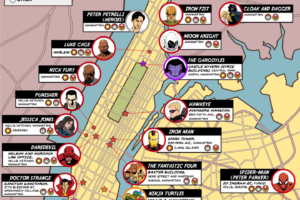
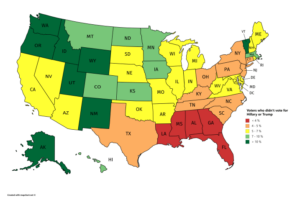
The map above is another work of Yanko Tsvetkov in his Atlas of Prejudice series.

It shows 12 different ways you can separate the US into different regions.

They are:

1

  • Hedonists
  • Square
  • Intellectuals

2

  • Microwaves
  • Barbecue Belt
  • Deep Fried South

3

  • Smarty Pants
  • Bible Belt

4

  • West Coast Hip Hop
  • Samples
  • East Coast Hip Hop

5

  • Racists in Denial
  • Heartfelt Racists

6

  • Vegans
  • Carnivores

7

  • Nasty Winters
  • Sunshine

8

  • Gays
  • People Who Will Go to Heaven

9

  • Burgers
  • Tacos
  • Fried Chicken

10

  • Caucasia
  • Mexico
  • Africa-America

11

  • Stand Your Ground
  • Stand Your Sinkhole

12

  • Land of Oz
  • Tornado Alley

What do you think?

Other maps in this series:

  • European Food According to The French
  • European Food According to Italians
  • European Food According To The Greeks
  • The Many Disgusting Dishes & Culinary Horrors of Europe
  • 20 Ways To Divide Europe By Stereotype
  • Europe According to the Vikings in 1000 AD
  • The World According To Ancient China

And you can buy his books:

  • Atlas of Prejudice: The Complete Stereotype Map Collection
  • Atlas of Prejudice: Mapping Stereotypes Volume 1 
  • Atlas of Prejudice 2: Chasing Horizons


Filed Under: United States

Click To Get My 10 Best Brilliant Maps For Free:


Other Popular Maps

  • The Blue Dot (Monaco) Has Almost 3X The GDP of The Area in Red (Greenland)

    The Blue Dot (Monaco) Has Almost 3X The GDP of The Area in Red (Greenland)

  • Prisons/Jails vs Colleges By US State

    Prisons/Jails vs Colleges By US State

  • 2025 Travel Risk Map

    2025 Travel Risk Map

  • Bird’s Eye View of The City of Ottawa, Ontario (Canada) In 1876

    Bird’s Eye View of The City of Ottawa, Ontario (Canada) In 1876

  • World Toilet Paper Map Showing Spending On Tissue & Hygiene

    World Toilet Paper Map Showing Spending On Tissue & Hygiene

  • Don’t Look At This Map If You Have A Fear Of Flying: Major Plane Crash Sites 1985-2015

    Don’t Look At This Map If You Have A Fear Of Flying: Major Plane Crash Sites 1985-2015

  • Final Map Of The Republics of the Soviet Union Published By The CIA In 1991

    Final Map Of The Republics of the Soviet Union Published By The CIA In 1991

  • Top 100 Most Sold Car Brands By European Country

    Top 100 Most Sold Car Brands By European Country

Comments

  1. Freya says

    April 25, 2025 at 5:18 pm

    Funny maps! Just one correction for the mapmaker: The opposites of vegans aren’t carnivores; they’re omnivores. A carnivore is a creature that eats *exclusively* meat. The omnivorous diet is one that includes meat but not only meat.

    Reply

Leave a Reply Cancel reply

Your email address will not be published. Required fields are marked *

This site uses Akismet to reduce spam. Learn how your comment data is processed.


Product Reviews · World Atlas · Settlers of Catan · Risk · Game of Thrones · Coloring Books
Globes · Monopoly · Star Wars · Game of Life · Pandemic · Ticket To Ride · Drinks Cabinets
US Locations · UK Locations· Fleet Management
Copyright © 2026 · Privacy Policy · Fair Use, Attribution & Copyright · Contact Us
Follow Us: Newsletter · Facebook · Youtube · Twitter · Threads · BlueSky · LinkedIn · Instagram · Pinterest · Flipboard