
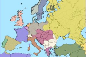
Here’s the text from the map:
NAZI WAR AIMS
Revealed by Secret Nazi Map-circulated in 1937
HERE’S THE EVIDENCE
Above is a photograph of a map issued by the Nazis in 1937. Note the hooked Sudeten Swastika, for the map was found in Czechoslovakia. See how the Germans aimed at conquering most of Europe, including Great Britain, by 1948.
Consider how this plan was being carried out.
- MARCH 1938: AUSTRIA taken —
- OCT. 1938: SUDETENLAND taken —
- MARCH 1939: CZECHOSLOVAKIA taken —
- MARCH 1939: MEMEL taken —
- SEPT. 1939: POLAND taken —
Now the policy of ‘Grab — Grab — Grab’ is at last halted.
And here’s the time presented in the map:
- Poland: by 1939
- Hungary: by 1939
- Rumania: by 1940
- Jugoslavia: by 1940
- Bulgaria: by 1940
- Ukraine: by 1941
- Denmark: by 1941
- Holland: by 1941
- Belgium: by 1941
- North France: by 1941
- Switzerland: by 1941
- Portugal: by 1948
- Great Britain: by 1948
- Scandinavia: by 1948
I came across the map while browsing: War Map: Pictorial Conflict Maps 1900-1950 at The Map House this week. And you can buy it for just £850 here.
Their description of the map is below:
This striking propaganda map offering insight into how the Allies perceived the scale of Germany’s territorial ambitions. It must have been produced after the fall of Poland in September 1939 but before the invasion of France in May 1940.
The smaller image in the upper right corner of the map purports to be a facsimile of a poster detailing Nazi Germany’s secret plans and their timetable for territorial expansion.
While the German Army High Command (Oberkommando des Heeres, of OKH) undoubtedly had contingency invasions plans for all for the countries marked on the pamphlet, it is highly unlikely that the Nazis would ever have allowed something as incendiary as this map to have been printed or disseminated.
It is more probable that it was invented by the anonymous propagandist of this work to lend credibility to his message.
While warning of the imminent threat posed by a resurgent and aggressive Germany, it is noticeable that the map’s creator have, like so many, underestimated the speed of the German attacks.
Northern France, Belgium, and Holland had all been conquered a year before the Nazis’ claimed target dates. Britain is marked for subjugation in 1948 when in fact the planned invasion “Unternehmen Seelowe” (Operation Sea Lion), was scheduled for 1940.
Soviet Russia is not marked as a target.
Germany and Russia had only just signed their non-aggression pact and it was obviously as inconceivable to this mapmaker as it was to Joseph Stalin, that Hitler could already be planning an invasion of Russia.
Enjoy this post?


Eva Sandberg says
I LOVE your maps!!! Thank you!