Brilliant Maps

Making Sense Of The World, One Map At A Time

  • BOOK!
  • Newsletter
  • Board Games
  • Posters
  • Scratch Maps

What If The US Had The Canadian Electoral System (~100k per district)

Last Updated: April 27, 2026 1 Comment

Click To Get My 10 Best Brilliant Maps For Free:

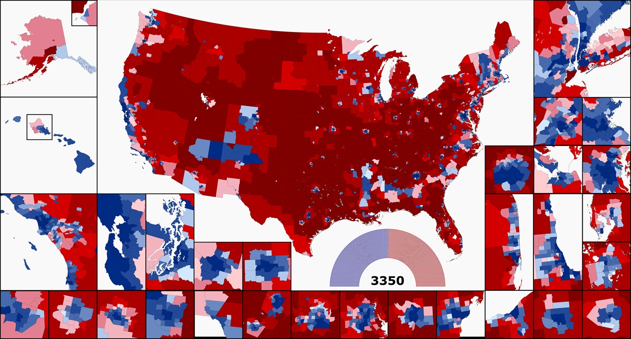
What If The US Had The Canadian Electoral System (~100k per district)

Map created by reddit user AegeanRepublic

The map above shows what the US House would look like if it had 100k people per district vs the over 750k people per district today.

Overall, you’d have a house with 3,350 members, which in this map would mean 1692 Democrats and 1658 Republicans.

About the inserst:

INSETS (if you have a hard time)

Alaska: Anchorage inset; Hawaii: Honolulu/Oahu inset (easy enough, but I put them here on a technicality)

LEFT, Third row: Los Angeles/San Diego; San Francisco Bay Area; Seattle/Puget Sound; Portland, OR; Minneapolis

RIGHT

New York City

Second row: Philadelphia (and Trenton, NJ), Boston

Third row: Atlanta, Hampton Roads, Washington DC/Baltimore

Fourth row: Miami, Chicago/Milwaukee, (top) Tampa Bay, (bottom) Orlando

BOTTOM ROW: Sacramento; Las Vegas; Phoenix; Denver; El Paso; San Antonio/Austin; Dallas/Fort Worth; Houston; St. Louis; Detroit; Cleveland; Columbus, OH; Pittsburgh

And here a few more 100k maps they’ve made:

Colorado
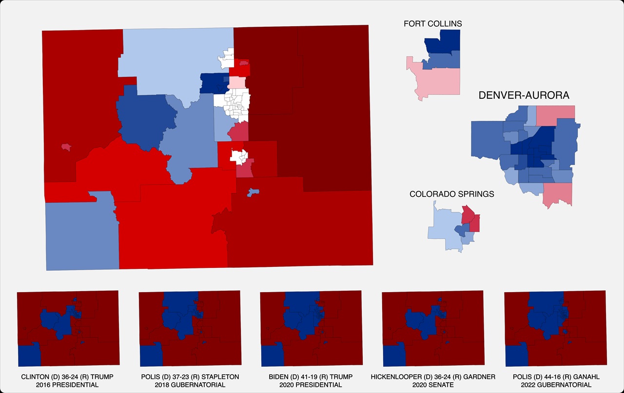
Colorado if it had 100k per house member

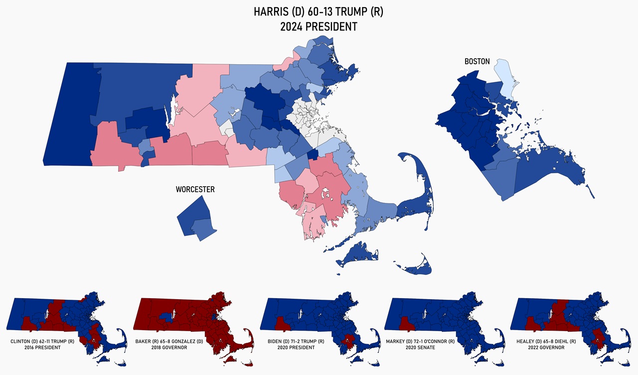
Massachusetts

Massachusetts if it had 100k per house member

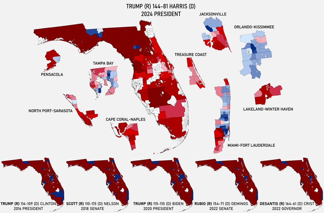
Florida

Florida if it had 100k per house member

Texas

Texas if it had 100k per house member

What do you think?

Filed Under: United States

Click To Get My 10 Best Brilliant Maps For Free:


Other Popular Maps

  • A Political Map Of Europe In 1199AD

    A Political Map Of Europe In 1199AD

  • Muslim Majority Regions In The Balkans

    Muslim Majority Regions In The Balkans

  • Map of The Swingingest Swing States In The US

    Map of The Swingingest Swing States In The US

  • The Appalachian Mountains, Atlas Mountains, Scottish Highlands and Scandinavian Mountains Were All Once Part Of The Same “Central Pangean Mountain Range”

    The Appalachian Mountains, Atlas Mountains, Scottish Highlands and Scandinavian Mountains Were All Once Part Of The Same “Central Pangean Mountain Range”

  • The Largest Puzzle In The World Is A Giant 60,000 Piece Map

    The Largest Puzzle In The World Is A Giant 60,000 Piece Map

  • What do Europeans feel most attached to: their region, their country, or Europe?

    What do Europeans feel most attached to: their region, their country, or Europe?

  • Public Road Border Crossings Between the Republic of Ireland & Northern Ireland

    Public Road Border Crossings Between the Republic of Ireland & Northern Ireland

  • Map Of The Roads Of The Roman Empire in 200AD

    Map Of The Roads Of The Roman Empire in 200AD

Comments

  1. Graham Creasey says

    May 8, 2026 at 2:17 pm

    Could the map comparing US elections with Canada be re-done with 750k people per district which would be more realistic and manageable for the US House of Representatives?

    Reply

Leave a Reply Cancel reply

Your email address will not be published. Required fields are marked *

This site uses Akismet to reduce spam. Learn how your comment data is processed.


Product Reviews · World Atlas · Settlers of Catan · Risk · Game of Thrones · Coloring Books
Globes · Monopoly · Star Wars · Game of Life · Pandemic · Ticket To Ride · Drinks Cabinets
US Locations · UK Locations· Fleet Management
Copyright © 2026 · Privacy Policy · Fair Use, Attribution & Copyright · Contact Us
Follow Us: Newsletter · Facebook · Youtube · Twitter · Threads · BlueSky · LinkedIn · Instagram · Pinterest · Flipboard