
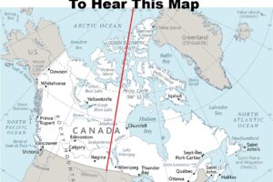
The map above shows the “border” between North and South in England and Wales (Scotland is even further North) based on a 2007 study by the University of Sheffield.
For those who don’t live in the UK, the reason for the why the map is controversial can be best summed by this comment from reddit user Flewbs:
The North-South border is extremely well-defined, just ask any Northerner and he will gladly tell you that ‘the South’ is everywhere immediately south of where he happens to live.
The map was originally created for a an exhibition at The Lowry gallery in Salford called “Myth of the North.”
Danny Dorling who helped create the map added the following information to accompany the map:
The country is best typified as being divided regionally between the north and the south. Ideas of a midlands region add more confusion than light.
The line that separates the North from the South is fractal. The closer you look at it the more detail you see. It weaves between fields and houses. That such an exact line can be drawn is, of course, a fiction but it is also fair to say that moving from North to South is not that gradual an experience.
This is the line that separates upland from lowland Britain, the hills from the most fertile farmland, areas invaded by Vikings from those first colonised by Saxons. Numerous facts of life divide the North from the South – there is a missing year of life expectancy north of this line.
Children south of the line are much more likely to attend Russell group universities for those that do go to University (and they often go to the North to study!), a house price cliff now runs along much of the line, and, on the voting map, the line still often separates red from blue.
In terms of life chances the only line within another European country that is comparable to the North-South divide is that which used to separate East and West Germany. This is found not just in terms of relative differences in wealth either side of the line, but most importantly in terms of health where some of the extremes of Europe are now found within this one divided island of Britain.
Where is it?
By county the North lies above the old counties of Gloucestershire, Warwickshire, Leicestershire and Lincolnshire and ‘nips’ only into parts of some of those counties. Most of each of those counties, and all the areas of England below them, are in the South.
By constituency the North includes and lies above the new parliamentary constituencies of the Forest of Dean on the north bank of the Severn; includes West and Mid Worcestershire, Redditch, Bromsgrove (and hence all of Birmingham), Meriden, Coventry South and North East, Warwickshire North, Nuneaton, Bosworth, Loughborough, Rushcliffe, Newark, Bassetlaw, Brigg and Goole, Scunthorpe, Cleethorpes, ending at Great Grimsby and the south bank of the Humber.
This map shows the line created by using parliamentary constituency borders.
It would be possible to go further and split some of these constituencies in half. It would be possible to identify enclaves and exclaves along the border, but this would suggest too much of a rigid line, and the border does move, especially when a new motorway is built or train line to London improved.
Within the North are places that look and sometimes act (e.g. vote) like the south. Areas around the vale of York and Cheshire are contenders here – but they are still northern. Similarly there are parts of the south, especially within London that are very unlike much of the rest of the south, but they are still southern.
Scotland and Wales are part of the North, despite having managed to eschew the Victorian attempts to label them North and West Britain respectively.
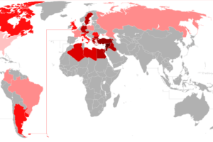
And here’s another map created by Ryan Starkey (A Northerner) on where the North/South divide is:

To learn more about the North-South divide in the UK, the following books may be helpful:
What do you think about the map? Leave your comments below and share it with a friend who might diasgree:


ale bro says
The north starts at the Watford Gap!
John says
Possibly, but SW – NE through it?
Most of my secondary schooling was in Bristol; the North was not close by.
robertsonjames says
Sorry but any definition of the North of England which even includes parts of Gloucestershire and the Severn estuary falls at the first hurdle of basic plausibility. If it’s simply about social exclusion and worse life-chances you might as well include Plymouth or the Medway towns, never mind significant parts of London.
Dan says
The line is OK but taking into account local culture and poverty statistics I would draw a line from Coventry to Bath and down to Dorchester, thus including the Bristol area and Devon and Cornwall, who generally do not like to be bracketed with “Southerners” My divide is more North and West/South and East.
Garmon Ceiro says
Rubbish. Wales is a seperate country. It is most certainly NOT in the north of England.
alic says
exactly! it’s a bit dumb
Elle says
If we’re going to pretend the Midlands isn’t a separate entity then Lincolnshire should be considered the North.
Geoff Clarke says
Look at the geological map of the UK…notice similar trend?
https://en.wikipedia.org/wiki/Geology_of_Great_Britain
Robert Downey Senior says
This probably fits better…
https://en.m.wikipedia.org/wiki/Lloegyr
Ste says
Nottingham and Birmingham aren’t northern and Wales and Scotland are to their own, though I can related to them far more than most southerners.
Cornick says
I rather like the line as drawn, but in the commentary I think it should be noted that the rugged, rocky physical geography of Devon and Cornwall – including the UK’s most southerly point The Lizard – is distinctly Northern.
Iain Cheyne says
Similar line to the first frontier that the Romans set up after they invaded. The Fosse Way marks the boundary. https://en.wikipedia.org/wiki/Fosse_Way
Kris Hughes says
Yeah, I feel like this is kind of a reflection of the difference between the part of the country that kind of accepted Romanisation, and the part which was just “under occupation”. That statement lacks nuance, but I think it’s broadly true. And maybe this reflects the different topography, which is in turn reflected in cultural difference that even changing ethnicities don’t entirely erode.
Raymond Hopkins says
There are bound to be disagreements, but the line shown here is not such a bad fit , especially when compared to the old Danelaw areas. As aNortherner myself fro the Teesside region, I feel I have much more in common with Denmark than with London. Language, in the dialect form, for one.
Peter says
I think it’s about time we dismiss this myth of a North/South divide. Just ask any Midlander how fed up they are with this rubish.
Geoff Whitehead says
I have always thought that the real, economic, dividing line is the “Wash to Weymouth” line. Cornwall and Devon are most definitely not on the ‘high income’ side of the line.
Dom McKenzie says
The comment about no other country having such a stark difference between extremes is clearly wrong – he cites Germany. I would say that Italy has even greater differences between North & South; although it is a mirror image with the North richer & the South poorer. Indeed, there is a movement by some well off Northern Italians to break away and leave the Southern Italians as a separate country – Nordxit?
Kris Hughes says
Border regions are always interesting. Society, culture, dialects, attitudes along this line are very often divided by poverty/affluence.
Wales does and doesn’t belong in this “North”, and of course has its own north/south divide with an entirely different meaning and set of criteria. But I get why the map maker put it there.
Being from Edinburgh, I kind of see “northern England” as “the part of England where I still feel at home” – so I might draw the line further north in places, but it feels about right.
R Burns says
The North of England, or as we call it in Scotland, the South.