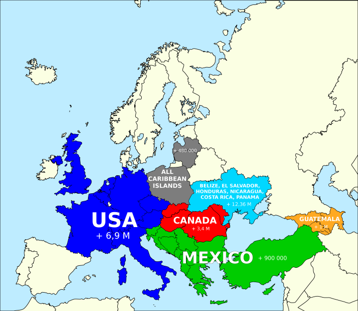
Based on this popular post around the idea of how you can fit the population of the United States into various countries. The map above looks at how you could fit the population of North America into Europe, and still have several million people left over.
The US roughly fits into these countries:
- Germany
- France
- United Kingdom
- Italy
- Netherlands
- Belgium
- Czech Republic
- Austria
- Switzerland
Canada roughly fits into:
- Slovakia
- Hungary
- Romania
- Moldova
Mexico roughly fits into:
- Turkey
- Greece
- Bulgaria
- Macedonia
- Albania
- Kosovo
- Serbia
- Montenegro
- Bosnia and Herzegovina
- Croatia
- Slovenia
The Caribbean can fit into:
- Poland
- Lithuania
- Latvia
Guatemala has a similar number of people as:
- Georgia
- Armenia
- Azerbaijan
Belize, El Salvador, Honduras, Nicaragua, Costa Rica and Panama have about 12 million fewer people than the Ukraine with Crimea or 10 million fewer than the Ukraine without Crimea.
Finally keep in mind that North America is 24.7 million km2 vs Europe’s 10.2 million km2 and yet there are still nearly 200 million Europeans we haven’t counted in the map above. That’s why, depending on your perspective, Europe is either really crowded or North America is really empty.
To learn more read:
- Guns, Germs, and Steel: The Fates of Human Societies
- Europe: A History
- An Indigenous Peoples’ History of the United States (ReVisioning American History)
Have any thought on the map above? Leave them in the comment section below:


Jerry Slaff says
And of course, SCTV’s “What Fits Into Russia”: https://www.youtube.com/watch?v=BXqKkYYALMU
Brilliant Maps says
Absolute classic. Love it.
Geography 101 says
There’s this thing called Central America. More than half of the countries you mention as being part of North America are not. You would be shot if you say this non sense in any of these countries. Just a heads up.
Brilliant Maps says
Duly noted, will stay away from those countries.
Israel Navas Duran says
English speaking countries tend to divide America into two continents, North and South America. Therefore, Central America has to fall into one of the two. Paleo-geologically it’s more accurate to assign it to North America (up to Panama) since they’ve been together a large land mass for longer, whereas the connection of Central America to South America is much more recent, thePanama seaway didn’t get definitely closed until about two million years ago.
Kevin Loría says
This is nonesense. You sir should confirm your facts before you post wrong information. The map itself it’s ok, but North America it’s only Canada, USA, and Mexico. The rest of them are Central America. This is not about if you’d get shot to say this in any of these countries, but to show some respect to your readers, actually knowing what you are posting. As a Costa Rican political science student I consider this not only a lack of responsibility but also a little smug attitude from you answering you would not go to any of these countries. Absolutely wrong. Not reading you again.
Brilliant Maps says
Well as a political science student you may wish to read up on your geography http://en.wikipedia.org/wiki/North_America#Geography_and_extent
Israel Navas Duran says
In Spanish-speaking countries (and probably some others such as Italy) America is generally considered one single continent, and then it’s divided into three parts, North, Central and South America.
From a paleo-geological perspective such division doesn’t have any sense (similarly to the division of Europe and Asia into two continents), but it predates plate tectonics and continental drift.
KuFY says
The continent of North America absolutely includes Central America. It seems like you are referring to the political region of Central America – the geographical continent of Central America is non-existent. Panama is located on the isthmus connecting North and South America. However, I suspect you know this (as a political science student), and that you just wanted to discredit the post.
– Political science student 2
brian says
Surely these are simply man-made designations and don’t really matter much? You might as well get pissed off about someone who has the temerity to call the Adriatic the Mediterranean. I personally think Australia is an island but I’m not going to boycott this blog for calling it a continent.
Israel Navas Duran says
If Australia is an island, why not the Antarctica?
Luke Sebastian Scalone says
If Antarctica and Australia are both islands, why not Eurasia?
Diegozpy says
Hello from panama 🙂
Guest says
There’s some misunderstanding here. North America, by definition, is comprised only by Canada, Mexico and the U.S.A.
“Central America and the Caribbean” are a separate geographical entity, being considered a subcontinent inside America, composed by the isthmus contries between Guatemala and Panama, as well as the islands of the Caribbean Sea.
Piet van den Berg says
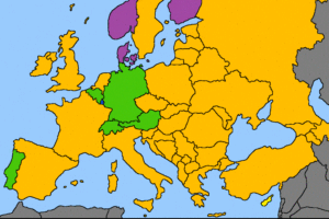
Cool, but I would say this division is perhaps slightly better
https://uploads.disquscdn.com/images/821e1c30a42fe5f3a5cbeab14a8984a40a53f2c7493ee5517b735c50189bbb2e.jpg
More actual Europe-based, and the empty/cold countries are Canada while the latin/hot countries are Mexico.
Rafael says
Much better indeed. Thanks
ElAnon says
What a lazy map, you could map may smaller countries to other places. For example Dominican Republic has approximately the same population as Sweden, Puerto Rico the population is similar to Finland.