
The map above is Francis Galton’s earliest known isochronic map, published in 1881 for the Proceedings of the Royal Geographical Society, illustrates travel times from London, United Kingdom, to various parts of the world, measured in days.
The map assumes favorable travel conditions, prearranged land transport, and the use of contemporary travel methods within a reasonable cost.
From the map itself:
ISOCHRONIC PASSAGE CHART FOR TRAVELLERS,
showing the shortest number of days journey from London by the quickest through routes and using such further conveyances as are available without unreasonable cost.
It is supposed that local preparations have been made and that other circumstances are favorable.
By Francis Galton, F.R.S.
Explanation of colours:
- Green: within 10 days
- Yellow: 10-20 days
- Pink: 20-30 days
- Blue: 30-40 days
- Brown: more than 40 days journey.
Travel Times From London
- Europe: Mostly green, indicating travel within 10 days.
- North Africa and parts of the Middle East: Green and yellow, reachable within 10–20 days.
- India and Southeast Asia: Pink, implying travel times of 20–30 days.
- North America (Eastern Coast): Yellow, reachable within 10–20 days; the western parts are pink or blue.
- South America: A mix of pink, blue, and brown, with many areas requiring more than 30 days.
- Australia and New Zealand: Brown, taking over 40 days to reach.
- Sub-Saharan Africa: Pink and brown, with inland regions taking over 40 days.
- East Asia (e.g., China and Japan): Predominantly brown, reachable in over 30 days.
- Polar regions: Uncolored, implying travel to these areas was not possible with regular routes.
What is an Isochronic (or travel time) Map?
An isochronic map is a type of map that visualizes the time it takes to travel from one location to various other locations around the world.
The term “isochronic” or “isochrone” derive from the Greek words “iso” (equal) and “chronos” (time), meaning “equal time.”
These maps use different colors or lines to represent regions that can be reached within the same amount of time from a central point, often taking into account transportation modes and infrastructure of a given period.
Why Are Isochrone Maps Useful?
- Understanding Historical Travel Patterns:
- Isochronic maps, like Francis Galton’s 1881 map, provide a fascinating snapshot of travel conditions in a specific era. They illustrate how advancements in transportation (e.g., steamships, railroads) revolutionized travel and connectivity.
- Planning Travel and Logistics:
- Isochronic maps help travelers, planners, and logisticians estimate travel times. This is especially valuable when managing supply chains, arranging meetings, or planning trade routes.
- Analyzing Accessibility:
- These maps reveal areas that are easier or harder to access within certain timeframes. This can guide decisions about infrastructure development or investment.
- Historical and Geographic Insights:
- For historians and geographers, isochronic maps provide insight into the social, economic, and technological factors shaping mobility in different time periods.
- Comparing Transportation Evolution:
- Comparing modern isochronic maps with historical ones highlights how transportation technology (like airplanes, highways, and high-speed trains) has drastically reduced travel times and reshaped global connectivity.
Who was Francis Galton?
Francis Galton (1822–1911) was a highly influential and multifaceted British scientist, geographer, and polymath.
While he is best known for his work in statistics, genetics, and eugenics, his contributions to geography and cartography were also significant, especially in the 19th century.
Key Contributions to Geography:
- Isochronic Maps:
- Galton pioneered the creation of isochronic maps, which visually represented travel times from a central location (such as London) to other parts of the world. His 1881 map, published for the Proceedings of the Royal Geographical Society, was a groundbreaking tool for understanding global accessibility during the late 19th century (see above). These maps showcased the impact of transportation technology like railroads and steamships on travel efficiency.
- Meteorology and Climate Mapping:
- Galton was instrumental in advancing meteorology and developing weather mapping techniques. He introduced the concept of isobars, lines on a map that connect points of equal atmospheric pressure, which are now standard in weather forecasting.
- Geographical Exploration and Fieldwork:
- In his early career, Galton conducted exploratory expeditions, particularly in Africa. One of his notable expeditions was to Southwest Africa (modern-day Namibia), where he mapped and documented the region, earning recognition from the Royal Geographical Society.
- Innovative Visualization:
- Galton was a pioneer in using graphical and statistical techniques to represent geographical and scientific data. His methods improved how spatial and temporal data were visualized, influencing modern cartography and data visualization.
Broader Achievements:
- Galton was a cousin of Charles Darwin, and his intellectual interests extended beyond geography to include statistics, psychology, and anthropology.
- He invented statistical concepts like regression to the mean and developed the first methods for fingerprint analysis.
- Galton founded the field of eugenics, though this part of his legacy has been widely criticized and discredited due to its unethical implications.
Recognition:
- Galton was a Fellow of the Royal Geographical Society (RGS) and the Royal Society. His contributions earned him multiple awards, including the Royal Geographical Society’s prestigious Founder’s Medal.
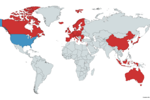
And finally here’s a more modern take on the map created by Atlasova:
For an update on this format see: Travel Times From London in 2016 vs 1914


Leave a Reply