Brilliant Maps

Making Sense Of The World, One Map At A Time

  • BOOK!
  • Newsletter
  • Board Games
  • Posters
  • Scratch Maps

Palestine’s West Bank Archipelago

Last Updated: June 17, 2024 13 Comments

Click To Get My 10 Best Brilliant Maps For Free:

Palestine Archipelago

Map created by Julien Bousac
The map above shows what Palestine’s West Bank would look like if all non-Palestinian land suddenly turned into water.

All that would remain would be an archipelago of small islands with the sea of Israel to the west and the Jordanian ocean to the east.

[Read more…]

Filed Under: Fictional, Other

Star Wars Plot Maps Of The Original Trilogy

Last Updated: March 3, 2023 Leave a Comment

Click To Get My 10 Best Brilliant Maps For Free:

Map of Star Wars A New Hope

Map of Star Wars A New Hope created by Andrew DeGraff

The 3 Star Wars maps presented here are possibly some of the coolest and most original maps we’ve ever featured. They are the brainchild of freelance illustrator and artist Andrew DeGraff.

Each map shows the paths of the major characters in each of the original Star Wars trilogy films.

[Read more…]

Filed Under: Fictional Tagged With: star wars

Map Of The Town of Springfield From The Simpsons

Last Updated: March 3, 2023 8 Comments

Click To Get My 10 Best Brilliant Maps For Free:

Map of the The Town of Springfield From The Simpsons

Map created by Jerry Lerma and Terry Hogan

The map above shows the town of Springfield from the Simpsons. It was created by Jerry Lerma and Terry Hogan (with the link to their website sadly no longer working) and states it was last revised on May 26th 2004.

This suggests the map is only accurate up to the end of season 15 (the show is currently on season 27).

[Read more…]

Filed Under: Fictional

The United States If The Annexation Bill of 1866 Had Passed

Last Updated: March 3, 2023 37 Comments

Click To Get My 10 Best Brilliant Maps For Free:

The United States If The Annexation Bill of 1866 Had Passed

Map created by user Rubberduck3y6 of alternatehistory.com via Wikipedia

The map above shows what an alternate United States might have looked like if the The Annexation Bill of 1866 had passed.

[Read more…]

Filed Under: Canada, Fictional, United States

8 Wizarding School Locations from Harry Potter

Last Updated: February 5, 2025 123 Comments

Click To Get My 10 Best Brilliant Maps For Free:

Wizarding School Locations from Harry Potter

Map created by Pottermore.com
The map above shows the locations of the 7 Wizarding schools that have been revealed so far, that exist in the Harry Potter universe.

[Read more…]

Filed Under: Fictional Tagged With: books

Game of Thrones’ Westeros At Night – Dark And Full of Terrors

Last Updated: March 3, 2023 7 Comments

Click To Get My 10 Best Brilliant Maps For Free:

Westeros-Night

Map of Wetseros at Night, part of Planetos at night map via Imgur

The map above shows what Westeros (from Game of Thrones) might look like at night if it could be viewed from space. In the North you can see the lights along The Wall.

[Read more…]

Filed Under: Fictional Tagged With: Game of thrones

How New Yorkers See The World: View of the World from 9th Avenue

Last Updated: March 3, 2023 3 Comments

Click To Get My 10 Best Brilliant Maps For Free:

View of the world from 9th ave

Map created by Saul Steinberg on behalf of the The New Yorker

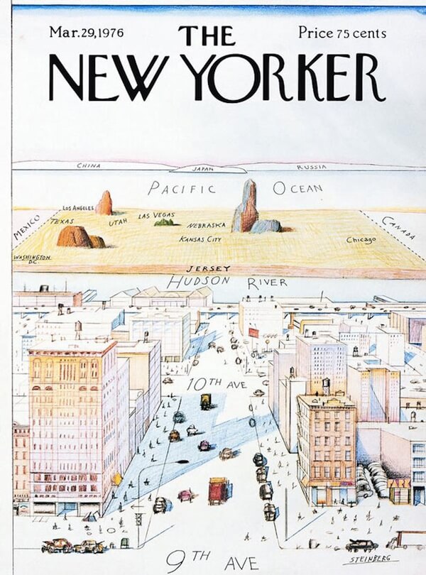
View of the World from 9th Avenue is a classic map/illustration showing how New Yorkers see the rest of the world. Designed by Saul Steinberg, it was first published as the cover for the March 29, 1976, edition of The New Yorker.

[Read more…]

Filed Under: Fictional Tagged With: humour

Google Map Style Game of Thrones Westeros

Last Updated: January 16, 2025 1 Comment

Click To Get My 10 Best Brilliant Maps For Free:

Westeros, Essos and The Known World of Game of Thrones, Google Maps-style

Map created by reddit user selvag.

The map above shows the entire ‘Known World’ from Game of Thrones including Westeros and Essos in a Google map style.

[Read more…]

Filed Under: Fictional Tagged With: Game of thrones

What If the Mongol Empire Reunited….?

Last Updated: May 12, 2025 11 Comments

Click To Get My 10 Best Brilliant Maps For Free:

Mongol Empire Reunited

Map created by reddit user Trapper777_

The Mongol Empire was the largest contiguous land based empire in history. So what would a modern Mongol state look like today if it hadn’t disappeared?

[Read more…]

Filed Under: Fictional, History Tagged With: Mongol

Game of Thrones’ Westeros Is Really Just Britain & An Inverted Ireland

Last Updated: March 3, 2023 27 Comments

Click To Get My 10 Best Brilliant Maps For Free:

Westeros as Britain & Ireland

Map created by reddit user KingofFairview

The map above clearly shows that Westeros, from the Game of Thrones TV series and the Song of Ice and Fire book series, is nothing more than Britain placed on top of an inverted Ireland.

However, looks can be deceiving since there are some pretty key differences between Westeros and the British Isles. Here are just a few:

[Read more…]

Filed Under: Fictional Tagged With: Game of thrones

  • « Previous Page
  • 1
  • 2
  • 3
  • Next Page »


Product Reviews · World Atlas · Settlers of Catan · Risk · Game of Thrones · Coloring Books
Globes · Monopoly · Star Wars · Game of Life · Pandemic · Ticket To Ride · Drinks Cabinets
US Locations · UK Locations· Fleet Management
Copyright © 2026 · Privacy Policy · Fair Use, Attribution & Copyright · Contact Us
Follow Us: Newsletter · Facebook · Youtube · Twitter · Threads · BlueSky · LinkedIn · Instagram · Pinterest · Flipboard