
On October 5 1960, South Africa held a referendum on severing its ties to the British Crown and becoming a republic.
Making Sense Of The World, One Map At A Time
On October 5 1960, South Africa held a referendum on severing its ties to the British Crown and becoming a republic.
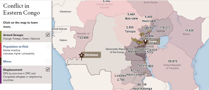
The map above shows the location of armed groups (in green) and the areas with the number of internally displaced people (in purple) in the Eastern Congo.
The map was put together by the Council on Foreign Relations as part of their Eastern Congo InfoGuide Presentation.

While it doesn’t look it, Africa is big, really big. In fact, Africa’s true size is 30 million square km, just under twice the size of Russia or bigger than Canada, the United States and China put together!

Basically, Islam dominates the North and East of the continent, while Christianity dominates the South and West, with other native and folk religions being scattered throughout.

The map above shows how the African continent was divided in 1914 just before the outbreak of World War I. By this time, European powers controlled 90% of the continent with only Abyssinia (Ethiopia) and Liberia retaining independence.