Brilliant Maps

Making Sense Of The World, One Map At A Time

  • BOOK!
  • Newsletter
  • Board Games
  • Posters
  • Scratch Maps

Conflict in Eastern Congo Mapped

Last Updated: March 3, 2023 Leave a Comment

Click To Get My 10 Best Brilliant Maps For Free:

Conflict in Eastern Congo Mapped

Map created by the Council on Foreign Relations, click for interactive version

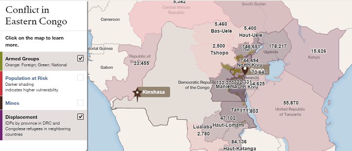
The map above shows the location of armed groups (in green) and the areas with the number of internally displaced people (in purple) in the Eastern Congo.

The map was put together by the Council on Foreign Relations as part of their Eastern Congo InfoGuide Presentation.

The Democratic Republic of the Congo (DRC) is the 2nd largest country in Africa (after Algeria) and home to over 85 million people, making it the world’s most populous country with French as an official language.

The conflict in the Eastern Congo has been going on for nearly two decades and is one of the deadliest since World War 2. Since 1994, it’s estimated that up 5.4 million people have been killed and that 3 million people remain displaced today.

Unfortunately civilians, especially women, have been targeted, often simply being from the wrong ethnic group.

The current conflict in the Eastern Congo has it’s roots in the Rwandan genocide of 1994, when many of the Hutus who perpetrated the genocide, fled into the DRC after being forced out of Rwanda.

You can read the full story on CFR’s website.

If you’re interested in learning more about the Congo’s complex history, consider the following books:

  • King Leopold’s Ghost: A Story of Greed, Terror, and Heroism in Colonial Africa
  • Dancing in the Glory of Monsters: The Collapse of the Congo and the Great War of Africa
  • Congo: The Epic History of a People

Find this post interesting? Please help us by sharing it:

Filed Under: Africa Tagged With: congo

Click To Get My 10 Best Brilliant Maps For Free:


Other Popular Maps

  • Costco vs Sam’s Club Store Numbers By US State

    Costco vs Sam’s Club Store Numbers By US State

  • Could Terrible Maps Brilliantly Awful Two State Solution Map Work?

    Could Terrible Maps Brilliantly Awful Two State Solution Map Work?

  • Sunlight Hours Across Europe on The Shortest Day of the Year (Winter Solstice; Dec 21)

    Sunlight Hours Across Europe on The Shortest Day of the Year (Winter Solstice; Dec 21)

  • How Every US County Voted In 2016, 2020 & 2024

    How Every US County Voted In 2016, 2020 & 2024

  • Travel Times From London In 1881: The First Known Isochronic Map By Francis Galton

    Travel Times From London In 1881: The First Known Isochronic Map By Francis Galton

  • Minority Languages in France

    Minority Languages in France

  • Brasilia, Has Direct Flights To All Brazilian State Capitals

    Brasilia, Has Direct Flights To All Brazilian State Capitals

  • Number of Books Banned By Schools In Each US State: Including Most Banned Books & Authors

    Number of Books Banned By Schools In Each US State: Including Most Banned Books & Authors

Leave a Reply Cancel reply

Your email address will not be published. Required fields are marked *

This site uses Akismet to reduce spam. Learn how your comment data is processed.


Product Reviews · World Atlas · Settlers of Catan · Risk · Game of Thrones · Coloring Books
Globes · Monopoly · Star Wars · Game of Life · Pandemic · Ticket To Ride · Drinks Cabinets
US Locations · UK Locations· Fleet Management
Copyright © 2026 · Privacy Policy · Fair Use, Attribution & Copyright · Contact Us
Follow Us: Newsletter · Facebook · Youtube · Twitter · Threads · BlueSky · LinkedIn · Instagram · Pinterest · Flipboard