 Map created by reddit user PisseGuri82
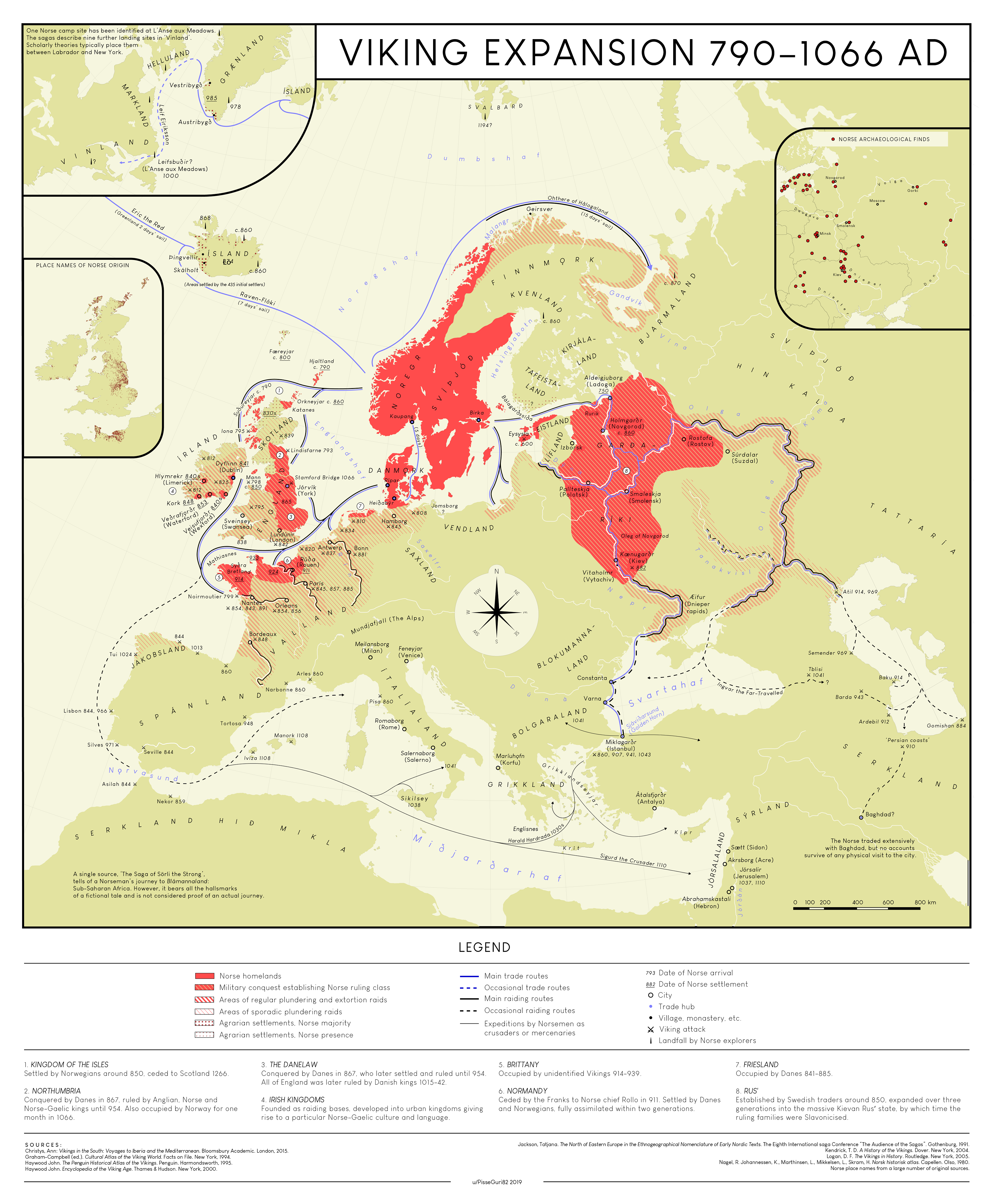
The map above is a stunningly detailed look at Viking Expansion between 790 and 1066.
Here’s what’s included in the legend:
LEGEND
- Norse homelands
- Military conquest establishing Norse ruling class
- Areas of regular plundering and extortion raids
- Areas of sporadic plundering
- Areas of settlement, some majority Scandinavian
- Areas of settlement, Norse minority
- Main trade routes
- Occasional trade routes
- Occasional raiding routes
- Excursions inland
- Exploits by Norsemen as invaders or mercenaries
- Tribe hub
- Viking monastery site
- Viking attack
- Landfall by Norse explorers
- Date of Norse arrival
- End of Norse settlement
Below the legend on the map, there some text summarizing specific Viking-influenced regions.
Here’s the extracted text:
- KINGDOM OF THE ISLES
Settled by Norwegians around 850, ceded to Scotland 1266.
- NORTHUMBRIA
Captured by Danes in 867, ruled by Anglo, Norse and Anglo-Danish kings until 954. Also occupied by Norse from north in 918.
- THE DANELAW
Captured by Danes in 867–80, later settled and ruled until 954. Area of limited revival by Danish kings 1013–42.
- IRISH KINGDOMS
Power struggle between diverse existing Irish kingdoms gave rise to particular Norse-Gaelic culture and language.
- BRITTANY
Occupied by unidentified Vikings 914–919.
- NORMANDY
Given by Franks to Norse chief Rollo in 911. Settled by Danes and Norwegians who assimilated into local Frankish population.
- RUS
Occupied by Danes 841–882.
- FRISIA
Taken by Swedish traders around 850, expanded over three centuries to dominate the Slavic Rus. Built by this time the first towns known in Scandinavia.
And here’s the author of the map explaining a bit more about it:
Yes, I also have an issue with the existing maps almost always trying to colour in Norman Sicily for some reason.
Yes, Normans were decendants of Vikings. Yes, 19th century nationalistic historians did utilise them as extensions of Scandinavian conquests and that idea has carried over in a lot of historical maps even today. However, the “Vikings expansions” are, as per current historians’ consensus, a specific term with a specific definition, and that is the travels of “Norse explorers, traders and warriors”.
The Normans did not speak Norse, they did not follow Norse customs, and they did not utilise Norse raiding/military tactics. They were French-speaking Catholic dukes of the Frankish King, their conquest of Sicily and Italy was dependent on heavy cavalry, a tactic completely alien to the Vikings.
The Normans were 3-4 generations removed from their Norse-born ancestors, just like a lot of people in Minnesota today are 3-4 generations removed from their Scandinavian-born ancestors. Already Rollo’s son, William Longsword, faced a rebellion by his father’s generation who felt he had become too Gallic.
To call his grand- and great grandchildren Norse is a stretch.
The Normans have a place in Viking history, but they are an addendum and they are not within the scope of “Viking expansions”. Note that the territory of the Rus’ is depicted here precicely as it was at the time they became Slavonicised, the settlements in Iceland precicely as they were during the first stage of settlement, etc.
The territory of the Normans is also depicted as it was at the time they became Gallicised around 950.
You can read more about it from the original reddit thread here.
Below is another map showing what the world would have looked like If the Vikings’ assumptions about world geography were accurate:

Names from the map:
| Norse Name | Modern Equivalent | Explanation |
|---|---|---|
| Helluland | Baffin Island (Canada) | Mentioned in Norse sagas as a land of flat stones, one of the lands west of Greenland discovered by Leif Erikson. |
| Markland | Labrador (Canada) | Another land from the Vinland sagas, meaning “Forest Land.” Believed to correspond to modern Labrador. |
| Vinland | Newfoundland (Canada) or further south | “Wine Land,” discovered by Leif Erikson; described as fertile and mild compared to Greenland. |
| Groenland | Greenland | Literally “Green Land,” named by Erik the Red to attract settlers. |
| Island | Iceland | “Island” or “Ice Land,” the Norse homeland in the North Atlantic. |
| Svalbard | Svalbard (Norway) | Archipelago north of mainland Norway; name means “cold coast.” |
| Norger / Sviþjod | Norway / Sweden | “Noregr” (Norway) and “Svíþjóð” (Sweden) in Old Norse. |
| Danmork | Denmark | “Borderland of the Danes.” |
| Finland | Finland | Same as modern name; part of the Viking trade and war routes. |
| Gardariki | Russia (Kievan Rus) | “The Realm of Towns,” Norse name for the eastern lands around Novgorod and Kiev. |
| Saxland | Germany | Land of the Saxons. |
| Frakkland | France | Land of the Franks. |
| Spánland | Spain | The Iberian Peninsula; known from Norse sagas. |
| Grikkland | Greece / Byzantine Empire | “Land of the Greeks”; often used for the Byzantine Empire (Miklagarðr was specifically Constantinople). |
| Tyrkland | Turkey / Asia Minor | Land of the Turks; corresponds to Anatolia. |
| Serkland | The Islamic World (Middle East, Arabia) | Norse term for lands inhabited by “Saracens,” i.e., Muslim peoples. |
| Egiptaland | Egypt | Known from Norse sources; land of the Pharaohs and biblical tales. |
| Bláland | Africa (specifically North or Sub-Saharan Africa) | “Land of the blue/black people,” Norse term for Africa or Ethiopia. |
| Atlanterhavet | The Atlantic Ocean | Literally “Atlantic Ocean.” |
This map represents how a Norse explorer or geographer might have envisioned the world, with:
- A north-oriented perspective (centered around the North Atlantic),
- Norse names for known and semi-mythical lands,
- A focus on the Viking exploration sphere (North Atlantic and Europe),
- Limited awareness of sub-Saharan Africa or Asia beyond the “Serkland” and “Egiptaland” regions.
What do you think?


Leave a Reply