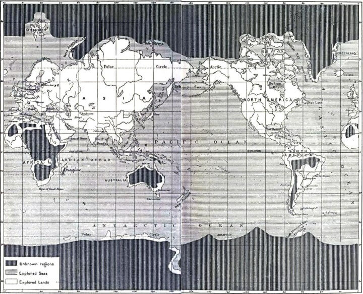
The map above appeared in Jules Verne’s The Great Explorers of the Nineteenth Century and shows the areas of the world that remained unexplored (to Westerners) in 1881.
While all of Europe, Asia and North America had been fully explored by 1881, the interiors of South America, Australia, and Africa had yet to be fully explored and mapped. Moreover, Antarctica and The Arctic were still almost entirely unknown.
Keep in mind that when this map was produced, the Berlin Conference, that formalized the Scramble for Africa, was still 3 years in the future. The South Pole would not be reached until 1911 by Norwegian explorer Roald Amundsen.
Finally, there is some debate as to when the the North Pole was reached. It was first reached in either 1908 by Frederick Cook, 1909 by Robert Peary or as late as 1926 by Roald Amundsen, who was the first undisputed person to reach it.
You can read the full copy of The Great Explorers of the Nineteenth Century for free on Kindle.
To learn more about exploration in the 19th century have a look at the following books:
- The Last Blank Spaces: Exploring Africa and Australia
- The Last Viking: The Life of Roald Amundsen (A Merloyd Lawrence Book)
- The Explorers: A Story of Fearless Outcasts, Blundering Geniuses, and Impossible Success
- The Scramble for Africa: White Man’s Conquest of the Dark Continent from 1876 to 1912
- Mapping the World: The Story of Cartography
Enjoy this post? Please help us by sharing it:
Physics Bill says
This map is inaccurate as regards Australia. Numerous explorers had transited inland Australia by 1881 and in fact there was an overland telegraph line running North/South through the center of Australia (Adelaide to Darwin) in operation by 1872.
Dean says
This map is totally wrong and probably also quite a bit racist. Australian inland was explored by humans many thousand years ago. The African inland was also not only discovered but populated by humans hundreds of thousand years ago.
Arne Melsom says
The Franz Josef Land archipelago in the NE corner of the Barents Sea was explored in the 1860s and 1870s.