Brilliant Maps

Making Sense Of The World, One Map At A Time

  • BOOK!
  • Newsletter
  • Board Games
  • Posters
  • Scratch Maps

Clan Map of Ireland

Last Updated: March 3, 2023 5 Comments

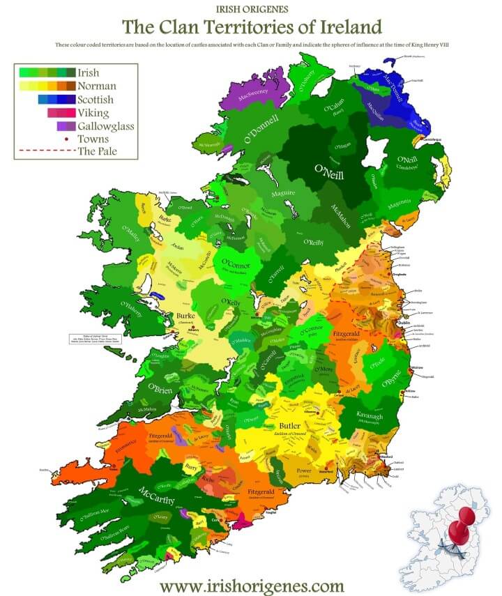
Clan Map of Ireland

Map created by irishorigenes.com

The map above shows the location of over 400 of the most prominent historic clans and families in Ireland. And it includes whether they had an Irish, Scottish, Gallowglass, Norman, or Viking historical association.

The time period is roughly during the reign of King Henry VIII (1509-1547), prior to the complete English conquest of Ireland in the 16th and 17th centuries.

At this time, the area under English authority was known as The Pale (area around Dublin) and is shown on the map as well. Interestingly, the term ‘beyond the pale’ (meaning outside the bounds of acceptable behaviour) may have its origins with Irish Pale.

Finally the map also shows the principle towns that existed in Ireland at the time.

If you’d like to buy a copy of the map you can do so here.

To learn more about Ireland’s clans and families have a look at the following books:

  • Clans and Families of Ireland: The Heritage and Heraldry of Irish Clans and Families
  • A New Genealogical Atlas of Ireland, Second Edition
  • Tracing Your Irish Ancestors: The Complete Guide. Fourth Edition

Enjoy this map? Please help us by sharing it with a friend.
Filed Under: History Tagged With: Ireland

Other Popular Maps

  • European Borders In 1914 vs Borders Today

    European Borders In 1914 vs Borders Today

  • 21 Unique Monopoly Board Game Versions You Can Buy Online

    21 Unique Monopoly Board Game Versions You Can Buy Online

  • 37 Eye-Catching World Map Posters You Should Hang On Your Walls

    37 Eye-Catching World Map Posters You Should Hang On Your Walls

  • More People Live Inside This Circle Than Outside Of It

    More People Live Inside This Circle Than Outside Of It

  • Controversial Cultural North-South Divide Map of England & Wales

    Controversial Cultural North-South Divide Map of England & Wales

  • A Map of Superheroes in NYC & The Areas They Protect

    A Map of Superheroes in NYC & The Areas They Protect

  • Mesmerizing Map Of Global Aerosol Pollution

    Mesmerizing Map Of Global Aerosol Pollution

  • Top 10 Most Popular Explorer & Landranger Ordnance Survey Maps

    Top 10 Most Popular Explorer & Landranger Ordnance Survey Maps

Comments

  1. Zoe Porphyrogenita says

    September 15, 2017 at 12:33 pm

    “Norman” often means Breton. For example, Tobin is from St Albinus of Vannes, Bishop of Angers from 529 to 550.

    Reply
    • Mic O¶”sAinT~Marshe°¶ says

      November 24, 2018 at 6:20 am

      Hey that is Interesting Thanks But did they still speak the BRETONÈ Language is recently re-doubled the Struggle to Keep the full Beauty of its Lexicon and Accent!!
      Good Luck From An Mic&M. (Half Kiwi! &Celtic Man;)*

      Reply
  2. P says

    October 13, 2018 at 2:22 am

    Principle towns? I don’t think so.

    Reply
  3. Toby says

    April 12, 2019 at 11:01 pm

    Archdeacon/MacOdo/Cody is missing. Should be near Kilkenny (Norman)

    Reply
  4. Macca says

    June 16, 2019 at 12:24 pm

    “Scottish”? Those “Scots” originally came from Ireland. The whole of Scottish Gaelic culture comes from Ireland.

    Reply

Leave a Reply Cancel reply

Your email address will not be published. Required fields are marked *

This site uses Akismet to reduce spam. Learn how your comment data is processed.


World Atlas · Settlers of Catan · Risk · Game of Thrones · Coloring Books · Globes
Monopoly · Star Wars · Game of Life · Pandemic · Ticket To Ride · Drinks Cabinets
Copyright © 2023 · Privacy Policy · Fair Use, Attribution & Copyright · Contact Us
Follow Us: E-mail · Twitter · Facebook · Pinterest · Flipboard