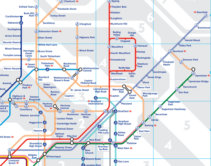
London’s tube map, arguably the most famous transportation map in the world, has just been updated for 2015. The reason is that Transport of London (TFL), which makes the map, has added some new services.
For those not living in London, TFL are the government body responsible for a large part of the transportation system of London. In addition to running London Underground they also run:
- Overground (orange)
- DLR (light blue)
- Cable Car
- Trams (in south London and not part of the tube map)
- Busses (not on tube map)
- River Bus (not on tube map)
- Congestion charge zone
- London Streets
- TFL Rail (newest service and a precursor to Crossrail, in cased dark blue above)
The new services are all located in East London, (section above), which means it’s starting to look a little crowded. The big addition is TFL rail, a new service that will turn into Crossrail in 2018/19. As of right now it runs from Liverpool Street to Shenfield, which will add another zone 9 station to Chesham and Amersham.
Other changes include:
- The addition of 28 new stations to map.
- New Overground services going to Enfield Town, Cheshunt and Chingford.
- New 3 station Overground line from Romford to Upminster.
- Kink in the central line between Queensway and Bond Street, which will leave space on the map for Crossrail.
- The addition of a second Bethnal Green station.
- Tufnell Park has a red line through it to show that it will be closed while they upgrade the lifts.
- The cable car is still there…
Notice anything else interesting? Leave your comments below:


Leave a Reply