Brilliant Maps

Making Sense Of The World, One Map At A Time

  • BOOK!
  • Newsletter
  • Board Games
  • Posters
  • Scratch Maps

A Beautiful Hand-Drawn Map Of The British Isles during the First War of Scottish Independence

Last Updated: August 5, 2026 Leave a Comment

Click To Get My 10 Best Brilliant Maps For Free:

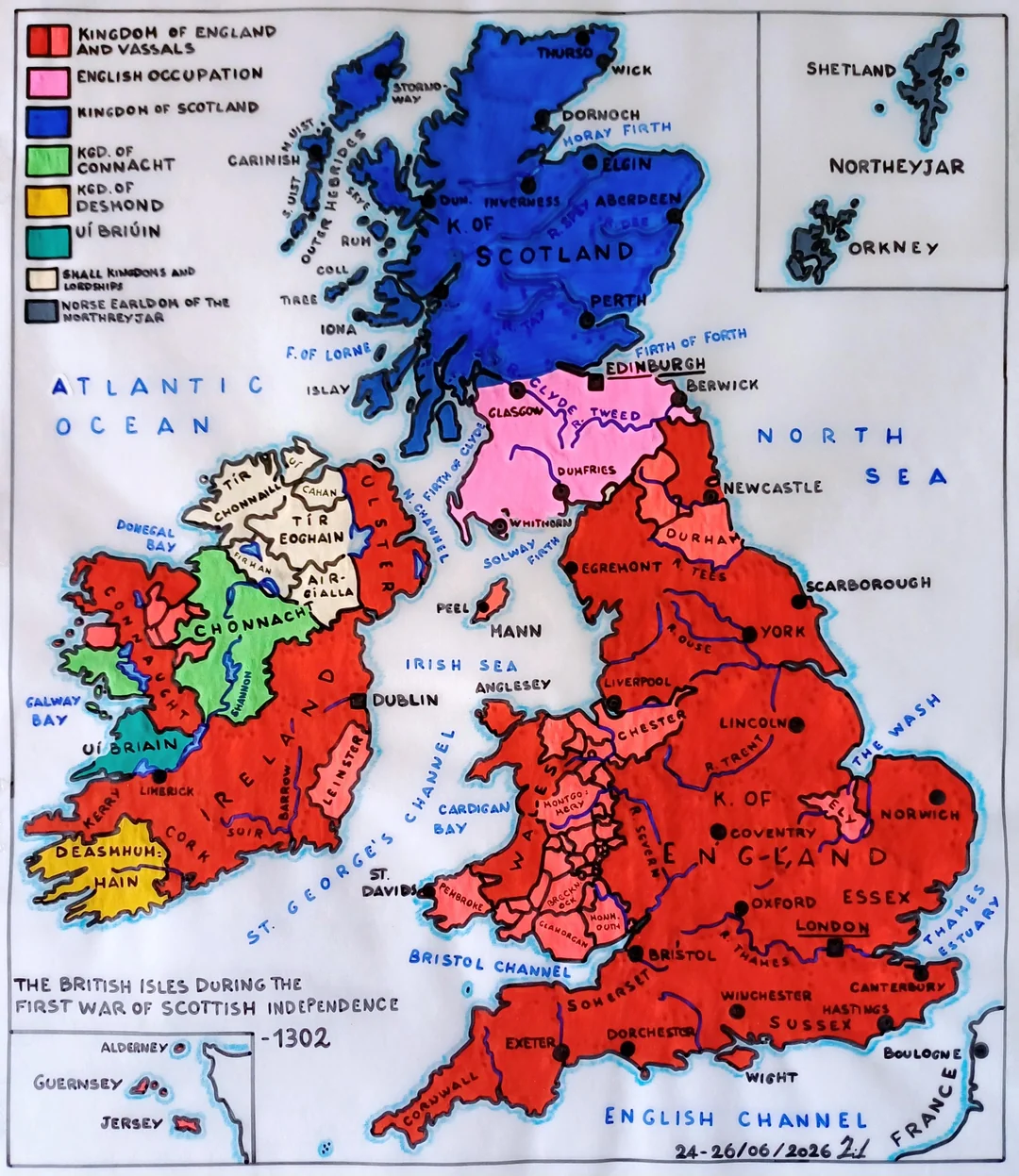
A Beautiful Hand-Drawn Map Of The British Isles during the First War of Scottish Independence

Map created by reddit user Fiff02

The map above shows what British Isles looked like during the First War of Scottish Independence (1296 – 1328).

According to the map author:

“The First War of Scottish Independence (1296–1328) was the conflict between Scotland and England over the independence of the Scottish kingdom.

The crisis arose after the death of King Alexander III and his heir, Margaret of Norway, who left the throne without a direct successor.

The English King Edward I intervened in the dynastic dispute, called upon to choose a ruler, and imposed his authority over Scotland by promoting the accession of John Balliol to the throne.

When Scottish nobles attempted to escape English control and allied themselves with France, Edward I invaded Scotland in 1296, deposed Balliol, and occupied the country.

During this period, important Scottish treasures were stolen, such as the crown and the famous Stone of Scone, on which Scottish monarchs were crowned. The resistance was led by William Wallace, who achieved a major victory at Stirling Bridge in 1297, but was defeated the following year at Falkirk and finally captured and executed in 1305.

The struggle continued under the leadership of Robert Bruce, crowned King of Scotland in 1306. After difficult years, Bruce managed to reconquer much of the country and in 1314 achieved a decisive victory against the English at the Battle of Bannockburn, which consolidated Scottish independence.

In the following years, Scotland strengthened its political and diplomatic position, including through the Declaration of Arbroath in 1320, which asserted the right of Scots to live in freedom.

Finally, in 1328, the Treaty of Edinburgh-Northampton officially recognized Scotland’s independence and the reign of Robert the Bruce.

The war brought fame to figures such as William Wallace and Robert the Bruce, who became symbols of resistance and Scottish national identity.”

You can view close-ups of the maps here.

Filed Under: United Kingdom

Click To Get My 10 Best Brilliant Maps For Free:


Other Popular Maps

  • Map Of Africa in 1880: 5 Years Before the Scramble

    Map Of Africa in 1880: 5 Years Before the Scramble

  • South African Republic Referendum 1960

    South African Republic Referendum 1960

  • 6 Best Game of Thrones Board Games & Expansions Reviewed & Ranked

    6 Best Game of Thrones Board Games & Expansions Reviewed & Ranked

  • The World According to Google Street View

    The World According to Google Street View

  • The Average Price of a Cup of Coffee in Every US State Map

    The Average Price of a Cup of Coffee in Every US State Map

  • 8 US States Have Laws That Prohibit Atheists From Holding Public Office

    8 US States Have Laws That Prohibit Atheists From Holding Public Office

  • Percentage of Homes With Air Conditioning Around The World

    Percentage of Homes With Air Conditioning Around The World

  • Toronto Subway vs Chengdu Metro 2010 – 2024

    Toronto Subway vs Chengdu Metro 2010 – 2024

Leave a Reply Cancel reply

Your email address will not be published. Required fields are marked *

This site uses Akismet to reduce spam. Learn how your comment data is processed.


Product Reviews · World Atlas · Settlers of Catan · Risk · Game of Thrones · Coloring Books
Globes · Monopoly · Star Wars · Game of Life · Pandemic · Ticket To Ride · Drinks Cabinets
US Locations · UK Locations· Fleet Management
Copyright © 2026 · Privacy Policy · Fair Use, Attribution & Copyright · Contact Us
Follow Us: Newsletter · Facebook · Youtube · Twitter · Threads · BlueSky · LinkedIn · Instagram · Pinterest · Flipboard